GIS user technology news

News, Business, AI, Technology, IOS, Android, Google, Mobile, GIS, Crypto Currency, Economics

  • Advertising & Sponsored Posts
    • Advertising & Sponsored Posts
    • Submit Press
  • PRESS
    • Submit PR
    • Top Press
    • Business
    • Software
    • Hardware
    • UAV News
    • Mobile Technology
  • FEATURES
    • Around the Web
    • Social Media Features
    • EXPERTS & Guests
    • Tips
    • Infographics
  • Blog
  • Events
  • Shop
  • Tradepubs
  • CAREERS
You are here: Home / Archives for Trimble

With New Mapping Workflow, Trimble Extends the Reach of GNSS with LTI Laser Rangefinders

December 11, 2019 By GISuser

Remote Feature Capture in Trimble TerraFlex Software Increases Productivity and Safety for GIS Mobile Workers

Filed Under: Business, Hardware Tagged With: Trimble

Trimble Expands its VRS Network Footprint with the Acquisitions of Can-Net and iBase Networks

December 5, 2019 By GISuser

Increasing Accessibility to High-Accuracy Positioning Services Across Canada and New Zealand

Filed Under: acquisitions and funding Tagged With: Trimble

Texas A&M University to Establish Trimble Technology Lab for Geosciences

November 18, 2019 By GISuser

Trimble Technology Lab Opens at Texas A&M University

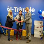
SUNNYVALE, Calif. and COLLEGE STATION, Tex., Nov. 14, 2019—Texas A&M University has received a gift from Trimble (NASDAQ: TRMB) to establish a state-of-the-art Trimble Technology Lab in the College of Geosciences. The Lab will provide an integrated field and classroom experience that will empower geospatial education at the University.

Filed Under: Business, EDU Tagged With: Education, Trimble

Trimble Clarity Now Offered as Web Application for Point Clouds and 3D Models

November 7, 2019 By GISuser

Trimble Clarity Now Offered as Web Application for Point Clouds and 3D Models

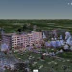
Easy Sharing Makes 3D Invaluable for Everyone

Filed Under: LiDAR, Software Tagged With: lidar, Trimble

Trimble to Acquire Cityworks to Expand Its Digital Asset and Infrastructure Management Solutions

October 4, 2019 By GISuser

Trimble Launches VRS Now Service in New Mexico

SUNNYVALE, Calif., Oct. 3, 2019—Trimble (NASDAQ: TRMB) announced today it has signed a definitive agreement to acquire privately-held Azteca Systems LLC (dba “Cityworks”), a leading provider of enterprise asset management (EAM) software for utilities and local government. Cityworks’ solutions address the global challenges associated with maintaining and replacing aging utility, transportation, and public assets and […]

Filed Under: acquisitions and funding, Business, Top Press Tagged With: Trimble

Trimble Pivot Platform and Alloy GNSS Reference Receiver Now Support BeiDou Generation III Signals

September 17, 2019 By GISuser

Trimble Leverages Evolving GNSS Constellation Technology to Deliver High-Quality Real-Time Positioning Data

Filed Under: Hardware Tagged With: Trimble

Trimble Blends Performance and Simplicity with New X7 3D Laser Scanning System

September 16, 2019 By GISuser

Trimble Blends Performance and Simplicity with New X7 3D Laser Scanning System

Innovative High-Speed 3D Laser Scanning System Simplifies Use, Increases Efficiency and Provides Confidence in the Field to Capture Digital Data

Filed Under: Business, GPS, Hardware, Top Text Lead Story Tagged With: GNSS, Trimble

Trimble Announces New Offline Data Transfer, Post-Processing Workflow for Trimble TerraFlex Software

September 6, 2019 By GISuser

Trimble Announces New Offline Data Transfer, Post-Processing Workflow for Trimble TerraFlex Software

SUNNYVALE, Calif., Sept. 4, 2019—Trimble (NASDAQ: TRMB) announced today its Trimble® TerraFlex™ field software now supports the transfer of data between the field and office without the use of Trimble cloud services.

Filed Under: Software, Top Text Lead Story Tagged With: Trimble

Trimble Introduces New Compact-Sized Tablet for Geospatial Field Applications

August 13, 2019 By GISuser

Trimble T7 Tablet Offers Rugged Flexibility and Mobility in the Field

Filed Under: GPS, Hardware, Top Press Tagged With: rugged, tablet, Trimble

GeoTech Webinar Tip: What’s New in eCognition 9.5

July 27, 2019 By GISuser

ecognition

Version 9.5 is a major release and continues to leverage the latest feature extraction technology to solve challenging problems faster and more accurately for remote sensing specialists, Geographic Information System (GIS) experts, cartographers, photogrammetry and other geospatial professionals.

Filed Under: Featured Webinar, Webinars Tagged With: ecognition, imaging, Trimble

« Previous Page
Next Page »

Recent Industry News

The Future of Competitive Gaming: Why DMA Technology is the Ultimate Performance Edge

June 24, 2026 By GISuser

Milwaukee M18FHZ-0 Hackzall Reciprocating Saw – For hardcore cutting in a compact size

June 19, 2026 By GISuser

How Enterprises Are Using AI to Automate 80% of Customer Interactions With Voice Agents

June 16, 2026 By GISuser

Why On Cloud Shoes Are Worth the Price in Mexico

June 16, 2026 By GISuser

Hot News

State of Data Science Report – AI and Open Source at Work

HERE and AWS Collaborate on New HERE AI Mapping Solutions

Virtual Surveyor Adds Productivity Tools to Mid-Level Smart Drone Surveying Software Plan

Categories

Copyright gletham Communications 2015 - 2026

Go to mobile version