
Latest Release Adds Identify Tool Enhancements to Quickly Find GeoPackage Features with the Click of a Button and ArcGIS 10.6.1 Compatibility
TerraGo Selected for Smart 50 Award
TerraGo Streetlights application chosen for industry award at smart city event and will be showcased in “Building Smarter Cities” webinar
TerraGo Launches New GXP InForm Application for BAE Systems’ GXP Xplorer
GXP InForm™, an add-on module for GXP Xplorer®, helps better connect command units and fielded operators with actionable imagery, location-based reporting and cloud-based collaboration.
TerraGo® Adds Topcon® GNSS Receiver Integration to Mobile Data Collection Platforms
With TerraGo Magic, partners and customers can build custom mobile apps integrated with Sokkia high-accuracy receivers that deliver RTK cm-level performance to smartphones and tablets.
TerraGo and Laser Technology Partner to Integrate Industry-Leading Rangefinders with Advanced Field Data Collection Apps
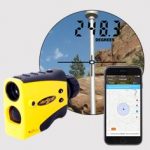
TerraGo Magic, the industry’s first zero-code platform for building custom apps, now includes support for TruPulse® laser rangefinders to improve accuracy, efficiency and safety of field data collection work in numerous industries including energy, utilities, transportation, environmental, engineering and more
TerraGo Adds New Advanced Features to Magic Apps
TerraGo Magic now offers new features including laser range finder integration, navigation, guidance and proximity alerts that can be instantly added to any customer app and are also immediately available with TerraGo Edge on iOS and Android
Structural Integrity Chooses TerraGo Magic to Build Customized Field Data Collection App
Using the TerraGo Magic zero-code platform-as-a-service, Structural Integrity is building a cloud-enabled mobile inspection app integrated with Trimble® high-accuracy GNSS receivers
Seiler Instrument Chooses TerraGo Magic to Build its Mobile GNSS App Platform
Seiler to offer mobile data collection app and cloud-enabled platform built entirely using TerraGo Magic, the industry’s only zero-code platform-as-a-service
TerraGo Partners with Duncan-Parnell for Mobile Data Collection
Duncan-Parnell to provide TerraGo mobile geospatial and field surveying solutions to its customers across eight states and the District of Colombia.
TerraGo Partners with CompassTools to Deliver Advanced GIS & GPS Data Collection Solutions
CompassTools to help customers deploy custom TerraGo mobile data collection solutions with integrated support for industry-leading hardware and software platforms, including Trimble® and Esri®