Supergeo Technologies, the global leading GIS software and solution provider, announced that Institute of Geosciences and Earth Resources, National Research Council of Italy (CNR) utilizes SuperSurv and SuperGIS Desktop to collect and process various GIS data to examine the changes and status of the Earth system.
SuperGIS 3D Earth Server Updates with Stronger Functionality
Supergeo Technologies, the global leading GIS software and solution provider, releases the latest SuperGIS 3D Earth Server 3.2 with diverse enhancements and structure modifications to elevate user experience of 3D GIS data viewing.
Supergeo Extends Free SuperGIS Desktop License Policy for Students
Supergeo Technologies, the leading GIS software provider, announced the extended policy of free SuperGIS Desktop 3.2 license for students. The universities, colleges and high schools that purchase SuperGIS Desktop Lab Kit may apply for free licenses for their students to run SuperGIS Desktop 3.2 on personal computers.
SuperGIS-Powered TGOS Online Map Won Asia Geospatial Excellence Award
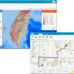
Supergeo Technologies, the global leading GIS software and solution provider, announces that SuperGIS-powered Taiwan Geospatial One Stop, aka TGOS Cloud Services, is honorably selected as Asia Geospatial Excellence Award by Asia Geospatial Forum 2014.
SuperGIS is Selected for Public Infrastructure in Nepal
Supergeo Technologies, the global leading GIS software and solution provider, announces that Rajdevi Engineering Consultant utilizes SuperGIS Desktop, SuperGIS Spatial Analyst and SuperGIS 3D Analyst in several governmental public infrastructure projects in Nepal.
SuperGIS Supports Orienteering Club Charity Map Projects
Supergeo Supergeo Technologies, the global leading GIS software and solution provider, announces that Star Vision Ltd., Supergeo Certified Reseller in Hong Kong, Macau and Guangdong, utilizes SuperGIS in a charity map project for Hong Kong Orienteering Club (HKOC).
SuperGIS Mobile Tour 3.0.1 (Android Version) Released Globally
SuperGeo Technologies, the leading global provider of complete GIS software and solutions, today announced that the latest SuperGIS Mobile Tour 3.0.1 for Android platform is now officially released worldwide.