GIS user technology news

News, Business, AI, Technology, IOS, Android, Google, Mobile, GIS, Crypto Currency, Economics

  • Advertising & Sponsored Posts
    • Advertising & Sponsored Posts
    • Submit Press
  • PRESS
    • Submit PR
    • Top Press
    • Business
    • Software
    • Hardware
    • UAV News
    • Mobile Technology
  • FEATURES
    • Around the Web
    • Social Media Features
    • EXPERTS & Guests
    • Tips
    • Infographics
  • Blog
  • Events
  • Shop
  • Tradepubs
  • CAREERS
You are here: Home / * PRESS / Software / SuperGIS 3D Earth Server Updates with Stronger Functionality

SuperGIS 3D Earth Server Updates with Stronger Functionality

December 31, 2014 By GISuser

Supergeo Technologies, the global leading GIS software and solution provider, releases the latest SuperGIS 3D Earth Server 3.2 with diverse enhancements and structure modifications to elevate user experience of 3D GIS data viewing.

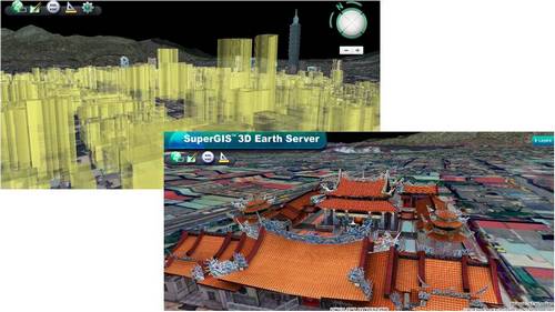
SuperGIS 3D Earth Server 3.2 is the enterprise GIS sever that allows organizations to display and share huge geospatial data in 3D view, a breakthrough technology in traditional GIS systems. By exploring the data in the virtual globe, it is much easier to see the spatial relationships among different features, to assist efficient decision making with a comprehensive perspective.

SuperGIS 3D Erath 3.2 plug-in and its stand-alone application support an additional graphic engine, DirectX, as an alternative to OpenGL, and users can choose either one to achieve best performance.

In addition, new web plug-in APIs and JavaScript APIs are provided for developers to customize the websites per their demand more easily. The stability of SuperGIS 3D Earth Server has also been improved with better quality for enterprise GIS services.

Demo sites for global users are now launched to view the capability of SuperGIS 3D Earth Server.

Explore SuperGIS 3D Earth Server (Web plug-in needed)
http://3d.supergeo.com.tw:81/world/page.htm

Free trial of SuperGIS 3D Earth Server and web plug-in
http://www.supergeotek.com/download_6_server.aspx

Filed Under: Software Tagged With: 3D, Earth Server, SuperGIS

Editor’s Picks

OpenAerialMap – The open collection of aerial imagery

Google Announces that Google Earth Pro is now free

Social Guide – The Definitive Starting Point for Mastering your Twitter Analytics

US Army Corps of Engineers Selects SimActive for Drones

See More Editor's Picks...

Recent Industry News

The Future of Competitive Gaming: Why DMA Technology is the Ultimate Performance Edge

June 24, 2026 By GISuser

Milwaukee M18FHZ-0 Hackzall Reciprocating Saw – For hardcore cutting in a compact size

June 19, 2026 By GISuser

How Enterprises Are Using AI to Automate 80% of Customer Interactions With Voice Agents

June 16, 2026 By GISuser

Why On Cloud Shoes Are Worth the Price in Mexico

June 16, 2026 By GISuser

Hot News

State of Data Science Report – AI and Open Source at Work

HERE and AWS Collaborate on New HERE AI Mapping Solutions

Virtual Surveyor Adds Productivity Tools to Mid-Level Smart Drone Surveying Software Plan

Categories

Copyright gletham Communications 2015 - 2026

Go to mobile version