GIS user technology news

News, Business, AI, Technology, IOS, Android, Google, Mobile, GIS, Crypto Currency, Economics

  • Advertising & Sponsored Posts
    • Advertising & Sponsored Posts
    • Submit Press
  • PRESS
    • Submit PR
    • Top Press
    • Business
    • Software
    • Hardware
    • UAV News
    • Mobile Technology
  • FEATURES
    • Around the Web
    • Social Media Features
    • EXPERTS & Guests
    • Tips
    • Infographics
  • Blog
  • Events
  • Shop
  • Tradepubs
  • CAREERS
You are here: Home / Archives for 3D

Hexagon Unveils M.App X 2020 for Enhanced Imagery Intelligence

January 27, 2020 By GISuser

Hexagon Unveils M.App X 2020 for Enhanced Imagery Intelligence

Latest release delivers 3D display modes and accelerated visualization and analysis

Filed Under: Software, Top Text Lead Story Tagged With: 3D, Hexagon

Concept3D’s New 3D Panorama Feature Simplifies Space Planning

October 15, 2019 By GISuser

Concept3D’s New 3D Panorama Feature Simplifies Space Planning

System Saves Time and Money by Presenting Multiple, 3D-Rendered Layout Options for Any Space

Filed Under: Software, Top Press Tagged With: 3D, Panorama

Orbit GT launches 3D Mapping Cloud v19.10

October 11, 2019 By GISuser

Portion of the Rotterdam 3D Model © Kavel 10, The Netherlands

Lokeren, Belgium, October 10th, 2019 Orbit GT announces the launch of version 19.10 of 3D Mapping Cloud.

Filed Under: Software, Top Press Tagged With: 3D, Orbit GT

Concept3D Announces Boca Center as Latest Retail Location to Launch its Immersive Map Platform

July 23, 2019 By GISuser

Concept3D Announces Boca Center as Latest Retail Location to Launch its Immersive Map Platform

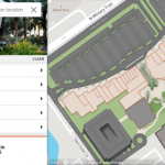
New Interactive Map Highlights Potential of Concept3D Platform to Showcase Retail, Malls, Restaurants and Hotels

Filed Under: Business, Web Services Tagged With: 3D, retail

Webinar / Video – The Modern Drone Mapping Project – Choosing the Right Approach

July 18, 2019 By GISuser

Didn’t catch the live webinar streamed from the ESRIUC? No problem, enjoy this video archive – The Modern Drone Mapping Project – Choosing the Right Approach, presented by Woolpert as part of the LiDAR Magazine webinar series.

Filed Under: Hot Webinars, LiDAR, Top Text Lead Story, UAV/UAS, VIDEOS, Webinars Tagged With: 3D, lidar, UAV, Video, Webinar, Woolpert

SOLV3D Announces New Product Branding and the Addition of a Widget for Esri ArcGIS Enterprise

July 18, 2019 By GISuser

CALGARY, AB – July 17, 2019 – SOLV3D, a leading provider of 3D processing, geospatial data visualization and collaboration tools is excited to announce a new look and feel for their corporate branding and fresh new product names.

Filed Under: Software Tagged With: 3D, arcgis enterprise, solve3d

Former NGA Director Robert Cardillo Joins Cesium’s Advisory Board

July 17, 2019 By GISuser

PHILADELPHIA, July 16, 2019  — Cesium is thrilled to announce that Robert Cardillo, the former Director of the National Geospatial-Intelligence Agency (NGA), has joined the company’s advisory board. 

Filed Under: Business, People, Hires, Career Tips Tagged With: 3D, cesium, Imagery

Nearmap unveils game-changing streaming 3-D online and previews AI technology at Navig8

June 8, 2019 By GISuser

nearmap

South Jordan, Utah, June 6, 2019 — Aerial imagery business, Nearmap, today launched its new 3-D product in a move that will revolutionize the way industries such as urban planning, architecture, construction, government and councils view and shape cities across Australia and the U.S. The company is also previewing its groundbreaking AI technology at its customer event, […]

Filed Under: Business, Earth Imaging - Remote Sensing, Top Text Lead Story Tagged With: 3D, Imagery

Solv3D Releases New Features and Pricing Model

May 28, 2019 By GISuser

CALGARY – April 24, 2019  – Solv3D, a leading provider of 3D processing, geospatial data visualization and collaboration tools announced that a number of new features have recently been released within SiteVisit360™ and 3DPointLogic™ along with a newly developed pricing model for the latter. 

Filed Under: Earth Imaging - Remote Sensing, Software Tagged With: 3D

Bluesky and Skyline Create Dynamic 3D City Models

May 18, 2019 By GISuser

Bluesky and Skyline Create Dynamic 3D City Models

Ashby-De-La-Zouch, UK – May 13, 2019 – Aerial mapping company Bluesky is working with SkylineGlobe UK on a project to provide high accuracy, photorealistic 3D City Models that will be available as off the shelf datasets and via an internet streaming service.The new, dynamic 3D models will provide a visualisation and analytical platform for smart city […]

Filed Under: Business, Earth Imaging - Remote Sensing Tagged With: 3D

« Previous Page
Next Page »

Recent Industry News

The Drift Between Early Notes and Final Case Files in Abuse-Related Legal Support

April 29, 2026 By GISuser

Aerial Surveys Int’l and Global Marketing Insights to Present GEOINT 2026 Workshop on Multi-Domain Geospatial Fusion for Automated Infrastructure Monitoring

April 24, 2026 By GISuser

Why Timing Matters More Than You Think With Spray Seal (And Why People Often Get It Slightly Wrong)

April 22, 2026 By GISuser

The Quiet Planning Stage Most People Don’t See When Building a Pool in Brisbane

April 22, 2026 By GISuser

Hot News

State of Data Science Report – AI and Open Source at Work

HERE and AWS Collaborate on New HERE AI Mapping Solutions

Virtual Surveyor Adds Productivity Tools to Mid-Level Smart Drone Surveying Software Plan

Categories

Copyright gletham Communications 2015 - 2026

Go to mobile version