GIS user technology news

News, Business, AI, Technology, IOS, Android, Google, Mobile, GIS, Crypto Currency, Economics

  • Advertising & Sponsored Posts
    • Advertising & Sponsored Posts
    • Submit Press
  • PRESS
    • Submit PR
    • Top Press
    • Business
    • Software
    • Hardware
    • UAV News
    • Mobile Technology
  • FEATURES
    • Around the Web
    • Social Media Features
    • EXPERTS & Guests
    • Tips
    • Infographics
  • Blog
  • Events
  • Shop
  • Tradepubs
  • CAREERS
You are here: Home / * PRESS / Earth Imaging - Remote Sensing / Maxar Shares Satellite Imagery of California Wildfires

Maxar Shares Satellite Imagery of California Wildfires

October 25, 2019 By GISuser

An update via Mxar: Maxar’s WorldView-3 satellite collected a set of new images yesterday, October 24th of the Kincade wildfire near Sonoma, California.

The images include both our natural color images as well as our commercially unique shortwave infrared (SWIR) imagery. SWIR imagery is particularly helpful in monitoring wildfires as it enables us to penetrate most of the smoke and easily detect both the active fire lines as well as identify the burned vegetation. With SWIR imagery, healthy (not burned) vegetation appears in shades of blue, while burned areas appear orange/rust color. The active fire areas glow red/orange.
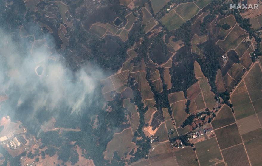
sonoma vineyards_kincade fire_natural color satellite image_24october2019_wv3

sonoma vineyards_kincade fire_natural color satellite image_24october2019_wv3

geyserville california and fire_24october2019_swir satellite image

geyserville california and fire_24october2019_swir satellite image

overview of western edge of kincade fire_sonoma_swir satellite image_24oct2019

overview of western edge of kincade fire_sonoma_swir satellite image_24oct2019

kincade fire_sonoma california_shortwave infrared image_24oct2019_wv3

kincade fire_sonoma california_shortwave infrared image_24oct2019_wv3

photo credit “Satellite image ©2019 Maxar Technologies

Filed Under: Earth Imaging - Remote Sensing, Top Press Tagged With: California, Imagery, maxar, wildfire

Editor’s Picks

LizardTech White Paper Reveals 12 Hidden Gems in GeoExpress Software

Blue Marble Announces Advanced LiDAR Option for the Global Mapper SDK

Microsoft unveils the future of Windows

DigitalGlobe Satellite Captures Dramatic Images of Alberta, Canada Oil Sands wildfire #fmmfire

See More Editor's Picks...

Recent Industry News

Why Bathroom Renovation Services Often Change More Than Just the Bathroom

May 20, 2026 By GISuser

The Drift Between Early Notes and Final Case Files in Abuse-Related Legal Support

April 29, 2026 By GISuser

Aerial Surveys Int’l and Global Marketing Insights to Present GEOINT 2026 Workshop on Multi-Domain Geospatial Fusion for Automated Infrastructure Monitoring

April 24, 2026 By GISuser

Why Timing Matters More Than You Think With Spray Seal (And Why People Often Get It Slightly Wrong)

April 22, 2026 By GISuser

Hot News

State of Data Science Report – AI and Open Source at Work

HERE and AWS Collaborate on New HERE AI Mapping Solutions

Virtual Surveyor Adds Productivity Tools to Mid-Level Smart Drone Surveying Software Plan

Categories

Copyright gletham Communications 2015 - 2026

Go to mobile version