By searching public posts, the National Geospatial-Intelligence Agency fulfills its duty to provide decision-makers with past, present and future insights into locations during a global emergency. The NGA isn’t the only agency augmenting their data analysis efforts, analysis and mapping with the inclusion of public social media feeds. There are many ways that real-time public data via the crowd, secured from social media, can augment data analysis, mapping and decision making.
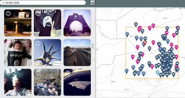 Public Social Media feeds mapped in Syria (Image Credit: DefenseOne)
The following are just a few of the uses for the inclusion of public social data:
Social search supporting TSA activities
Transportation Security Administration moved Kelly Hoggan, chief of U.S. airport security, to another position after outraged flyers posted numerous pictures and videos on social media outlets in recent days showing security lines snaking through airport terminals at a snail’s pace. The analysis of tweets and Instagram posts from frustrated travelers resulted in immediate action to resolve the problem. See More
Weather Forecasting
The USGS employs the use of Twitter to create a Twitter feed and map provide real-time water, weather and flood forecasting for Texas. The Twitter feeds and Texas Water Dashboard can do more than assist residents during flooding. Understanding weather and streamflow can help determine the best places to go boating, fishing or hiking. See More
Medical / Health Tracking
Health professionals have turned to social media to view patterns , hotspots and trends in occurrence of the flu. The flutracker uses big data from the Twitter pipe to see where the flu has been and predict where it is going next – see more Info
Social Media for Fed Background Checks
Federal agencies and background checks – On May 13, 2016, the Office of the Director of National Intelligence (“ODNI”)announced a new policy under which federal agencies may consider publicly available social media information in connection with an application for a security clearance. See more
Track Wildfires Across the Western US with Interactive Esri Maps
View continuously updated information about wildfires and their perimeters from the USGS and other agencies. You can also see live weather warnings and wind information from NOAA, as well as live weather radar from AccuWeather. Get a local perspective on events by turning on geotagged social media from Twitter, YouTube, and Flickr on the Layers tab. See More
Employee Search and Recruiters
Head hunters, recruiters and employers using social media search to seek information about current employees and potential condidates. Reputation search and management via social media has become a widely used tool by HR. See More
Business use
Social media mapping is just a part of an overall social media strategy. Businesses are constantly using social media to improve, including using it to watch competitors, interact with their current customers and reach new markets. See More
Law Enforcement
A 2013 social media survey from the International Association of Chiefs of Police found that 96 percent of police departments use social media in some capacity, more than 80 percent say it has helped them solve crimes, and 73 percent of agencies said it helped improve police-community relationships in their jurisdiction. See More
Military Movements
Satellite images, digital detective work and social media provide strongest evidence yet of Russian crossborder shelling, according to investigation via the Guardian. Recall also, last year when the government used Echosec social search service to identify key areas in the Syria conflict. See More
Conflict and Social Unrest
Back in 2011 Esri was serving a Libya Unrest map application that disseminates information being sent via Twitter, YouTube, and Flickr. The social media layers allow for custom keyword searches. Streetmap, OpenStreetMap, satellite imagery, and topographic maps are part of the map overlay. The public Ushadihi layer shows mapped reports. Additional map layers added as data becomes available. See More
The future of social media in data analysis and big data analytics was discussed in the recently published 2016 State of the Geoint Report. From the report… “As youth who have never experienced a day without Twitter, Instagram, Snapchat, or Pinterest—who conduct “research” by opening Wikipedia and linking to source documentation and monitor their every activity with Fitbit and Apple Watch—enter the GEOINT workspace, they are radically underwhelmed by available tools, techniques, and processes. For example, newsworthy events are often posted, discussed, and dissected on Twitter before they are even detected in more traditional ways. Thus far, attempts to duplicate open capabilities inside the secure world suffer from the economies of scale the open cloud provides. To fully enable our workforce, true access to all information portals will need to be embraced. If this occurs, then the analyst of 2025 would experience a very different spectrum of activities for information gathering and synthesis.” Source: State of the Geoint report 2016 http://usgif.org/education/StateofGEOINT
How is your organization using social media in your workflows? Share your thoughts with @gletham on Twitter
Suggested Resources:
- TrendHunter – Social Media Mapping
- SnapTrends
- Echosec Location-based search
- Geofeedia
- Esri Story Maps
- Tableau