GIS user technology news

News, Business, AI, Technology, IOS, Android, Google, Mobile, GIS, Crypto Currency, Economics

  • Advertising & Sponsored Posts
    • Advertising & Sponsored Posts
    • Submit Press
  • PRESS
    • Submit PR
    • Top Press
    • Business
    • Software
    • Hardware
    • UAV News
    • Mobile Technology
  • FEATURES
    • Around the Web
    • Social Media Features
    • EXPERTS & Guests
    • Tips
    • Infographics
  • Blog
  • Events
  • Shop
  • Tradepubs
  • CAREERS
You are here: Home / News / Twitter, Geo Social and Social Media / Libya Unrest Map from Esri

Libya Unrest Map from Esri

March 22, 2011 By Editor

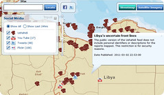
Esri is serving a Libya Unrest map application that disseminates information being sent via Twitter, YouTube, and Flickr. The social media layers allow for custom keyword searches. Streetmap, OpenStreetMap, satellite imagery, and topographic maps are part of the map overlay.

The public Ushadihi layer shows mapped reports. Additional map layers added as data becomes available. This map can be embedded in online articles – See http://www.esri.com/news/maps/libya-protest-map-2011/


Filed Under: Twitter, Geo Social and Social Media Tagged With: Geo Social and Social Media, Libya Unrest Map from Esri, News, Twitter

Editor’s Picks

Event Review, Commercial Drone Expo

DigitalGlobe Satellite Captures Dramatic Images of Alberta, Canada Oil Sands wildfire #fmmfire

Mobile Data Collection with FulcrumApp and Moving into CartoDB

Arkansas.gov Ranks Among Top 3 Government Websites

See More Editor's Picks...

About Editor

Glenn is a geographer and a GIS professional with over 20 years experience in the industry. He's the co-founder of GISuser and several other technology web publications.

Recent Industry News

Top Benefits of AI Video Surveillance for Businesses and Public Spaces

June 5, 2026 By GISuser

How to Choose the Best Office Interior Designers in Delhi for End-to-End Projects

June 3, 2026 By GISuser

Why Bathroom Renovation Services Often Change More Than Just the Bathroom

May 20, 2026 By GISuser

The Drift Between Early Notes and Final Case Files in Abuse-Related Legal Support

April 29, 2026 By GISuser

Hot News

State of Data Science Report – AI and Open Source at Work

HERE and AWS Collaborate on New HERE AI Mapping Solutions

Virtual Surveyor Adds Productivity Tools to Mid-Level Smart Drone Surveying Software Plan

Categories

Copyright gletham Communications 2015 - 2026

Go to mobile version