GIS user technology news

News, Business, AI, Technology, IOS, Android, Google, Mobile, GIS, Crypto Currency, Economics

  • Advertising & Sponsored Posts
    • Advertising & Sponsored Posts
    • Submit Press
  • PRESS
    • Submit PR
    • Top Press
    • Business
    • Software
    • Hardware
    • UAV News
    • Mobile Technology
  • FEATURES
    • Around the Web
    • Social Media Features
    • EXPERTS & Guests
    • Tips
    • Infographics
  • Around the Web
  • Events
  • Shop
  • Tradepubs
  • CAREERS
You are here: Home / * PRESS / Business / Marine Institute and TCarta Student Internship Program Makes Major Data Contribution to Seabed 2030 Project

Marine Institute and TCarta Student Internship Program Makes Major Data Contribution to Seabed 2030 Project

November 8, 2023 By GISuser

TCarta Marine, a global provider of hydrospatial products and services, has delivered three major satellite derived bathymetry (SDB) data sets to The Nippon Foundation-GEBCO Seabed 2030 project. Students in Canada participating in a 2023 summer internship program created the SDB products for the entire coastline of Madagascar, Newfoundland, and two Canadian Arctic research areas.

Marine Institute and TCarta Student Internship Program Makes Major Data Contribution to Seabed 2030 Project
The Madagascar SDB delivered to Seabed 2030, shown looking south over Nosy Hara Archipelago Marine National Park, produced from Sentinel-2 composites.

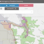
TCarta co-sponsored the first-of-its-kind SDB Internship in cooperation with Seabed 2030 and the Marine Institute (MI) of Memorial University in Newfoundland, Canada. Held at the MI Ocean Mapping facility in St. John’s, the program instructed six undergraduate and two graduate hydrography students in the use of SDB processes, satellite Earth observation platforms, advanced sensor systems, and artificial intelligence for seafloor mapping.

“As is true of most Seabed 2030 data sets, these bathymetry products will be applied in local projects as well as the global program,” said Kyle Goodrich, TCarta President. “The Canadian Arctic data, for example, will be used in fisheries research conducted by the Marine Institute.”

Goodrich will present details of the summer 2023 project at the Map the Gap Symposium being held Nov. 7-8 in Monaco.

Launched by The Nippon Foundation of Japan and the General Bathymetric Chart of the Oceans (GEBCO) program, Seabed 2030 seeks to inspire the complete mapping of the entire ocean floor by the end of the decade. A flagship program of the UN Ocean Decade, the data will be publicly available and will support coastal resilience, environmental protection, and other marine applications.

“This collaborative internship co-sponsored with our partners Memorial University and TCarta has enabled students to acquire cutting edge hydrospatial skill sets,” commented Seabed 2030 Project Director Jamie McMichael-Phillips. “The SDB data sets provided by students of the summer internship will be instrumental in supporting the global effort underway to deliver a complete map of the ocean floor by 2030.”

The student internship program is one facet of TCarta’s international capacity building initiative that seeks to instruct hydrographers worldwide in the production of SDB data for their coastlines. Training focuses on the use of TCarta’s Trident SDB Toolbox, a series of software applications running within Esri ArcGIS Pro to extract water depth measurements from remotely sensed imagery with Machine Learning and satellite LiDAR.

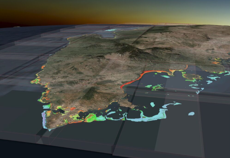
Processing government and commercial multispectral satellite imagery, the 2023 summer interns generated 10-meter resolution SDB data to depths of 25 meters along the Madagascar coast and 20 meters in Newfoundland, and seven to eight meters in the Canadian Arctic locations. NASA ICESat-2 LiDAR data was used for validation, a new technique developed by TCarta.

Coastal Madagascar was a challenge due to its geographic size and shallow water turbidity, while the murky Arctic waters were difficult due to several factors, including the scarcity of ice-free satellite images. In recent years, TCarta has significantly enhanced the utility of SDB technology in turbid, murky water conditions leveraging grants from the National Science Foundation (NSF) and National Oceanic & Atmospheric Administration (NOAA).

The two Canadian Arctic SDB data sets will also be used in Memorial University marine research activities.

“SDB is a natural fit with the in-situ soundings collected through the Qikiqtaaluk Fisheries Corporation’s Community Hydrography project and delivered through TCarta and the Marine Institute, focused on the community’s priorities and local knowledge of on-water access to their traditional hunting and fishing areas in the Qikiqtani region of Nunavut,” said Kirk Regular, Marine Geomatics Researcher at the Centre for Applied Ocean Technology at Memorial University.

Source: https://amerisurv.com/2023/11/02/marine-institute-and-tcarta-student-internship-program-makes-major-data-contribution-to-seabed-2030-project/

Filed Under: Business, Environment, Top Text Lead Story Tagged With: Marine, TCarta

Editor’s Picks

Data Tip - The US Interagency Elevation Inventory

Data Tip – The US Interagency Elevation Inventory

20th INTERGEO opens in Berlin!

Orbit GT supports LasZip for LAS 1.2 and LAS 1.4

Global Mapper 17.2 Released with New Map Book Creation Tool and Cutaway Terrain View

See More Editor's Picks...

Recent Posts

  • AC Recycling: Everything You Need to Know
  • The Rise of Talking Photo Technology: Bringing Images to Life
  • Bookkeeping in Toronto: What to Expect (and What to Avoid) When Hiring a Local Firm
  • ToMusic Review 2025: The Ultimate AI Song Maker That’s Turning Words into Emotional Hits
  • The Role of Precision Engineering in Automotive Manufacturing
  • Stopping Competitors from Misusing Trade Secrets: An Injunction Solicitor’s Role
  • How Private Investigators Detect Employee Misconduct or Policy Violations
  • Insurance Claim Denied or Underpaid in Orlando, FL? A Public Adjuster Explains Your Options
  • Why You Must Hire a Licensed Electrician in Scotts Valley, CA for Hot Tub & Pool Wiring
  • A Homeowner’s Guide to EV Charger Installation with an Electrician in Patterson, CA

Recent Features

Space Flight Laboratory (SFL) Announces Successful Launch & Deployment of HawkEye 360’s Cluster 11

FOSS4G NA 2024: The Premier Open Source Geospatial Conference Returns to St. Louis, September 9-11

Photographer Touch Reveal the Top Cameras, Lenses, and Photo Editing Tools of 2022

Digitalization and Simulation at the North Pole

Natural Gas District & GIS-Centric Asset Management

More Posts from this Category

Categories

RSS Career Tips

  • Four Characteristics of the Best Virtual Employees
  • 28 Tools to Conquer the Social Media Recruiting World
  • 8 Questions Employers Should Ask About Coronavirus
  • Jobcase Launches Free Unemployment Resource Center for Workers Impacted by COVID-19
  • Must-Have Gadgets and Technology for the Remote Office Worker


featured podcast

RSS Tech pubs

  • Stay Ahead: Gain Competitive Edge with the Latest Designs and Functionality
  • Why an Accelerated PC Refresh Cycle Makes Sense Today
  • Harness the Power of AI: A Guide to Modernizing Your Workplace

RSS Computers

  • How the Cloud is Reshaping Virtual Desktops
  • Millennials as Brand Advocates - New Research Study Results
  • Vehicles Best Practices Installation Guide

RSS HR Tips

  • AWS GovCloud (US) Celebrates 10th Anniversary and a Decade of Digital Transformation in the Federal Government
  • Exploring the Impact of COVID-19 on Customer Behavior
  • The Pivot to 100% Remote Training in the Contact Center

RSS Gov Tech

  • 10 Legal Jobs You Can Get Without a Law Degree
  • J.D. Power Examines How the Inflation Reduction Act Reshapes EV Landscape
  • Making Telehealth Work for You: The Ultimate Guide

Copyright Spatial Media LLC 2003 - 2015

Go to mobile version