Hybrid Solution for On Premise and Cloud Deployment
CENTENNIAL, Colorado, 10 July 2023 – CompassCom Software has released Version 8.2 of the CompassCom GIS-centric hybrid telematics platform that can be deployed on premises or in the cloud for real-time asset tracking and comprehensive fleet management. The new version offers enhanced ease of use and more robust analytics and reporting functionality for safer, more efficient and secure fleet operations.
Developed on Esri ArcGIS technology and now supporting JavaScript 4.0, the CompassCom telematics software platform is used worldwide to track the real-time locations and status of personnel, vehicles, and other mobile assets. The platform is relied upon by critical infrastructure work forces – including public works and public safety offices – as well as departments of transportation and national government security agencies.
“Building on our 29 years as an Esri Business Partner, we have leveraged the full range of GIS capabilities in Version 8.2 to deliver superior situational awareness related to the safety of personnel and efficient operations of vehicles,” said CompassCom CEO Brant Howard. “Customized alerts and dashboards provide fleet managers with the information they need to make better decisions in real time.”
The flexible CompassCom telematics platform receives location and status data from any GPS-equipped vehicle, handheld device, or high-value asset and serves that information in real-time to a GIS map display or an interactive dashboard. Live alerts give managers instant insight into fleet activities for better decision making, while real-time vehicle performance analytics and reporting enable fine tuning of operational efficiencies.
CompassCom developed the telematics solution to utilize Esri JavaScript API and Esri data formats, The platform also offers data portability to CAD systems, asset management, and other third-party GIS environments. When the client or agency requires hardened secure installations CompassCom offers on premises behind a firewall on the customer’s private network as an option.
“The CompassCom telematics platform is now easier to use and runs exactly the same in the cloud or on premise,” said Howard.
Key Version 8.2 enhancements include:
Geofence Alerts – Onboard sensors have long alerted fleet managers to the Speed, Ignition On/Off, Snowplow Up/Down, and Material Spreader On/Off status of individual vehicles, but alerts can now be set for Speed thresholds exceeded within specific geofences, such as parking lots or school zones.
Lost Communication – When a vehicle does not report location/status within a specified time period, an alert icon appears on the map display. The dispatcher can query the alert to see when and where the vehicle last reported along with history playback and related messages – a dramatic enhancement to personnel safety.
Advanced Material Reporting – Application of snow materials such as sand, salt, and magnesium chloride can now be consolidated into a single report for individual materials or multiple materials applied by several vehicles within a geofenced area. Managers can now know how many tons of salt were applied to streets within city limits or within a neighborhood during a snowstorm, for example.
Enhanced Onboard Diagnostics Reporting – Fleet managers can now generate reports for individual vehicles to show precisely when a Malfunction Indicator Light was activated. The report includes the precise Diagnostic Trouble Code which allows for quick and accurate assessment of needed repairs or maintenance to specific vehicles along with other engine performance KPIs.
Scheduled Reporting – The telematics platform can generate reports on any sensor outputs from vehicles (speed, mileage, material totals, etc.) and deliver them automatically to the fleet manager on a daily, weekly, monthly, or other basis.
BK Radio Compatibility – CompassCom is now the only telematics platform providing a dual interface for Motorola and BK radios. The BK brand is used extensively by federal agencies in the U.S. and internationally.
Azure AD Authentication – For customers who already use this authentication method, it is now faster and easier to log onto the CompassCom platform. This provides single sign on capabilities while adhering to customer security policies.
CompassCom personnel will be scheduling meetings to discuss Version 8.2 capabilities and other recent CompassCom solutions at the 2023 Esri User Conference in San Diego. To set up a meeting at the UC, please contact Jessica Stewart at jstewart@compasscom.com.
For more information on the CompassCom V8.2 telematics platform or to schedule an online demonstration, visit the CompassCom website at www.compasscom.com.
About CompassCom
CompassCom has been at the forefront of the Automatic Vehicle Location and the Telematics industry since 1994, providing enterprise-level fleet management solutions using the Esri ArcGIS platform. Originally designed for tracking the locations and status of vehicles, the CompassTrac® app and CompassLDE® server products are now used to monitor smartphones, private mobile radios such as Motorola and any mobile assets equipped with GPS telematics. CompassCom solutions are used across Globally by local and national governments agencies such as public safety, public works departments, DOT, Defense, and other organizations managing vehicle fleets and mobile field crews.
For more information, visit www.compasscom.com or call 1-303-680-3311.
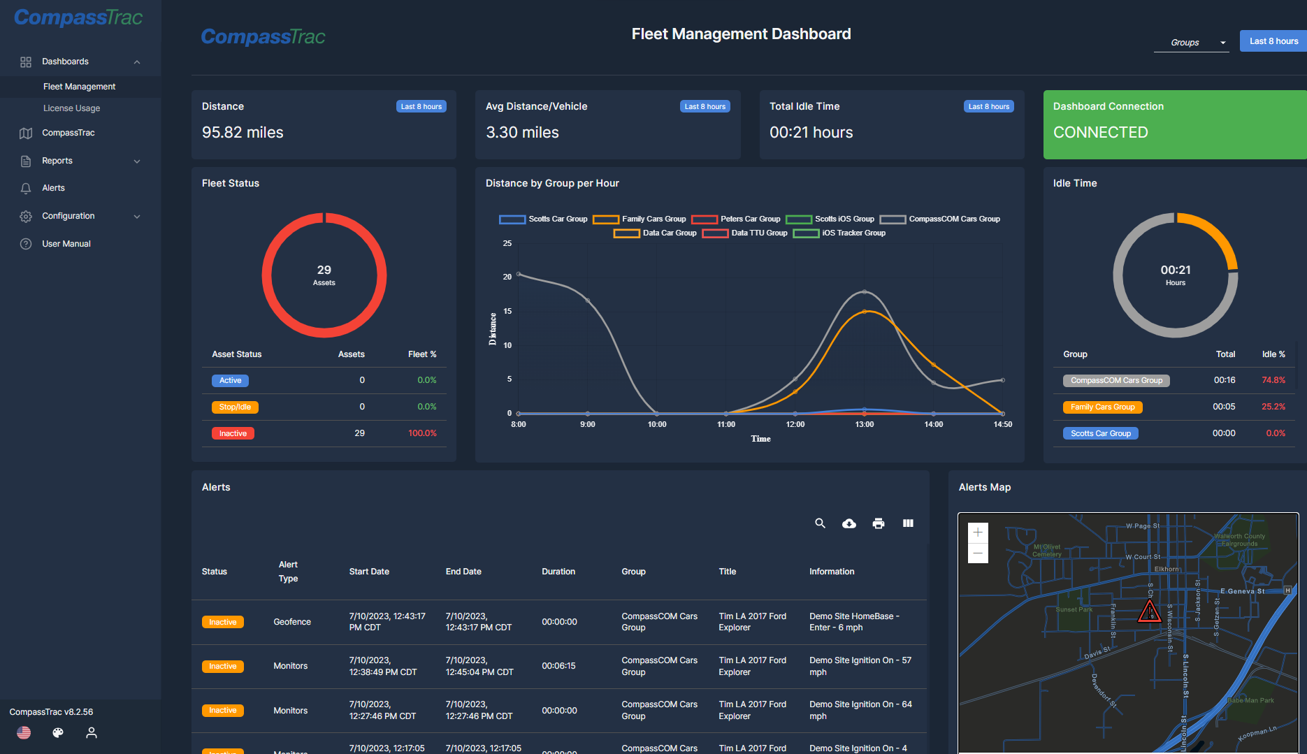
Graphic Caption: CompassCom’s telematic tracking system CompassTrac 8.2 showing real-time dashboards. KPIs are shown for fleet or radio customer giving users important real time metrics of their telematic devices.