Logan, UT – This week at the INTERGEO Conference, Juniper Systems caused a stir of excitement with the announcement of their newest rugged handheld computer—the Allegro 2™. The handheld is the latest in the company’s well-reputed Allegro product line, “with every bit of reliability,” the company says, “but now with some major advancements.”
According to Juniper Systems, the Allegro 2 was “designed for the data-intensive,” with meticulous attention paid to the engineering and design of the handheld in order to maximize efficiency and precision, both of which are critically important aspects to high-volume data collection.
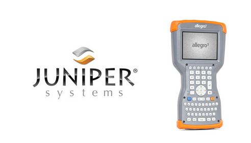
Among its list of new improvements, the Allegro 2 now features a newly designed keyboard in a QWERTY & numeric layout, with large, glove-friendly buttons for rapid—even non-visual—data entry. The new handheld features a custom Sun-to-Shade™ display—20% larger than the previous Allegro—which offers excellent visibility in any lighting conditions. The Allegro 2 is powered by a new, Overtime Technology™ battery, providing an amazing 20+ hours of runtime—extra security for long use in-between charges. And the touchscreen now utilizes capacitive technology, providing excellent durability, as well as crystal-clear imagery and greater sensitivity to touch. All of that, plus significantly enhanced GNSS performance, extended Bluetooth® range, camera & video options, and a more powerful processor make the Allegro 2 an ideal tool for high-volume data collection.
“The Allegro 2 is our next-generation product, and it includes all of the latest enhancements available in its sister product, the Archer 2™,” said John Florio, Product Manager at Juniper Systems. “The Allegro 2 was built from the ground up, based on user feedback on the jobs they have to do. Whether the customer is grading lumber in a log scaling yard, running a robotic total station, or performing a close-interval pipeline survey, the Allegro 2 is the best solution for the field today.”
The Allegro 2 is scheduled to begin shipping next month. To learn more about the Allegro 2, or to request a quote, please visit www.junipersys.com/allegro2.
About Juniper Systems:
Based out of Logan, UT, USA and Birmingham, UK Juniper Systems designs and manufactures rugged handheld computers and provides field data collection solutions for use in extreme environments. Since 1993, Juniper Systems has provided innovative mobile technology to natural resources, utilities and public services, geomatics, agriculture, industrial, and military markets. For more information on Juniper Systems products, please visit www.junipersys.com.