GIS user technology news

News, Business, AI, Technology, IOS, Android, Google, Mobile, GIS, Crypto Currency, Economics

  • Advertising & Sponsored Posts
    • Advertising & Sponsored Posts
    • Submit Press
  • PRESS
    • Submit PR
    • Top Press
    • Business
    • Software
    • Hardware
    • UAV News
    • Mobile Technology
  • FEATURES
    • Around the Web
    • Social Media Features
    • EXPERTS & Guests
    • Tips
    • Infographics
  • Blog
  • Events
  • Shop
  • Tradepubs
  • CAREERS
You are here: Home / * PRESS / Business / Satellite Imagery: Earthquake Recovery Operations in Izmir, Turkey @Maxar

Satellite Imagery: Earthquake Recovery Operations in Izmir, Turkey @Maxar

November 4, 2020 By Editor

Maxar’s WorldView-3 satellite collected new high-resolution imagery today (3 November) of Izmir, Turkey that shows rescue and recovery operations continuing in the aftermath of last Friday’s magnitude 7.0 earthquake


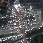
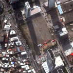
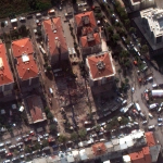
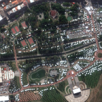
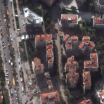
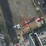
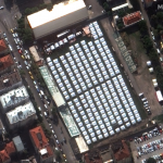
Satellite image ©2020 Maxar Technologies

Filed Under: Business, Earth Imaging - Remote Sensing Tagged With: maxar

Editor’s Picks

Botswana Geoscience Portal goes live

Event Review, Commercial Drone Expo

IN.gov Honored in 2014 Best of the Web Awards

47th Annual Magnet States Report — Where Did America Move in 2014?

See More Editor's Picks...

About Editor

Glenn is a geographer and a GIS professional with over 20 years experience in the industry. He's the co-founder of GISuser and several other technology web publications.

Recent Industry News

The Future of Competitive Gaming: Why DMA Technology is the Ultimate Performance Edge

June 24, 2026 By GISuser

Milwaukee M18FHZ-0 Hackzall Reciprocating Saw – For hardcore cutting in a compact size

June 19, 2026 By GISuser

How Enterprises Are Using AI to Automate 80% of Customer Interactions With Voice Agents

June 16, 2026 By GISuser

Why On Cloud Shoes Are Worth the Price in Mexico

June 16, 2026 By GISuser

Hot News

State of Data Science Report – AI and Open Source at Work

HERE and AWS Collaborate on New HERE AI Mapping Solutions

Virtual Surveyor Adds Productivity Tools to Mid-Level Smart Drone Surveying Software Plan

Categories

Copyright gletham Communications 2015 - 2026

Go to mobile version