GIS user technology news

News, Business, AI, Technology, IOS, Android, Google, Mobile, GIS, Crypto Currency, Economics

  • Advertising & Sponsored Posts
    • Advertising & Sponsored Posts
    • Submit Press
  • PRESS
    • Submit PR
    • Top Press
    • Business
    • Software
    • Hardware
    • UAV News
    • Mobile Technology
  • FEATURES
    • Around the Web
    • Social Media Features
    • EXPERTS & Guests
    • Tips
    • Infographics
  • Around the Web
  • Events
  • Shop
  • Tradepubs
  • CAREERS
You are here: Home / * PRESS / Business / CivilGEO Releases GeoHECRAS Version 3.0

CivilGEO Releases GeoHECRAS Version 3.0

July 7, 2020 By GISuser

Wisconsin, July 07, 2020 – CivilGEO, a leading provider of civil engineering software, has released a new version of the GeoHECRAS software. GeoHECRAS Version 3.0 utilizes an improved and easier to operate FlexNet software licensing technology from Flexera Software. This latest release provides key new features, updates, and bug fixes.

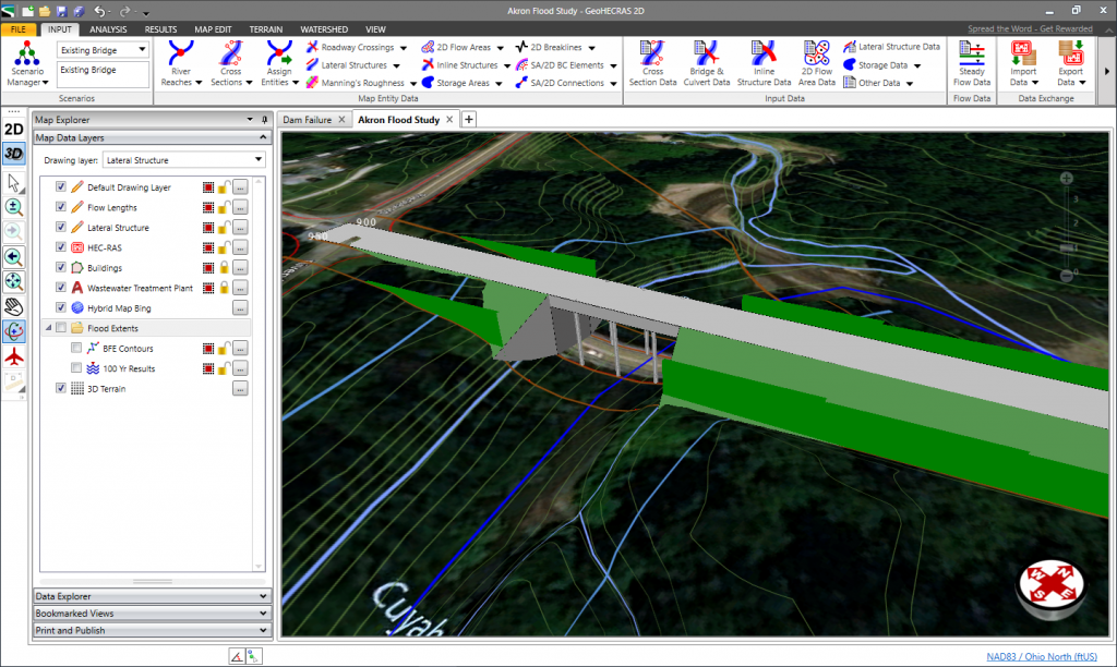
GeoHECRAS is an AutoCAD, Bentley MicroStation and ESRI ArcGIS compatible interactive 2D/3D graphical user interface data wrapper to U.S. Army Corps of Engineer’s HEC-RAS software. GeoHECRAS greatly speeds up HEC-RAS model creation and produces modeling scenarios that are more accurate and ultimately more useful to engineers.

The GeoHECRAS software rapidly constructs HEC-RAS models as it pulls data from a variety of sources. The software computes water surface profiles for steady and unsteady flow conditions, analyzes and designs bridge and culvert roadway crossings, generates floodplain and flood hazard maps, performs river and stream restorations and realignments, computes flood inundation maps for possible dam and levee failures, and much more.

Release highlights include:

  • FlexNet software licensing technology from Flexera Software
  • Draw 2D Mesh Face Command
  • Stamp Multiple Command
  • 2D Flow Training Structures
  • Elevation Profile Command
  • Google View Commands
  • Layer Properties dialog boxes – Transformation Panel
  • Multiple HEC-RAS Versions Supported
  • 2D Floodplain Encroachments Command
  • Improved Cross Section Geometry Extraction

Chris Maeder, Engineering Director at CivilGEO, said, “CivilGEO continues to develop GeoHECRAS to keep pace with the growing demands of the civil engineering community. As a company, we are responsive to our clients’ needs and very proactive in our approach to software design and implementation.”

CivilGEO develops advanced engineering and environmental modeling software for civil engineers worldwide. Consulting engineering organizations, public utilities, government agencies, and educational universities rely on CivilGEO’s software to engineer, design, and build the world’s infrastructure.

The GeoHECRAS Version 3.0 is now available for download.

 About CivilGEO, Inc.:

CivilGEO, Inc. is a privately held company headquartered in Middleton, WI, and has multiple offices in Canada, South America, Europe, Asia Pacific Region. It is a leading provider of civil engineering software designed to meet the requirements of civil engineering consulting firms and government agencies worldwide.
Filed Under: Business, Software, Top Text Lead Story

Editor’s Picks

FireWhat? Mobile GIS Lab, Emergency Incident Mapping and HP Mobile Workstations

FireWhat? Mobile GIS Lab, Emergency Incident Mapping and HP Mobile Workstations

Infographic looks at Worlds Best Selling Products: iPad, PS3 and Angry Birds

Join Esri, IBM, Amazon at the AT&T Mobile App Hackathon – Los Angeles

NOAA’s Lake Level Viewer of the Great Lakes

See More Editor's Picks...

Recent Posts

  • Everything You Need to Know About the Wavymy Hair C Part Wig
  • How Funnel Builders Simplify Online Sales for Your Businesses
  • 8 Best iPhone Data Recovery Software That Actually Work in 2025
  • The Best Features of iOS 26, iPadOS 26, and watchOS 26
  • Real-Life Scenarios Where a Type 1 Surge Protective Device Saved the Day
  • Calgary Car Detailing Costs Explained: What to Expect from Basic to Premium Packages
  • Getting Started on Poppo Live: A Real User’s Experience and Tips
  • Unlimited Virtualisation with Windows Server 2022 Datacenter Product Key
  • The Impact of Inflation on Business Finances and Growth
  • How to Landscape a Home to Sell Faster

Recent Features

Space Flight Laboratory (SFL) Announces Successful Launch & Deployment of HawkEye 360’s Cluster 11

FOSS4G NA 2024: The Premier Open Source Geospatial Conference Returns to St. Louis, September 9-11

Photographer Touch Reveal the Top Cameras, Lenses, and Photo Editing Tools of 2022

Digitalization and Simulation at the North Pole

Natural Gas District & GIS-Centric Asset Management

More Posts from this Category

Categories

RSS Career Tips

  • Four Characteristics of the Best Virtual Employees
  • 28 Tools to Conquer the Social Media Recruiting World
  • 8 Questions Employers Should Ask About Coronavirus
  • Jobcase Launches Free Unemployment Resource Center for Workers Impacted by COVID-19
  • Must-Have Gadgets and Technology for the Remote Office Worker


featured podcast

RSS Tech pubs

  • Harnessing the power of data in factory operations
  • Key strategies for smart operations transformation
  • Vodafone Business Smart Operations

RSS Computers

  • How the Cloud is Reshaping Virtual Desktops
  • Millennials as Brand Advocates - New Research Study Results
  • Vehicles Best Practices Installation Guide

RSS HR Tips

  • AWS GovCloud (US) Celebrates 10th Anniversary and a Decade of Digital Transformation in the Federal Government
  • Exploring the Impact of COVID-19 on Customer Behavior
  • The Pivot to 100% Remote Training in the Contact Center

RSS Gov Tech

  • 10 Legal Jobs You Can Get Without a Law Degree
  • J.D. Power Examines How the Inflation Reduction Act Reshapes EV Landscape
  • Making Telehealth Work for You: The Ultimate Guide

Copyright Spatial Media LLC 2003 - 2015

Go to mobile version