GISuser.com

GIS and Technology news for mapping professionals

  • PRESS
    • Submit PR
    • Top Press
    • Business
    • GIS, Geo Tech Software
    • Hardware
    • UAV News
    • Mobile Technology
    • Editor’s Top Picks
    • Get TOP Listing!
  • FEATURES
    • GeoGeeksinCars
    • 10 Question Q&A
    • FROM THE EDITOR
    • SPATIAL MEDIA AUTHORS
    • Social Media Features
    • EXPERTS & Guests
    • Listicles and Top 10 Lists
    • Infographics
    • VIDEOS
  • Events
    • Webinars
    • Submit event
    • Event Media Partner
  • CAREERS
    • Career Help Articles
    • People and Career News
    • Work from Home
    • About GeoJobs.BIZ
  • About
    • Advertise
      • Advertise wth GISuser
      • Media Kit Request Form
      • Directory
      • Submit Press
    • Contact GISuser
    • Meet the Editor
    • Social Media
      • AnyGeo Blog
      • GeoGeeks Podcast
      • Social Media Features
      • Like Us
    • SpatialMedia
      • LBSzone
      • LiDAR Magazine
      • Amerisurv
      • SymbianOne
    • RSS feed
  • Blog
  • Shop
  • Cloud Hosting
    • Amazon Cloud Hosting
    • WordPress cloud hosting
    • Dedicated servers USA
  • Tradepubs
You are here: Home / * PRESS / Environment / Schmidt Ocean Institute Maps One Million Square Kilometers of Seafloor

Schmidt Ocean Institute Maps One Million Square Kilometers of Seafloor

December 18, 2019 By GISuser

Schmidt Ocean Institute Maps One Million Square Kilometers of Seafloor and Joins Monumental Mapping Initiative

Schmidt Ocean Institute, a non-profit dedicated to advancing the world’s understanding of the ocean with cutting-edge science, reached a major milestone mapping more than one million square kilometers of ocean floor, and simultaneously made a commitment to The Nippon Foundation-GEBCO Seabed 2030 Project to help create a global map of the ocean floor.

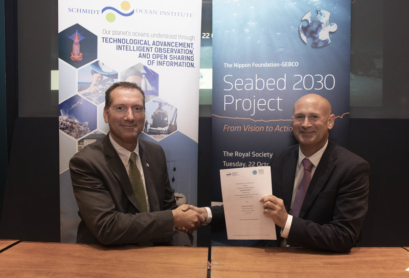
LONDON, Dec. 9, 2019 /PRNewswire/ — Schmidt Ocean Institute has come together with The Nippon Foundation-GEBCO Seabed 2030 Project for the joint signing of a Memorandum of Understanding to share all of its collected mapping data with the project. According to the Seabed 2030 Project, about 32 million square kilometers or 15% of the ocean has been mapped. The million square kilometer milestone is a big one for Schmidt Ocean, accounting for 3% of this mapping contribution and the discovery of 14 new underwater features.

R/V Falkor has hit a major milestone mapping more than a million square kilometers of ocean floor and simultaneously making a commitment to the The Nippon Foundation-GEBCO Seabed 2030 Project. Seabed 2030 is a global program aimed at creating a super-detailed map of the entire ocean floor by the year 2030. Schmidt Ocean Institute has focused its mapping on remote regions that require high-resolution seafloor imagery to contribute to expansion or additional protections.
Schmidt Ocean Institute Director of Operations Eric King and The Nippon Foundation-GEBCO Seabed 2030 former Acting Director Graham Allen sign the Seabed 2030 Memorandum of Understanding at the Royal Society in London. Image credit: John Cobb/The Nippon Foundation-GEBCO Seabed 2030 Project.

The groups met at the Royal Society, making Schmidt Ocean one of more than 100 organizations to formally support the initiative. Seabed 2030 is a global initiative aimed at creating a detailed, freely available map of the entire ocean floor by the year 2030. GEBCO (General Bathymetric Chart of the Oceans) is the only organization with a mandate to map the ocean floor.

The organizations are working together to achieve high-resolution mapping that is needed in ocean science. In fact, Seabed 2030 is working closely with the recently announced United Nations Decade of Ocean Science initiative that will begin in 2021. “While mapping the entire ocean floor by 2030 seems like a daunting task, we are making headway thanks to the commitment of commercial, scientific and private vessels, including Schmidt Ocean Institute’s R/V Falkor,” said Seabed 2030 Director Jamie McMichael-Phillips.

Schmidt Ocean Institute brings unique value due to its focus on mapping remote regions that require high-resolution seafloor imagery to contribute to expansion or additional protections. Some of its large mapping efforts have focused on the Papahanaumokuakea Marine National Monument in Hawaii, Cocos Island National Park in Costa Rica, and the Phoenix Islands Protected Area in Kiribati.

“Most people don’t think about the bottom of the ocean. When you look at a map, the ocean is portrayed as flat blue with very few features,” said Schmidt Ocean Institute co-founder Wendy Schmidt. “However, this couldn’t be further from what the ocean floor looks like. Picture huge mountains and canyons, exotic hydrothermal vent forests and unique conditions that mimic other planets. There are still so many things we do not know about the topography or the ecosystems that cover the largest part of our earth.”

Gaining visuals of the ocean floor is critical to unlocking a better understanding of the world’s oceans.  There are predicted to be millions of unknown species whose function and contribution to ocean and human health is still unknown. High resolution maps guide scientists to these unexplored areas where further study and sampling can take place. “A high-resolution map of our seafloor will be an invaluable tool in protecting our oceans,” says Schmidt.

“What is important is that these maps are open-source and available to anyone from any country,” said Schmidt Ocean Operations Director Eric King. “This effort can only be achieved through cooperation and collaboration. Everyone who travels, explores, or uses our oceans has a role to play and can benefit from this initiative.”

Schmidt Ocean Institute will provide mapping data, but has also setup dedicated mapping expeditions like “Mapping the Gaps” with its own research vessel Falkor, to help fill in the holes in previously collected mapping data. “Our organization is happy to see our data be a part of this collective initiative,” says King. “I look forward to a day when we can see an image of a fully mapped ocean.”

View a video about R/V Falkor’s mapping program & the Seabed 2030 initiative here

Related Links

http://www.schmidtocean.org

Related Articles on GISuser:

  • For You Outdoor Enthusiasts… Duraflame Campfire LogsFor You Outdoor Enthusiasts… Duraflame Campfire Logs
  • Amazing Interactive Map Reveals Earth After The Ice Melts and Sea Level RisesAmazing Interactive Map Reveals Earth After The Ice Melts and Sea Level Rises
  • White House Event Highlighting Efforts to Boost Climate Change PreparednessWhite House Event Highlighting Efforts to Boost Climate Change Preparedness
  • Real Time Social Media News Map of Colorado Flood and commentsReal Time Social Media News Map of Colorado Flood and comments
  • Colorado Wildfire information news mapColorado Wildfire information news map
  • 10th Annual International Mountain Day, December 11, 201210th Annual International Mountain Day, December 11, 2012

Filed Under: Business, Environment


Editor’s Picks

Location, Location, Location: Uses for GIS in Health Care

Location, Location, Location: Uses for GIS in Health Care

Apple Unveils All-New MacBook – The Notebook Reinvented

Where’s the Cheap Gas? The GasBuddy HeatMap Can Tell You

Esri Launches New Site to Find Open Data

See More Editor's Picks...

Connect with GISuser

  • Facebook
  • Google+
  • LinkedIn
  • RSS
  • Twitter


GIS jobs

Recent Features

Digitalization and Simulation at the North Pole

Natural Gas District & GIS-Centric Asset Management

5 Ways Technology Is Affecting The Sharing Economy

Spotlight – Township Canada: Explore Canadian Legal Land Descriptions on a Map

GeoGeeksinCars – The one in “Tippy” the right-hand drive Mitsubishi, at DevSummit

More Posts from this Category

Categories


Recent Posts

  • How to track a cell phone location online
  • How to Digitalize Every Aspect of Your Business
  • Webinar Tip – Getting Started with D3.js for Data Visualization
  • How to become a Scrum Master? Brief guide with the consistent steps
  • Locate21 approved for Austrade Business Events Grants program @locateconf

RSS Career Tips

  • Four Characteristics of the Best Virtual Employees
  • Jobcase Launches Free Unemployment Resource Center for Workers Impacted by COVID-19
  • 8 Questions Employers Should Ask About Coronavirus
  • Must-Have Gadgets and Technology for the Remote Office Worker
  • Must-Have Gadgets and Technology for the Remote Office Worker


shop for geogeek swag

RSS Tech pubs

  • Buyer's Guide to Voluntary Benefits -- A Simple Guide for HR Professionals
  • Leaning into Benefits Enrollment in the COVID Era
  • Sitecore Personalization Quick Start

RSS Computers

  • The Essentials of Information Security Kit: Includes a Free PC Security Handbook - 2nd Edition eBook
  • iPad CTO Kit - including the iPad Tips and Tricks Guide for IT Executives and Managers
  • Windows... On Speed

RSS HR Tips

  • Buyer's Guide to Voluntary Benefits -- A Simple Guide for HR Professionals
  • 2021 Regulatory & Legislative Update Handbook
  • Regulatory & Legislative Update: What Employers Need to Know in 2021

RSS Gov Tech

  • 11 Habits of Successful Law Firms - Updated for the Digital Age
  • How Legal Teams Renew Their Focus on Cost Savings
  • Whitepaper | What 300 L&D Leaders Have Learned About Building Data Fluency

RSS UAV news

  • Cobra AntiDrones is developing the concept of a interceptor drone, killer of a loitering munition and strike UAVs similar to the Turkish Bayraktar TB2
  • Webinar – Processing Large Drone Projects Webinar
  • NOAA Awards Black Swift Technologies Contract to Develop GPS-Denied Navigation

RSS Geojobs

  • An error has occurred, which probably means the feed is down. Try again later.
Copyright Spatial Media LLC 2003 - 2015