Disy, Pöyry and SoundPLAN are generating country-wide noise maps in Germany according to EU guidelines
Karlsruhe, 23.09.2016
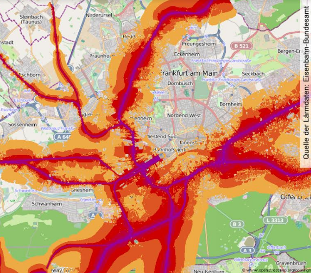
Commissioned by the German Federal Railway Authority, and under the direction of Disy Informationssysteme GmbH, the consortium of firms Disy, Pöyry and SoundPLAN are performing strategic environmental noise mapping of German rail lines up to mid-2017. By this point in time, according to EU guidelines, the third round of strategic noise mapping must be completed, not only for the main rail lines but also EU-wide for all carriageways. This major project involves not only the calculation of noise levels, but also a complex data management system to check, clean and homogenise huge quantities of data as the basis for the sound propagation calculations. The country-wide noise maps resulting from this project are the basis for noise action planning.
“It could hardly be more complicated” says Disy project leader Markus Beck of the project that he has been responsible for since November 2015. The client is the German Federal Railway Authority (FRA), which has the oversight of more than 38,000 kilometres of rail lines across the whole of Germany that transport 2 billion passengers and over 300 million tons of freight every year. The contract relates to the strategic mapping of the resulting noise. “The numbers reveal the scale of the project. And we are proud, for the third year in a row, to have won an EU-wide call in connection with the strategic noise mapping according to EU environmental noise regulations, under the jurisdiction of the FRA”.
Heterogeneous output data requires complex data management
A particular challenge relates to the almost unimaginable size and heterogeneity of the data that has to be processed. “On the one hand there is data for the railway infrastructure such as rail lines, stations, noise protection walls and German rail timetables, on the other hand, there is also data on buildings, terrain and landscape models, area usage information and data on residents from the books of various authorities such as the Federal Agency for Cartography and Geodesy, the Federal Statistics Office, the Federal Office of Civil Protection and Disaster Assistance as well as the Federal States” explains Markus Beck. This data not only comes from different sources, it comes in different formats, levels of quality and spatial layouts. These must be reconciled and verified against one another so that in the end the noise map can be calculated.
Tried-and-tested consortium in the field of environmental noise
Disy Informationssysteme GmbH has already shown in previous FRA projects that next to its technical expertise in solution concepts and data processing, it also possesses the necessary competence required to coordinate the realisation of strategic noise mapping as part of a tried-and-tested consortium with the three partners Disy, Pöyry and SoundPLAN.
The checking of input data was undertaken for the most part by the project partner Pöyry Deutschland GmbH, a consulting and engineering firm with considerable experience in the field of transport infrastructure planning that has played different roles at all levels of strategic noise mapping since 2007. Building on the evaluated timetable data and the consolidated main rail lines, Pöyry creates a 4D geometrical object that unifies all noise-relevant parameters. On the basis of this and other rail data, the digital ground model and the building and resident data, Pöyry performs the quality control for the sonic propagation calculations.
In parallel to this, Disy conceives, develops and implements the data processing, which transforms the diverse output data structures into a homogenous form that can be further processed for the strategic noise mapping. The result is the “Schalltechnische Modell” (Sonic technical model, StM), which forms the basis for the sound propagation calculations. “There are also conceptual challenges in the creation of the StM” says Markus Beck. “The goal here, for example, is to turn all rail lines, that an observer would perceive as continuous, into a single track – and this automates the calculation process. For this purpose, we have created, with Disy Spatial Workbench, a concept for database-supported geo-data processing, that is also transferable to other tasks.
The actual sound propagation calculations are carried out using the sonic technical model (StM) as the starting point. Disy provides the StM database, on the basis of which the third project partner – the software and engineering firm SoundPLAN GmbH, which specialises in noise control – performs the sound propagation calculations. SoundPLAN starts by performing a so-called “alignment correction”, in which the acoustic tracks are incorporated with the digital ground model. The noise propagation calculations then employ SoundPLAN Software, created by SoundPLAN and used all over the world, offering solutions to all aspects of noise pollution.
County-wide noise mapping for noise action planning
By mid-2017, when all the calculations are finished, the results will undergo a final processing from Disy and then be passed to the FRA in the form or noise maps, building maps and various tables. In registering these results with the Federal Environment Agency, and subsequently with the European Commission (as well as the general public in the form of a mapping service), the FRA complies with its legal obligations under EU environmental directives that member states should undertake strategic noise mapping and report the results. At the same time, the results provide the FRA with a solid basis for ongoing noise action planning.
Further information
- Environmental noise directives 2002/49/EG:
http://eur-lex.europa.eu/legal-content/DE/TXT/?uri=celex:32002L0049 - Federal Emission Protection Law (§§ 47a ff. BImSchG):
https://www.gesetze-im-internet.de/bimschg/BJNR007210974.html
- Information from the Federal Railway Authority on environmental noise directives: http://www.eba.bund.de/DE/Home/_service_nodes/laerm/laermkartierung_node.html
- Homepage Federal Rail Authority: www.eba.bund.de
- Homepage Disy Informationssysteme GmbH: www.disy.net
- Homepage Pöyry Deutschland GmbH: www.poyry.de
- Homepage SoundPLAN GmbH: www.soundplan.eu
