GISuser.com

GIS and Technology news for mapping professionals

  • PRESS
    • Submit PR
    • Top Press
    • Business
    • GIS, Geo Tech Software
    • Hardware
    • UAV News
    • Mobile Technology
    • Editor’s Top Picks
    • Get TOP Listing!
  • FEATURES
    • GeoGeeksinCars
    • 10 Question Q&A
    • FROM THE EDITOR
    • SPATIAL MEDIA AUTHORS
    • Social Media Features
    • EXPERTS & Guests
    • Listicles and Top 10 Lists
    • Infographics
    • VIDEOS
  • Events
    • Webinars
    • Submit event
    • Event Media Partner
  • CAREERS
    • Career Help Articles
    • People and Career News
    • Work from Home
    • About GeoJobs.BIZ
  • About
    • Advertise
      • Advertise wth GISuser
      • Media Kit Request Form
      • Directory
      • Submit Press
    • Contact GISuser
    • Meet the Editor
    • Social Media
      • AnyGeo Blog
      • GeoGeeks Podcast
      • Social Media Features
      • Like Us
    • SpatialMedia
      • LBSzone
      • LiDAR Magazine
      • Amerisurv
      • SymbianOne
    • RSS feed
  • Blog
  • Shop
  • Cloud Hosting
    • Amazon Cloud Hosting
    • WordPress cloud hosting
    • Dedicated servers USA
    • Linux Shared Hosting
    • Windows Shared Hosting
    • Web Development
    • SSL Certificate
  • Tradepubs
You are here: Home / * PRESS / Business / USGS Announces 3D Elevation Program (3DEP) 2016 Awards

USGS Announces 3D Elevation Program (3DEP) 2016 Awards

March 10, 2016 By Editor

The US Geological Survey National Geospatial Program is pleased to announce the first round of awards resulting from the USGS Broad Area Announcement (BAA) for the 3D Elevation Program (3DEP), initially issued on July 17, 2015. (FedBizOpps: G15PS00558 Grants.gov: G15AS00123).

Screenshot 2016-03-10 at 08.39.18

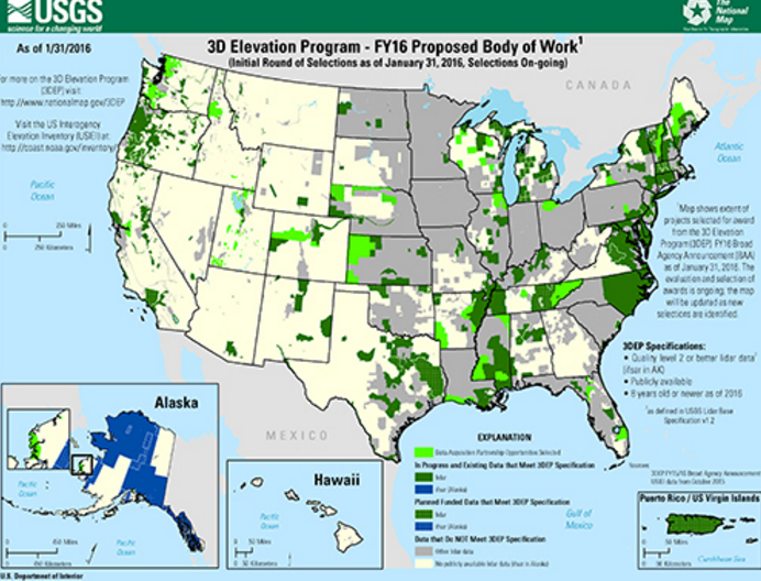
The BAA is a publicly accessible process to develop partnerships for the collection of lidar and derived elevation data for 3DEP. 3DEP presents a unique opportunity for collaboration between all levels of government, to leverage the services and expertise of private sector mapping firms that acquire the data, and to create jobs now and in the future.
The USGS, along with other federal, state, local and private agencies, is establishing the collection program to respond to the growing needs for high-quality, three-dimensional mapping data of the United States. Current and accurate 3D elevation data are essential to help communities cope with natural hazards and disasters such as floods and landslides, support infrastructure, ensure agricultural success, strengthen environmental decision-making and bolster national security. Federal funds to support this opportunity were provided by the USGS, the Federal Emergency Management Agency, and the Natural Resources Conservation Service. The USGS is acting in a management role to facilitate planning and acquisition for the broader community, through the use of government contracts and partnership agreements.

The first phase of Fiscal Year 2016 Awards has offered partnership funding to 21 proposals in 19 States and Territories.

For a larger map of BAA projects, click here

Source: USGS

Related Articles on GISuser:

  • First Round of Lidar BAA Awards ReleasedFirst Round of Lidar BAA Awards Released
  • USGS evaluates Sigma Space’s Single Photon LiDAR as a key technology for its 3D Digital Elevation ProgramUSGS evaluates Sigma Space’s Single Photon LiDAR as a key technology for its 3D Digital Elevation Program
  • Update on USGS 3D Elevation Program (3DEP) initiativeUpdate on USGS 3D Elevation Program (3DEP) initiative
  • 2015 Gannett Award Presented2015 Gannett Award Presented
  • Woolpert Selected by USGS to Evaluate New Lidar Technologies for 3DEPWoolpert Selected by USGS to Evaluate New Lidar Technologies for 3DEP
  • Category Winners Announced at the Second Annual Lidar Leader Awards CeremonyCategory Winners Announced at the Second Annual Lidar Leader Awards Ceremony

Filed Under: Business, LiDAR, Top Press Tagged With: 3dep, awards, lidar, USGS


Editor’s Picks

Using Lidar to Classify Landslides

Using Lidar to Classify Landslides

HP Inc. Wraps Up Another Power-packed NAB Show

Global Earthquake Numbers on Par for 2015

A Decade of Change in America’s Arctic: New Land Cover Data Released for Alaska

See More Editor's Picks...

About Editor

Glenn is a geographer and a GIS professional with over 20 years experience in the industry. He's the co-founder of GISuser and several other technology web publications.

Connect with GISuser

  • Facebook
  • Google+
  • LinkedIn
  • RSS
  • Twitter


GIS jobs

Recent Features

Digitalization and Simulation at the North Pole

Natural Gas District & GIS-Centric Asset Management

5 Ways Technology Is Affecting The Sharing Economy

Spotlight – Township Canada: Explore Canadian Legal Land Descriptions on a Map

GeoGeeksinCars – The one in “Tippy” the right-hand drive Mitsubishi, at DevSummit

More Posts from this Category

Categories


Recent Posts

  • National Energy System Map contract awarded to 1Spatial and Ordnance Survey by The Energy Networks Association
  • DENSO Products and Services Americas Celebrates 50 Years in America
  • USGIF Board of Directors Appoints New Chair
  • Trimble Launches Dimensions Spotlight Series for 2021
  • 5 tips for successful implementation of smartphone surveillance at work

RSS Career Tips

  • Four Characteristics of the Best Virtual Employees
  • Jobcase Launches Free Unemployment Resource Center for Workers Impacted by COVID-19
  • 8 Questions Employers Should Ask About Coronavirus
  • Must-Have Gadgets and Technology for the Remote Office Worker
  • Must-Have Gadgets and Technology for the Remote Office Worker


shop for geogeek swag

RSS Tech pubs

  • Data Driven insights for Personalized Medicine
  • The Advantages of Reshoring Your Manufacturing Operation
  • Accelerating Lung Cancer diagnosis with Artificial Intelligence

RSS Computers

  • iPad CTO Kit - including the iPad Tips and Tricks Guide for IT Executives and Managers
  • The Essentials of Information Security Kit: Includes a Free PC Security Handbook - 2nd Edition eBook
  • Windows... On Speed

RSS HR Tips

  • Fiduciary of the Future
  • The IT Training Buyer's Guide & Checklist
  • Creating A Secure Remote Work Environment eBook

RSS Gov Tech

  • Next-generation Situational Awareness - How Skydio's autonomous drone solutions protect first responders
  • AI Meets Inspection: How Autonomous Drones are Changing the Game in Enterprise
  • Cyberwarfare Requires Speed, Adaptability and Visibility to Win: Enterprises Must Close the IT Operations and Security Gap

RSS UAV news

  • Global Commercial Drone Market Expected to Exceed $8.5 Billion By 2027
  • Down to Earth – Drone Lidar Surveying Reality Series Returns
  • Florida Signs Participating Addendum with DroneUp Providing Public Sector Agencies Access to Drone Services

RSS Geojobs

  • An error has occurred, which probably means the feed is down. Try again later.
Copyright Spatial Media LLC 2003 - 2015