GIS user technology news

News, Business, AI, Technology, IOS, Android, Google, Mobile, GIS, Crypto Currency, Economics

  • Advertising & Sponsored Posts
    • Advertising & Sponsored Posts
    • Submit Press
  • PRESS
    • Submit PR
    • Top Press
    • Business
    • Software
    • Hardware
    • UAV News
    • Mobile Technology
  • FEATURES
    • Around the Web
    • Social Media Features
    • EXPERTS & Guests
    • Tips
    • Infographics
  • Blog
  • Events
  • Shop
  • Tradepubs
  • CAREERS
You are here: Home / * PRESS / Business / New: LandScan+ combines authoritative infrastructure data * with The World’s Finest Population Distribution Data

New: LandScan+ combines authoritative infrastructure data * with The World’s Finest Population Distribution Data

November 24, 2015 By GISuser

Minneapolis, Minnesota, USA – November 24, 2015 – East View introduces a new value-added geospatial solution by combining authoritative infrastructure data with the award-winning LandScanTM Global Population Database.

Developed by the Oak Ridge National Laboratory and exclusively distributed by East View, LandScan provides the most accurate and reliable ambient population data covering the globe.

LandScan+ is a new opportunity for GIS users to improve their ability to analyze and understand the impact of conditions, surroundings and events on human population dynamics.

Since 1989, East View has acquired a vast archive of global maps and geospatial datasets that can now be paired with LandScan population data.  Here are some examples:

Ukraine 1:50K topographic vector data South Africa 1:50K topographic vector data
  • Rail network
  • Road network
  • Settlements
  • Data period 2008-2011
  • Rail network
  • Road network
  • Power utilities
  • Data period 2006-2010
Vietnam 1:50K topographic vector data Myanmar 1:50K topographic vector data
  • Rail network
  • Road network
  • Power utilities
  • Hydro network
  • Cultural sites
  • Data period 2009-2010
  • Rail network
  • Road network
  • Power utilities
  • Settlements
  • Data period 2013

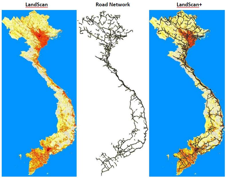
* These datasets were not used in the creation of LandScan. The images below represent the LandScan Vietnam population data and the primary road network in Vietnam that are combined to generate the LandScan+ mashup.

LandScan Road Network LandScan+

landscan

To learn more about the infinite cross-referencing opportunities, customization, sample data and pricing options with LandScan+ please contact East View at the following:

Scott Edwards
Product Manager – East View Information Services

Tel.: 952-252-1201 E-mail: scott.edwards@eastview.com

About East View

East View was founded in 1989 and is headquartered in Minneapolis, Minnesota, USA.

East View is comprised of East View Information Services (www.eastview.com), East View Geospatial (www.geospatial.com) and East View Map Link (www.maplink.com). East View maintains thousands of supplier/publisher relationships throughout the world for maps and geospatial data and Russian, Arabic and Chinese-produced social and hard science content.

East View manages a data center, library and warehouse in Minneapolis where it hosts and stores dozens of foreign language databases, hundreds of thousands of maps and atlases and millions of geospatial, Russian, Chinese and Arabic metadata records.

Filed Under: Business, DATA, Top Press Tagged With: EASTVIEW, LandScan

Editor’s Picks

Learn to Make Decisions Using Lidar Data and Geographic Information Systems

Former Governor Geringer Leads Panel Calling on Congress and Governors to Make National Spatial Data Infrastructure a High Priority

Event Review, Commercial Drone Expo

Google Announces that Google Earth Pro is now free

See More Editor's Picks...

Recent Industry News

The Future of Competitive Gaming: Why DMA Technology is the Ultimate Performance Edge

June 24, 2026 By GISuser

Milwaukee M18FHZ-0 Hackzall Reciprocating Saw – For hardcore cutting in a compact size

June 19, 2026 By GISuser

How Enterprises Are Using AI to Automate 80% of Customer Interactions With Voice Agents

June 16, 2026 By GISuser

Why On Cloud Shoes Are Worth the Price in Mexico

June 16, 2026 By GISuser

Hot News

State of Data Science Report – AI and Open Source at Work

HERE and AWS Collaborate on New HERE AI Mapping Solutions

Virtual Surveyor Adds Productivity Tools to Mid-Level Smart Drone Surveying Software Plan

Categories

Copyright gletham Communications 2015 - 2026

Go to mobile version