GISuser.com

GIS and Technology news for mapping professionals

  • PRESS
    • Submit PR
    • Top Press
    • Business
    • GIS, Geo Tech Software
    • Hardware
    • UAV News
    • Mobile Technology
    • Editor’s Top Picks
    • Get TOP Listing!
  • FEATURES
    • GeoGeeksinCars
    • 10 Question Q&A
    • FROM THE EDITOR
    • SPATIAL MEDIA AUTHORS
    • Social Media Features
    • EXPERTS & Guests
    • Listicles and Top 10 Lists
    • Infographics
    • VIDEOS
  • Events
    • Webinars
    • Submit event
    • Event Media Partner
  • CAREERS
    • Career Help Articles
    • People and Career News
    • Work from Home
    • About GeoJobs.BIZ
  • About
    • Advertise
      • Advertise wth GISuser
      • Media Kit Request Form
      • Directory
      • Submit Press
    • Contact GISuser
    • Meet the Editor
    • Social Media
      • AnyGeo Blog
      • GeoGeeks Podcast
      • Social Media Features
      • Like Us
    • SpatialMedia
      • LBSzone
      • LiDAR Magazine
      • Amerisurv
      • SymbianOne
    • RSS feed
  • Blog
  • Shop
  • Cloud Hosting
    • Amazon Cloud Hosting
    • WordPress cloud hosting
    • Dedicated servers USA
  • Tradepubs
You are here: Home / * PRESS / Business / City of Hamilton Recognized for Increasing Efficiency Using Geospatial Technology

City of Hamilton Recognized for Increasing Efficiency Using Geospatial Technology

October 14, 2015 By GISuser

Esri’s ArcGIS platform enables rapid development of apps for enhanced municipal services, data sharing & citizen engagement

City of Hamilton Recognized for Increasing Efficiency Using Geospatial Technology

TORONTO, Esri Canada User Conference – October 14, 2015 – The City of Hamilton’s corporate culture is built on courageous change, collective ownership, sensational service and empowered employees. The City fosters this culture with the help of technology. Since adopting ArcGIS, Esri’s geographic information system (GIS) platform in 2013, the City has launched several mapping apps that facilitate more efficient data and service delivery, and enhanced citizen engagement. For this outstanding work, Esri Canada today presented the City of Hamilton with an Award of Excellence in GIS.

“The City of Hamilton has achieved significant advances using ArcGIS in a relatively short time,” remarked Alex Miller, president, Esri Canada. “The apps that they’ve developed are bringing tremendous efficiencies to the City which, in turn, increase the satisfaction of their partners and citizens. Their projects effectively demonstrate how GIS supports intelligent government operations.”

Two years ago, the City’s Public Works Department evaluated ArcGIS Online to see how the cloud-based platform could be used in their operations. They attended the Esri International User Conference and were struck by the overwhelming number of apps that could be developed with the technology. Inspired by what they had seen, they worked with Esri Canada’s Professional Services team to revamp Hamilton’s online engineering records system. In 2014, the City retired its homegrown plans and records system and launched SPIDER (Spatially Indexed Engineering Records), which allows staff and partners to access more than 200,000 engineering records through an interactive Web map. SPIDER received more than 1,500 visits within its first month of release and has provided the City with an efficient data-sharing framework.

Recently, the City used ArcGIS Online to support their streetlight replacement project and meet eligibility requirements for a $3.5-million provincial grant for converting to cost-effective LED lighting. Leveraging app templates, they quickly developed a mobile app for collecting data on 10,000 municipal streetlights that need replacement. With only one full-time inspector equipped with a tablet, the City has been able to inspect all streetlights replaced by contractors, confirm that the right type of LED light was used and approve the work for payment, within five months – saving the City approximately a month of staff time.

They also created the Hamilton Streetlighting Story Map to keep stakeholders informed of the project. The map incorporates various information – such as installation timelines, types of LED lights used, approved contractors and amount of energy saved – presented in different formats into one cohesive map journal. It integrates real-time data from the City’s operational dashboard to show the number of successfully installed streetlights and includes a map with before-and-after installation photos.

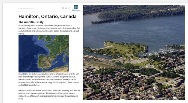
As well, the City has released Invest in Hamilton – an interactive map journal that helps attract investment. Previously, the City’s Economic Development Department used slides, videos and handouts to present their story to potential investors. Using ArcGIS Online, they have consolidated their marketing materials into an easy-to-understand story map that leverages their multimedia content.

“Our recent work with Esri Canada has empowered our employees with exceptional GIS tools for delivering greater transparency and enhanced services to citizens,” said Gord McGuire, manager, Geomatics & Corridor Management, City of Hamilton.  “ArcGIS has helped us become more agile; it has improved our capability to leverage enterprise data and quickly deploy apps to support our workflows. We’re excited about the numerous possibilities for creating apps to accelerate municipal projects across our organization.”

View a gallery of the City of Hamilton’s public works mapping apps at: hamilton.maps.arcgis.com.Learn more about the ArcGIS platform at: esri.ca/arcgis.

About the City of Hamilton

With a population of nearly 520,000, Hamilton is located at the western end of Lake Ontario in the Golden Horseshoe region. The City of Hamilton’s long-term vision is to make Hamilton the best place to raise a child, promote innovation, engage citizens and provide diverse economic opportunities. More information is available at hamilton.ca.

 About Esri Canada
Founded in 1984, Esri Canada provides enterprise geographic information system (GIS) solutions that empower businesses, governments and educational institutions to make timely, informed and mission-critical decisions by leveraging the power of geography.  The company distributes the world’s leading GIS software from Esri, Schneider Electric, Cityworks–Azteca Systems, Inc. and other technology partners.  Headquartered in Toronto, the company serves over 10,000 customers from 16 regional offices across Canada.  Esri Canada has joined the elite rank of Canada’s Best Managed companies and has been named to the Branham300.  Information about the company can be found at esri.ca. Follow Esri Canada on Twitter, Facebook, YouTube and LinkedIn.

Related Articles on GISuser:

  • Esri and ICMA Partner to Educate Smart CommunitiesEsri and ICMA Partner to Educate Smart Communities
  • Ontario Making Data Open by DefaultOntario Making Data Open by Default
  • Esri Awards GIS Users for Innovation and Global ContributionEsri Awards GIS Users for Innovation and Global Contribution
  • Federal Small Business Specialty Debuts at FedGISFederal Small Business Specialty Debuts at FedGIS
  • City of Coquitlam Recognized for GIS InnovationCity of Coquitlam Recognized for GIS Innovation
  • Esri Silver Business Partner, Bay Park DS, Awarded the Esri Release Ready Specialty DesignationEsri Silver Business Partner, Bay Park DS, Awarded the Esri Release Ready Specialty Designation

Filed Under: Business, Government & OpenGov, Top Press Tagged With: arcgis, engagement, ESRI, Hamilton, Ontario


Editor’s Picks

ArcGIS Online Updates Include Smart Mapping and More

ArcGIS Online Updates Include Smart Mapping and More

HUD and Zillow Hacking for Affordable housing

Geospago and what3words partner to provide a mobile mapping solution with 3-word addressing throughout the globe

Dev Tip- The JavaScript Anthology: 101 Essential Tips, Tricks & Hacks

See More Editor's Picks...

Connect with GISuser

  • Facebook
  • Google+
  • LinkedIn
  • RSS
  • Twitter


GIS jobs

Recent Features

Digitalization and Simulation at the North Pole

Natural Gas District & GIS-Centric Asset Management

5 Ways Technology Is Affecting The Sharing Economy

Spotlight – Township Canada: Explore Canadian Legal Land Descriptions on a Map

GeoGeeksinCars – The one in “Tippy” the right-hand drive Mitsubishi, at DevSummit

More Posts from this Category

Categories


Recent Posts

  • Address Points & Building Footprints as KML, GeoJSON, Shapefile
  • OceanWise – Delivering site surveys and installations remotely
  • OGC Members propose update to work of Features API Standards Working Group; public comment sought
  • Indian Army signs a $20 million contract with ideaForge to procure SWITCH UAV
  • OGC seeks public comment on proposal to revise Indexed 3D Scene Layers (I3S) Community Standard

RSS Career Tips

  • Four Characteristics of the Best Virtual Employees
  • Jobcase Launches Free Unemployment Resource Center for Workers Impacted by COVID-19
  • 8 Questions Employers Should Ask About Coronavirus
  • Must-Have Gadgets and Technology for the Remote Office Worker
  • Must-Have Gadgets and Technology for the Remote Office Worker


shop for geogeek swag

RSS Tech pubs

  • Planet Satellite Imagery Promotes Rapid Response to Ripple Effects of COVID-19
  • Synthetic Monitoring, Evolved
  • How to Increase Your Construction Business Revenue Through Digital Transformation

RSS Computers

  • iPad CTO Kit - including the iPad Tips and Tricks Guide for IT Executives and Managers
  • The Essentials of Information Security Kit: Includes a Free PC Security Handbook - 2nd Edition eBook
  • Windows... On Speed

RSS HR Tips

  • Considerations for Safely Returning Employees to the Workplace
  • Unlearning Your Organizational Culture: A Playbook for Leading in an Unpredictable, Virtual World
  • Outsourcing Software Development: 2021 Guide for Decision-Makers

RSS Gov Tech

  • What's New for Interactive Electronic Signing in 2021?
  • Why Smart Cities Need an Event-Driven Architecture
  • COVID-19, Remote Work and Cybersecurity Threats: 7 Pointers for In-House Counsel

RSS UAV news

  • Indian Army signs a $20 million contract with ideaForge to procure SWITCH UAV
  • senseFly launches eBee e-learning platform and operator certification program to advance drone knowledge
  • Commentary from senseFly on the the impact of the new EU drone regulation

RSS Geojobs

  • An error has occurred, which probably means the feed is down. Try again later.
Copyright Spatial Media LLC 2003 - 2015