GIS user technology news

News, Business, AI, Technology, IOS, Android, Google, Mobile, GIS, Crypto Currency, Economics

  • Advertising & Sponsored Posts
    • Advertising & Sponsored Posts
    • Submit Press
  • PRESS
    • Submit PR
    • Top Press
    • Business
    • Software
    • Hardware
    • UAV News
    • Mobile Technology
  • FEATURES
    • Around the Web
    • Social Media Features
    • EXPERTS & Guests
    • Tips
    • Infographics
  • Around the Web
  • Events
  • Shop
  • Tradepubs
  • CAREERS
You are here: Home / * PRESS / Earth Imaging - Remote Sensing / EarthDefine Maps High Resolution Tree Cover for Ohio and Pennsylvania

EarthDefine Maps High Resolution Tree Cover for Ohio and Pennsylvania

September 20, 2015 By GISuser

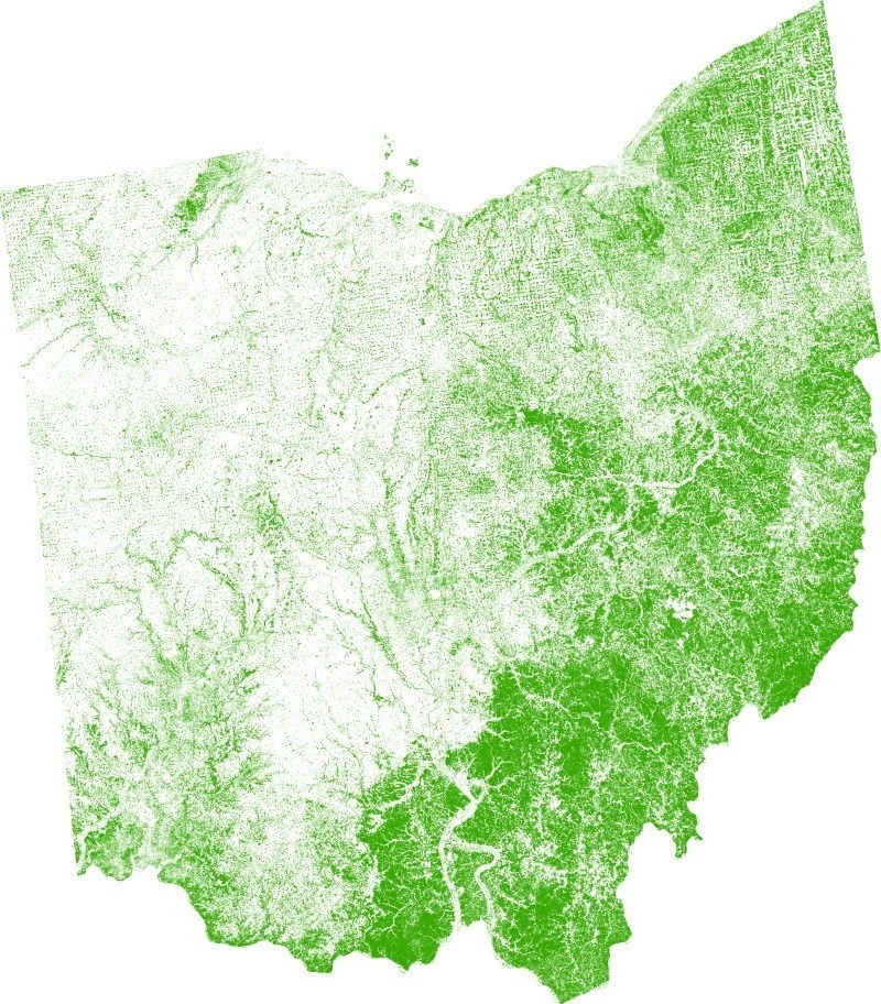
ISSAQUAH, Wash., Sept. 15, 2015 — EarthDefine, a provider of high resolution spatial data products, has created comprehensive tree datasets that seamlessly map the location of all trees and tree heights across Ohio and Pennsylvania in unprecedented detail. The new 1 meter resolution Ohio and Pennsylvania SpatialCover Tree Canopy datasets will enable multiple applications for land management and quantification of the ecosystem services provided by trees.

EarthDefine Maps High Resolution Tree Cover for Ohio and Pennsylvania

EarthDefine Maps High Resolution Tree Cover for Ohio and Pennsylvania

The Ohio and Pennsylvania datasets fill existing gaps between high resolution datasets that cover very small geographical regions and coarse-grained national tree canopy data sources like the National Land Cover Database (NLCD). Existing coarse resolution datasets underestimate trees in agricultural and urban landscapes where the tree canopy exists in small and narrow spatial configurations. EarthDefine’s tree canopy datasets map tree cover with over 95% accuracy and 30 times the resolution of existing state level datasets. These datasets provide the most accurate data source for assessing tree canopy at the regional level while also supporting detailed analysis down to the neighborhood level.

EarthDefine used multiple terabytes of color infrared imagery flown in the summer of 2010 and 2013 along with three-dimensional point cloud data from LIDAR (Light Detection and Ranging) flown between 2006 and 2014 for most of Pennsylvania and Ohio to create the statewide tree cover datasets. LIDAR is a remote sensing technology that enables accurate measurement of elevation for different ground surface types based on the light pulses reflected from the earth.  The LIDAR data was also used to create Canopy Height Models for Ohioand Pennsylvania.

EarthDefine has previously released high resolution tree canopy datasets that provide statewide coverage for Indiana, Minnesota andCalifornia. EarthDefine will continue to grow its SpatialCover Tree Canopy data product to cover more states over the next year by building on the best available orthoimagery and LIDAR data. For more information on EarthDefine products, please visitwww.earthdefine.com.

SOURCE EarthDefine

linkedin

Twitter @earthdefineLLC

Filed Under: Earth Imaging - Remote Sensing, Environment, Top Press Tagged With: EarthDefine, Maps High Resolution Tree Cover, Ohio, Pennsylvania

Editor’s Picks

Unique Hand Drawn Map of London

Unique Hand Drawn Map of London – Ten Years in the Making

AutoCAD for Mac 2015 and AutoCAD LT for Mac 2015 Now Available

Leica RCD30: Better Resolution with More Details for 3D City Modeling

Wider Selection of US Topo Maps From USGS Now Available in Avenza’s PDF Maps App

See More Editor's Picks...

Recent Posts

  • The Benefits of NMN for Anti-Ageing
  • Green & Red Flags: How to Choose the Right Educational Franchise in 2025
  • Real Stories: How These Amazon Sellers Scaled Their Business with the Help of a VA
  • Protecting Your Skin from Blue Light Damage in the Digital Lifestyle Era
  • How Sora 2 and Veo 3.1 is Rewriting the Rules of Creation
  • How to choose a router for your office
  • How businesses can avoid losing customers
  • How to Start an Online CBD Business in 10 Simple Steps
  • Proxy Servers: How the Internet’s Middlemen Are Shaping Privacy and Access
  • IPTV Box-based Instant Entertainment- Choose Your Plan Now & Enjoy

Recent Features

Space Flight Laboratory (SFL) Announces Successful Launch & Deployment of HawkEye 360’s Cluster 11

FOSS4G NA 2024: The Premier Open Source Geospatial Conference Returns to St. Louis, September 9-11

Photographer Touch Reveal the Top Cameras, Lenses, and Photo Editing Tools of 2022

Digitalization and Simulation at the North Pole

Natural Gas District & GIS-Centric Asset Management

More Posts from this Category

Categories

RSS Career Tips

  • Four Characteristics of the Best Virtual Employees
  • 28 Tools to Conquer the Social Media Recruiting World
  • 8 Questions Employers Should Ask About Coronavirus
  • Jobcase Launches Free Unemployment Resource Center for Workers Impacted by COVID-19
  • Must-Have Gadgets and Technology for the Remote Office Worker


featured podcast

RSS Tech pubs

  • The Insider Threat Guide: Detection and Protection Strategies with Modern IAM
  • The Ultimate Guide to Online Fraud Prevention
  • Commercial Auto 101: Sell with Confidence

RSS Computers

  • How the Cloud is Reshaping Virtual Desktops
  • Millennials as Brand Advocates - New Research Study Results
  • Vehicles Best Practices Installation Guide

RSS HR Tips

  • AWS GovCloud (US) Celebrates 10th Anniversary and a Decade of Digital Transformation in the Federal Government
  • Exploring the Impact of COVID-19 on Customer Behavior
  • The Pivot to 100% Remote Training in the Contact Center

RSS Gov Tech

  • 10 Legal Jobs You Can Get Without a Law Degree
  • J.D. Power Examines How the Inflation Reduction Act Reshapes EV Landscape
  • Making Telehealth Work for You: The Ultimate Guide

Copyright Spatial Media LLC 2003 - 2015

Go to mobile version