The latest product by rapidlasso GmbH – creators of LAStools and LASzip – is an open source tool aiming to liberate LiDAR points locked-up in proprietary “Optimized LAS” – a highly controversial, closed LiDAR format. The new LASliberator can be downloaded here. It comes as both, a DOS command line tool for scripting and with an easy-to-use graphical interface.
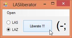
The LASliberator reads LiDAR points from closed “Optimized LAS” files that use the “.zlas” extension and converts them to open ASPRS LAS files that use the “.las” extension. Alternatively, the points can be stored to compressed LAZ files – using the open source LASzip compressor – that use the “.laz” extension. In addition, the tool creates tiny spatial indexing files that use the “.lax” extension. These can then be exploited for accelerated area-of-interest queries via open source LASindex when using LAStools or the latest version of the LASzip DLL.
The new LASliberator comes on the heels of an outcry in the community over the LiDAR format fragmentation “Optimized LAS” is creating. It provides an immediate solution to go from closed zLAS to open LAZ for people whose LiDAR got stuck in yet-another-proprietary-format.
About rapidlasso GmbH
Technology powerhouse rapidlasso GmbH specializes in efficient LiDAR processing tools that are widely known for their high productivity. They combine robust algorithms with efficient I/O and clever memory management to achieve high throughput for data sets containing billions of points. The company’s flagship product – the LAStools software suite – has deep market penetration and is heavily used in industry, government agencies, research labs, and educational institutions. Visit http://rapidlasso.com for more information