GISuser.com

GIS and Technology news for mapping professionals

  • PRESS
    • Submit PR
    • Top Press
    • Business
    • GIS, Geo Tech Software
    • Hardware
    • UAV News
    • Mobile Technology
    • Editor’s Top Picks
    • Get TOP Listing!
  • FEATURES
    • GeoGeeksinCars
    • 10 Question Q&A
    • FROM THE EDITOR
    • SPATIAL MEDIA AUTHORS
    • Social Media Features
    • EXPERTS & Guests
    • Listicles and Top 10 Lists
    • Infographics
    • VIDEOS
  • Events
    • Webinars
    • Submit event
    • Event Media Partner
  • CAREERS
    • Career Help Articles
    • People and Career News
    • Work from Home
    • About GeoJobs.BIZ
  • About
    • Advertise
      • Advertise wth GISuser
      • Media Kit Request Form
      • Directory
      • Submit Press
    • Contact GISuser
    • Meet the Editor
    • Social Media
      • AnyGeo Blog
      • GeoGeeks Podcast
      • Social Media Features
      • Like Us
    • SpatialMedia
      • LBSzone
      • LiDAR Magazine
      • Amerisurv
      • SymbianOne
    • RSS feed
  • Blog
  • Shop
  • Cloud Hosting
    • Amazon Cloud Hosting
    • WordPress cloud hosting
    • Dedicated servers USA
    • Linux Shared Hosting
    • Windows Shared Hosting
    • Web Development
    • SSL Certificate
  • Tradepubs
You are here: Home / **Front Page / View the #SOTU2015 Analytics via the Twitter Github

View the #SOTU2015 Analytics via the Twitter Github

January 21, 2015 By GISuser

I’m a fan of data, however, I’m an even bigger fan of Big Data! Enter the Twitter analytics exploring the 2015 State of the Union Address #SOTU2015

#SOTU2015 Analytics

#SOTU2015 Analytics

Via Twitter, the team has done an amazing job of archiving the data gathered during the State of the Union Address by President Obama, revealing an amazing visualization tool where you can scroll through the text of the address and see just exactly what the sentiment was and what was trending on Twitter at that exact moment – crazy!

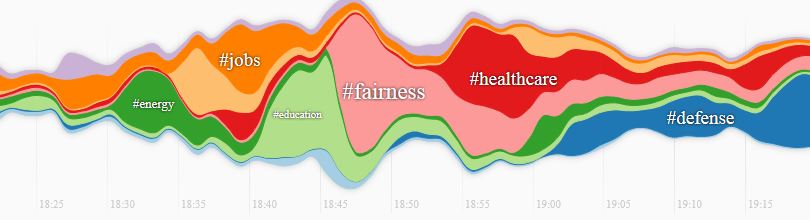
A quick look at the data reveals that BIG peaks and valleys were experienced when the topics of #education #fairness and #healthcare were discussed – obviously this is what is on the mind of Americans and topics that they are quite vocal/passionate about!

Use the resource to scroll through the speech, paragraph by paragraph and see on the timeline exactly what was trending on Twitter at that moment. Additionally, a map is provided to show which States were trending highest on certain topics.

twitter analytics for #SOTU2015

twitter analytics for #SOTU2015

Check out the #SOTU analytics HERE


See more SOTU Analytics:

  • http://stateoftheunion.onetwothree.net/
  • SOTU on the Atlantic – the Language of the SOTU

Related Articles on GISuser:

  • Social Guide – The Definitive Starting Point for Mastering your Twitter AnalyticsSocial Guide – The Definitive Starting Point for Mastering your Twitter Analytics
  • Feature: Social Media Mapping is Crucial for Market Research and your Social StrategyFeature: Social Media Mapping is Crucial for Market Research and your Social Strategy
  • Have Infographics and Data Visualizations Ruined Good Map Design?Have Infographics and Data Visualizations Ruined Good Map Design?
  • Explore The Top Twitter Trends from 2014Explore The Top Twitter Trends from 2014
  • App Tip – Slideshare adds detailed AnalyticsApp Tip – Slideshare adds detailed Analytics
  • 10 Question GeoGeek Rapidfire – Scott Carter @ScottCarterGIS10 Question GeoGeek Rapidfire – Scott Carter @ScottCarterGIS

Filed Under: **Front Page, *BLOG, *FEATURES, Around the Web, Infographics, Social Media Features, Top Press Tagged With: #sotu2015, analytics, president obama, SOTU, Twitter


Editor’s Picks

Free Data from USGS Proves Its Worth for Observing Earth

IN.gov Honored in 2014 Best of the Web Awards

Tripomatic – Custom Maps Built entirely with OpenSource Mapping Tools

Esri Helps Developers Add Geo to Apps at TechCrunch Disrupt NY 2016

See More Editor's Picks...

Connect with GISuser

  • Facebook
  • Google+
  • LinkedIn
  • RSS
  • Twitter


GIS jobs

Recent Features

Digitalization and Simulation at the North Pole

Natural Gas District & GIS-Centric Asset Management

5 Ways Technology Is Affecting The Sharing Economy

Spotlight – Township Canada: Explore Canadian Legal Land Descriptions on a Map

GeoGeeksinCars – The one in “Tippy” the right-hand drive Mitsubishi, at DevSummit

More Posts from this Category

Categories


Recent Posts

  • National Energy System Map contract awarded to 1Spatial and Ordnance Survey by The Energy Networks Association
  • DENSO Products and Services Americas Celebrates 50 Years in America
  • USGIF Board of Directors Appoints New Chair
  • Trimble Launches Dimensions Spotlight Series for 2021
  • 5 tips for successful implementation of smartphone surveillance at work

RSS Career Tips

  • Four Characteristics of the Best Virtual Employees
  • Jobcase Launches Free Unemployment Resource Center for Workers Impacted by COVID-19
  • 8 Questions Employers Should Ask About Coronavirus
  • Must-Have Gadgets and Technology for the Remote Office Worker
  • Must-Have Gadgets and Technology for the Remote Office Worker


shop for geogeek swag

RSS Tech pubs

  • Data Driven insights for Personalized Medicine
  • The Advantages of Reshoring Your Manufacturing Operation
  • Accelerating Lung Cancer diagnosis with Artificial Intelligence

RSS Computers

  • iPad CTO Kit - including the iPad Tips and Tricks Guide for IT Executives and Managers
  • The Essentials of Information Security Kit: Includes a Free PC Security Handbook - 2nd Edition eBook
  • Windows... On Speed

RSS HR Tips

  • Fiduciary of the Future
  • The IT Training Buyer's Guide & Checklist
  • Creating A Secure Remote Work Environment eBook

RSS Gov Tech

  • Next-generation Situational Awareness - How Skydio's autonomous drone solutions protect first responders
  • AI Meets Inspection: How Autonomous Drones are Changing the Game in Enterprise
  • Cyberwarfare Requires Speed, Adaptability and Visibility to Win: Enterprises Must Close the IT Operations and Security Gap

RSS UAV news

  • Global Commercial Drone Market Expected to Exceed $8.5 Billion By 2027
  • Down to Earth – Drone Lidar Surveying Reality Series Returns
  • Florida Signs Participating Addendum with DroneUp Providing Public Sector Agencies Access to Drone Services

RSS Geojobs

  • An error has occurred, which probably means the feed is down. Try again later.
Copyright Spatial Media LLC 2003 - 2015