GISuser.com

GIS and Technology news for mapping professionals

  • PRESS
    • Submit PR
    • Top Press
    • Business
    • Software
    • Hardware
    • UAV News
    • Mobile Technology
  • FEATURES
    • Around the Web
    • Social Media Features
    • EXPERTS & Guests
    • Tips
    • Infographics
  • Events
  • CAREERS
  • Advertise
    • Advertise
  • Blog
  • Shop
  • Tradepubs
You are here: Home / *FEATURES / THE EDITOR / Mobile Developer Opportunity – Open Data Means Opportunity: The Food Truck App Example Streetfoodapp

Mobile Developer Opportunity – Open Data Means Opportunity: The Food Truck App Example Streetfoodapp

May 7, 2014 By Editor

So, you wanna grab a bite to eat. Chances are good that if you live in or near a cool, hipster filled city that a food truck may be close by. Think opportunity! 


Another plug for OpenData and a subtle tip and a cool example of what you or your business might consider doing with some opendata, a mapping API, and your favorite coding tools – oh, you might need some pizza, RedBull and beer as well to help inspire you a bit!

I recently stumbled onto a cool mobile food truck app for my city (Victoria, BC) and there’s no reason why you can’t create one for your region. All you need is a little creativity, some handy mapping tools, and most important, some quality open data! Many local and regional governments now host open data portals which means that there’s a TON of data out there just waiting to be mashed up and repurposed into a handy mobile app that provides the locals with some useful information. Case in point, Streetfoodapp, a handy food truck mapping and tracking app now available for iOS and Android. The Streetfoodapp is slowly rolling out apps that are tailored to specific cities and geographic regions, to date there are apps available for Victoria and Vancouver B.C, Canada, Boston, Ottawa, Calgary, Toronto, Edmonton, Halifax and yes indeed, even Tallahassee Florida (Go Noles!!). I have to assume that the rolout of apps is based on the availability of useful data although this should be relatively easy to locate, albeit I suspect these data are locked up and distributed in a number of formats and providing a real mish-mash of variables.

Streetfoodapp is pretty simple in concept with a Google Maps driven user interface. Load the app of choice and the map is centered on your city. Food trucks are identified by green dots on the map along with helpful data showing time of operation at that location. Trucks can also be viewed in a tabular list form that also displays a user ranking by stars, open or closed designation, and distance from your current location. Finally, trucks can be sorted by popularity or listed as your favorites. View detailed info about each truck and you should see hours of operation for the week, a link to an official website, twitter, and email account. Social sharing options are also provided so you can share with your fiends and networks.

The app is simple but very effective. Can it be made better? Sure it can and that’s where you can jump in – think Opportunity!!  I’m always amazed at all the amazing business opportunities that are out there and these days, with OpenData repositories launching nearly every day there’s no shortage of data. Mapping tools, APIs, SDKs are plentiful and the downside for you developers is that the tools are getting to be easier to use, are widely available, and easily accessible to all. This means that you have a TON of competition. The traditional GIS developer has skills in mapping, database design, coding, cartography etc… skills that many "mainstream" developers may be lacking so this is where you can shine. Don’t have an idea yet? No problem, just keep your eyes open and try some of the new mobile apps that we discuss here, on social media, or on my blog and then go put your own spin on the app, make it your own and make it better.


Individual truck info is provided


View all the local food trucks by list


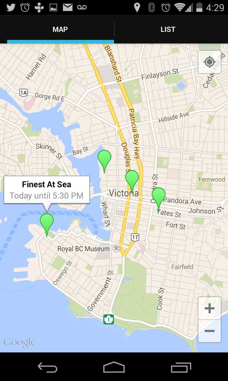
View truck locations on the map

See the streetfoodapp site and their mobile apps at http://streetfoodapp.com/

Note: Try conducting a search of your local opendata portal for business permits. Chances are good that you’ll find information and data that can be used to help launch your app. Case in point, the City of Vancouver has an entire section on their site devoted to food vendors at http://vancouver.ca/doing-business/selling-food-on-vancouver-s-streets.aspx

You may encounter many apps that are similar for various locations around the country, for example, Portland, OR, considered by many to be the food truck capital has a dedicated website with mobile apps, http://www.foodcartsportland.com/maps/ as does the city of Seattle, WA. http://www.seattle.gov/ECONOMICDEVELOPMENT/mobilefood/default.htm

Related Articles on GISuser:

  • Guest Expert – Fly to Every World Cup Stadium On the Map – With Social Media Updates! Guest Expert – Fly to Every World Cup Stadium On the Map – With Social Media Updates!
  • Infographic – The Past and Future of Drones in the U.S.Infographic – The Past and Future of Drones in the U.S.
  • Top 10 Most Wanted Municipal Datasets Identified at 2014 Open Data SummitTop 10 Most Wanted Municipal Datasets Identified at 2014 Open Data Summit
  • Time to Code Canada! The Canadian Open Data Experience (CODE) Hackathon #GCA4Time to Code Canada! The Canadian Open Data Experience (CODE) Hackathon #GCA4
  • illustreets Exemplifies the power of Open Data Enabling Anyone to Explore Englandillustreets Exemplifies the power of Open Data Enabling Anyone to Explore England
  • Dev Tip – Esri Global Disaster Resilience App Challenge 2014Dev Tip – Esri Global Disaster Resilience App Challenge 2014

Filed Under: THE EDITOR Tagged With: expert, Experts, gletham, Mobile Developer Opportunity - Grab Some OpenData and Launch your Own Food Truck App or ??, opendata, Select Category


Editor’s Picks

How Safe is Google Wallet?

How Safe is Google Wallet?

Map of the Day – TheCeliacScene, Guides for the Gluten Free

ESRIUC Notes – Top 10 new features in ArcGIS 10.2

Safe Software WEBINAR – Geospatial and Minecraft – Why You Should Care

See More Editor's Picks...

About Editor

Glenn is a geographer and a GIS professional with over 20 years experience in the industry. He's the co-founder of GISuser and several other technology web publications.

Feed

  • RSS


GIS jobs


Recent Features

Digitalization and Simulation at the North Pole

Natural Gas District & GIS-Centric Asset Management

5 Ways Technology Is Affecting The Sharing Economy

Spotlight – Township Canada: Explore Canadian Legal Land Descriptions on a Map

GeoGeeksinCars – The one in “Tippy” the right-hand drive Mitsubishi, at DevSummit

More Posts from this Category

Categories

Recent Posts

  • SAIC Selected for $390 Million Task Order to Provide Systems Engineering and Integration Services To U.S. Space Force
  • Collitigating: Process of Suing A Commercial Company In A Car Accident
  • Bitcoin Rises 8% in a Day After U.S. Government Announces Cryptocurrency Executive Order
  • U.S. Treasury Alerts Banks about Russian Government & Oligarchs Using Cryptocurrency to Overcome Sanctions
  • How Does Orgone Energy Work

RSS Career Tips

  • Four Characteristics of the Best Virtual Employees
  • 8 Questions Employers Should Ask About Coronavirus
  • Jobcase Launches Free Unemployment Resource Center for Workers Impacted by COVID-19
  • Must-Have Gadgets and Technology for the Remote Office Worker
  • Must-Have Gadgets and Technology for the Remote Office Worker


shop for geogeek swag

RSS Tech pubs

  • The Next Tech Revolution: What Your Business Needs To Know To Stay Ahead
  • Delivering in a Post-Pandemic World
  • Privacy Anywhere, Security Everywhere

RSS Computers

  • HackerProof: Your Guide to PC Security
  • Windows... On Speed
  • The Idiot's Ultimate Guide to Build Your Own PC

RSS HR Tips

  • Learn to Optimize High-Volume Recruitment Planning
  • 2022 Restaurant & Retail Talent Acquisition Predictions Report
  • Talroo's 2022 Complete Restaurant Hiring Playbook

RSS Gov Tech

  • Flexibility, Work-Life Balance, and Job Satisfaction: Why More Lawyers Are Seeking Career Alternatives
  • Clio: Guide to Law Office Automation
  • The 11 Habits of Highly Successful Law Firms

RSS UAV news

  • UAS Drone Subsidiary, Duke Robotics’, Sniper Drone showcased at a leading International Airshow in the Asia Pacific Region
  • Short Battery Life: A Drone’s Worst Enemy
  • UMAV ANNOUNCES ITS LIGHTER THAN AIR DETACHABLE DRONE IS COMPLETING FINAL AVIONICS INSTALLATION

RSS Geojobs

  • Help Desk Technician
Copyright Spatial Media LLC 2003 - 2015