GIS user technology news

News, Business, AI, Technology, IOS, Android, Google, Mobile, GIS, Crypto Currency, Economics

  • Advertising & Sponsored Posts
    • Advertising & Sponsored Posts
    • Submit Press
  • PRESS
    • Submit PR
    • Top Press
    • Business
    • Software
    • Hardware
    • UAV News
    • Mobile Technology
  • FEATURES
    • Around the Web
    • Social Media Features
    • EXPERTS & Guests
    • Tips
    • Infographics
  • Blog
  • Events
  • Shop
  • Tradepubs
  • CAREERS
You are here: Home / Blog / colorado / MyWaytogo Trip Planning Tool from DRCOG for Denver, Colorado Commuters

MyWaytogo Trip Planning Tool from DRCOG for Denver, Colorado Commuters

January 29, 2014 By Editor

A clever new trip planning tool is available to commuters in the Denver, Colorado area from DRCOG – enter Mywaytogo. The one-stop shop that allows commuters to easily and comprehensively compare their trip options and make informed choices. Users can simply enter their trip information to quickly see their commute options and compare travel time, distance, cost, and health benefits, including calories burned and such environmental impacts as CO2 generated.

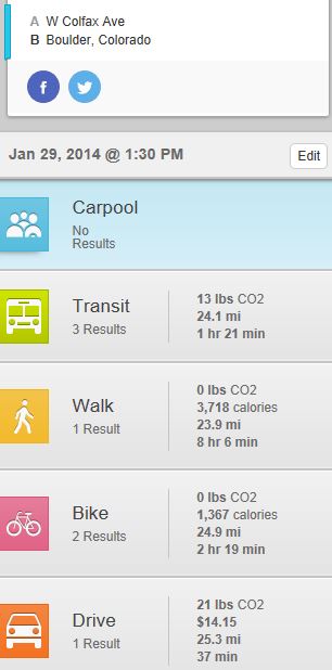
The results show in the graphic below show a sample output search from Denver to Boulder and provides the user with information, times, and data for the commute by carpool, drive, bike, and walk. In addition to travel times we also see CO2 values, cost, and distance.. very nice!

See more in the official announcement or try the service at http://mywaytogo.org/

Filed Under: colorado, conservation, Environment, THE EDITOR Tagged With: blog, Colorado

Editor’s Picks

Data Tip – The US Interagency Elevation Inventory

DigitalGlobe Satellite Captures Dramatic Images of Alberta, Canada Oil Sands wildfire #fmmfire

Google Announces that Google Earth Pro is now free

Geospago and what3words partner to provide a mobile mapping solution with 3-word addressing throughout the globe

See More Editor's Picks...

About Editor

Glenn is a geographer and a GIS professional with over 20 years experience in the industry. He's the co-founder of GISuser and several other technology web publications.

Recent Industry News

Aerial Surveys Int’l and Global Marketing Insights to Present GEOINT 2026 Workshop on Multi-Domain Geospatial Fusion for Automated Infrastructure Monitoring

April 24, 2026 By GISuser

Why Timing Matters More Than You Think With Spray Seal (And Why People Often Get It Slightly Wrong)

April 22, 2026 By GISuser

The Quiet Planning Stage Most People Don’t See When Building a Pool in Brisbane

April 22, 2026 By GISuser

Best Equipment Labels for Industrial Use: Ranked Systems That Survive Real-World Conditions

April 17, 2026 By GISuser

Hot News

State of Data Science Report – AI and Open Source at Work

HERE and AWS Collaborate on New HERE AI Mapping Solutions

Virtual Surveyor Adds Productivity Tools to Mid-Level Smart Drone Surveying Software Plan

Categories

Copyright gletham Communications 2015 - 2026

Go to mobile version