GIS user technology news

News, Business, AI, Technology, IOS, Android, Google, Mobile, GIS, Crypto Currency, Economics

  • Advertising & Sponsored Posts
    • Advertising & Sponsored Posts
    • Submit Press
  • PRESS
    • Submit PR
    • Top Press
    • Business
    • Software
    • Hardware
    • UAV News
    • Mobile Technology
  • FEATURES
    • Around the Web
    • Social Media Features
    • EXPERTS & Guests
    • Tips
    • Infographics
  • Blog
  • Events
  • Shop
  • Tradepubs
  • CAREERS
You are here: Home / News / GIS, Geo Tech Software / GIS Applications – Chiayi Travel Guide App

GIS Applications – Chiayi Travel Guide App

December 11, 2013 By Editor

To promote business opportunity of local industries, tourism and creative souvenirs in Chiayi, this project focuses on special stores, vintage factories and aged stores and includes culture related elements such as festival, handicraft souvenirs, agricultural products and specialties.

This project is planned to assist local special aged stores that match specified conditions and have willingness in restructuring styles through gathering coordinates of stores, executing Nearest Neighbor Analysis and utilizing spatial data to emphasize culture of traditional industry and promote special industry in the city. In addition, a website and

Chiayi Travel Guide App
smart phone Apps are developed and built to import human resource education, construction of aesthetics for life space, new technologies and creative marketing methods for increasing job opportunities in Chiayi and stimulating local economy.
 
Goals

The plan contains establishment of a website and development of two iOS Apps.

The website is composed of a front-end platform and a back-end platform. The back-end platform is built for data uploading and managing usage; hence, administrator can upload and manage data on the back-end platform. And the edited and audited data will be shown on the front-end platform for browse and query. In addition, this plan also provides Apps for tourists to download and install on smart phone with iOS system. Tourists can utilize the two Apps to comprehend information about Chiayi, plan the route and enrich quality of their trips.

 
Solutions

Website:
Address Locator on SuperGIS Online service is employed to position local stores. Besides, the front-end and back-end platforms of the website are built with ASP.NET. And the database is established with Microsoft SQL Server 2008 R2 in the mean time.

APP:
The development of the two Apps integrates PR (Pattern Recognition) and AR (Augmented Reality) technologies respectively. In addition, Google Maps are adopted as the basemap to diversify and facilitate utility of Apps’ functions.

 
Results

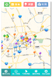
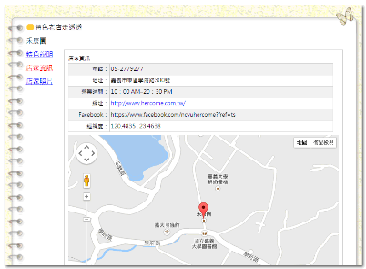
Front-end and back-end platforms of the website named “Singfu Dear Chia” and two iOS Apps are built, developed and launched to assist Chiayi City Government in promoting local tourist attractions, and provide tourists with tourism information of Chiayi. With the website and the Apps, tourists can easily obtain information of Chiayi, make tour plans and enjoy their trips.

Website:
Front-end and back-end platforms are built to assist administrators and users in executing different tasks.

The Back-end Platform:
The back-end platform is built for data uploading and managing usage; hence, administrator can upload the collected information of tour attractions and stores to the database by referring to categories on the manipulation interface. And after being audited, the uploaded information will be shown on the front-end platform for browse and query.

The Front-end Platform:
On the front-end platform, users can choose to browse the interface in Chinese, Japanese or English. Main pages on the website include “Brief of Project Introduction”, “News”, “Unique Aged Stores”, “Multiple Media”, “Tour Information Download”, “Hanging out in Chiayi City” and “Local Souvenirs.” On pages of “Unique Aged Stores” and “Hanging out in Chiayi City”, Google Maps are employed to deliver users’ query results on the interface. With key word query, full-text search and the query result on the map, users can get related information and create their tours with ease.

In “Unique Aged Stores” store types are categorized. Users can search store information with key words. Also, users can browse the map that adopts Google Maps as the basemap and quickly find the store information and location with the map.

In addition, various popular tour routes, destinations and stores recommended on the website are displayed on the map. Users cab click on the symbols standing of tourist attractions or stores to view related data read from database. As a result, users can plan their tours more smoothly through getting related local information quickly.
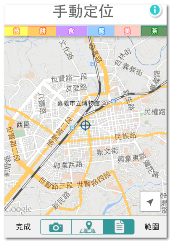
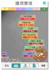
 

App:
Two versions including“Singfu Dear Chia” and “Singfu Dear Chia (AR)” are provided for iOS platform.

“Singfu Dear Chia (AR)” Version:
Augmented Reality is employed; therefore, users can browse locations of stores nearby on screen of iPhone or iPad. The system displays the distance among stores and the store names according to coordinates of stores. Additionally, a radar chart is shown in the lower-right corner of the interface for viewing the distribution of stores, hence, users can see the searched (stores) more easily.

In “Sinfu Dear Chia (AR)” App, three methods including “Augmented Reality”, “Map Viewing” and “Store List” for searching stores are provided. Each method must work with GPS positioning system. Users can set the number of data records and the search range. In addition to “Automatic Positioning” option, the “Manual Positioning” mode is also provided to simulate users’ locations while no GPS signal is received. After setting search conditions above, users can view the related information on the map displayed on their devices.


Manually Positioning
Augmented Reality

"Singfu Dear Chia” Version:
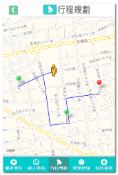
The main functions of this application include “Specialists Lead the Way”, “Nearby Tourist Attractions” and “Itinerary Plan.” Users also two options of positioning modes to position themselves. Either “Automatic Positioning” or “Manual Positioning” can be chose to assist users in positioning themselves and reading information of tourist attractions and stores form database. Users can switch viewing modes among “List”, “Resume” and “Map” to view information of nearby stores. Coupled with spatial analysis technology, the application lists specified stores in order based on the distance among these tourist attractions, stores and users. Moreover, on page of “Itinerary Plan”, users can filter stores according to conditions like travel time, distance, type, indoor or outdoor environment. Stores matching conditions will be listed on the map according to the distance among stores and the user. Users can check stores they intend to visit to plan itinerary, the itinerary routes will be shown on the map afterwards.

Attractions on the map
Route planning

Effects:
Integrating with information of local tourist attractions and stores and map display, “Chiayi Travel Guide App” allows users to use various functions like querying tourist attractions around, searching recommended stores and etc directly; and the app does promote local features and dissemination of local tourism effectively.

Employing Google Maps as the basemap to display locations of local stores, “Chiayi Travel Guide App” also adopts Google Map API to plan routes. In days to come, to have the plan result match the real-time environment, SuperGIS Network Server is considered to be adopted for integrating network analysis expression function and assisting administrators in maintaining network data through management tools. In addition, App for Android is also anticipated for Android users.


Filed Under: GIS, Geo Tech Software Tagged With: Geo Tech Software, GIS, GIS Applications - Chiayi Travel Guide App, News

Editor’s Picks

GIS and History: Using the Past to Inform the Present

Social Media is an Increasingly Important Part of Webmaps, Data Analysis, Analytics and Visualizations

Microsoft unveils the future of Windows

Avenza Releases MAPublisher 9.7 for Adobe Illustrator

See More Editor's Picks...

About Editor

Glenn is a geographer and a GIS professional with over 20 years experience in the industry. He's the co-founder of GISuser and several other technology web publications.

Recent Industry News

How to Choose the Best Office Interior Designers in Delhi for End-to-End Projects

June 3, 2026 By GISuser

Why Bathroom Renovation Services Often Change More Than Just the Bathroom

May 20, 2026 By GISuser

The Drift Between Early Notes and Final Case Files in Abuse-Related Legal Support

April 29, 2026 By GISuser

Aerial Surveys Int’l and Global Marketing Insights to Present GEOINT 2026 Workshop on Multi-Domain Geospatial Fusion for Automated Infrastructure Monitoring

April 24, 2026 By GISuser

Hot News

State of Data Science Report – AI and Open Source at Work

HERE and AWS Collaborate on New HERE AI Mapping Solutions

Virtual Surveyor Adds Productivity Tools to Mid-Level Smart Drone Surveying Software Plan

Categories

Copyright gletham Communications 2015 - 2026

Go to mobile version