GIS user technology news

News, Business, AI, Technology, IOS, Android, Google, Mobile, GIS, Crypto Currency, Economics

  • Advertising & Sponsored Posts
    • Advertising & Sponsored Posts
    • Submit Press
  • PRESS
    • Submit PR
    • Top Press
    • Business
    • Software
    • Hardware
    • UAV News
    • Mobile Technology
  • FEATURES
    • Around the Web
    • Social Media Features
    • EXPERTS & Guests
    • Tips
    • Infographics
  • Blog
  • Events
  • Shop
  • Tradepubs
  • CAREERS
You are here: Home / Blog / conservation / Chicago Real Time Bike Accident Map Identifies Hot Spots

Chicago Real Time Bike Accident Map Identifies Hot Spots

August 2, 2013 By Editor

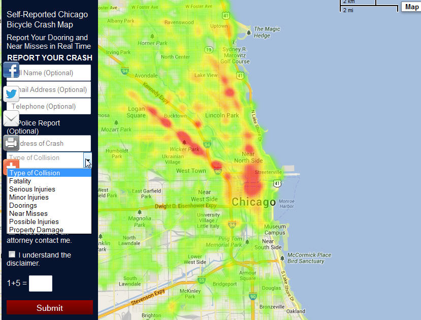
An interesting effort in Chicago by a law firm who have made available a pretty sweet map that enables cyclists to report accidents in order to define hot spots within the city.  This interactive map will allow users to report, not only bicycle accidents and doorings , but close calls or near misses as well, all in real time. Additionally, by reporting the type of collision, weather, lighting and surface conditions during the accident or close-to accident, we will be able to have more data about bicycle accidents, when they occur, where they occur, and how to prevent them.

Visit: http://www.willenslaw.com/report-your-accident

See more info about the map HERE

Filed Under: conservation, environment, Environment

Editor’s Picks

OpenAerialMap – The open collection of aerial imagery

A Milestone in the Digital Mapping Industry: Avenza’s PDF Maps App Surpasses One Million Downloads

Social Guide – The Definitive Starting Point for Mastering your Twitter Analytics

DigitalGlobe Top Images from 2014 – The fourth annual Top Image contest

See More Editor's Picks...

About Editor

Glenn is a geographer and a GIS professional with over 20 years experience in the industry. He's the co-founder of GISuser and several other technology web publications.

Recent Industry News

Aerial Surveys Int’l and Global Marketing Insights to Present GEOINT 2026 Workshop on Multi-Domain Geospatial Fusion for Automated Infrastructure Monitoring

April 24, 2026 By GISuser

Why Timing Matters More Than You Think With Spray Seal (And Why People Often Get It Slightly Wrong)

April 22, 2026 By GISuser

The Quiet Planning Stage Most People Don’t See When Building a Pool in Brisbane

April 22, 2026 By GISuser

Best Equipment Labels for Industrial Use: Ranked Systems That Survive Real-World Conditions

April 17, 2026 By GISuser

Hot News

State of Data Science Report – AI and Open Source at Work

HERE and AWS Collaborate on New HERE AI Mapping Solutions

Virtual Surveyor Adds Productivity Tools to Mid-Level Smart Drone Surveying Software Plan

Categories

Copyright gletham Communications 2015 - 2026

Go to mobile version