Scenario
To provide citizens, governments, academic institutions in Taiwan to obtain the spatial data and web services and integrate and apply the data with ease, Ministry of the Interior, ROC (Taiwan) planned to promote “TGOS Cloud Development Plan.” The perspective of TGOS Cloud is to collect, store, and process the spatial data from government departments and to publish diverse APIs (e.g., TGOS MAP API) that can be applied by every government organization to integrate with their data. Therefore, the platform can reduce the cost of the repeated system service in government organizations and effectively improve the efficiency of map website development.
Goals
TGOS Cloud is supposed to perfectly integrate the membership database, spatial data browsing authority, data applying, service registration management, etc). Additionally, to enable citizens, government departments and general institutions to integrate the spatial data, the data should be processed and served as APIs on TGOS platform.
Solutions
To seamlessly integrate various types of spatial data and publish the data as diverse services, TGOS Cloud adopts SuperGIS Server 3 as server software of its platform which is capable of integrating and publishing the spatial data as various types (e.g., map service, feature service, OGC service) and unifying map tile types to reduce man power and cost of every department in preparing spatial data. Besides, the services published by SuperGIS Server can be overlaid with the services of the existing platforms and applied through Map API. Therefore, the organizations requiring maps are able to apply map API and develop mobile applications easily and economically.
Results
TGOS Cloud is an online service, which is connected to Servers, provides end-users to query for data or utilize for application with pre-generated base maps. SuperGIS Server served as the back-end server for TGOS MAP API and Network service. Users can connect with the server and apply the TGOS MAP API to develop their own map services, integrating with all the available data in TGOS database, applied to not only for web applications, but also in mobile systems.
Framework and Key Features of SuperGIS Server
1. Parallel SuperGIS Servers compose TGOS Cloud System for TGOS MAP API and Network Service:
The framework of SuperGIS Server in TGOS Cloud System is: parallel SuperGIS Servers can be regarded as one group, which provides services simultaneously and can be connected to one another. Therefore, the data stored in the back-end database can be used for different services at the same time and updated right away. In SuperGIS Servers, the loading for each server will be controlled to reach a balance among one another.
2. One cluster, composed of one to several SuperGIS Servers, can be assigned to a specific service:
Under the framework, SuperGIS Server provides services by clusters. One cluster can be composed of one to several SuperGIS Servers. Each cluster will be assigned to provide a specific service; eg: the geoprocessing service may need more computer resources; therefore, at least two SuperGIS Servers will compose as one cluster to process the request from end-users. The loading between every SuperGIS Server in one cluster will also be well-controlled to reach the balance.
3. Virtual machines can be launched once the demand on request increases:
In TGOS Cloud System, SuperGIS Server also includes other 4 flexible virtual machines. Once requests from end-users increase, the corresponding virtual machine for specific service can be launched to start processing the requests to prevent the overload issue. At the time when the requests lessen, the virtual machine can be closed to reduce the waste of resource.
TGOS Map API
TGOS MAP API is based on JavaScript, having the compatibility for most web browsers. The services from TGOS MAP API can be classified into 5 categories: the basic and advanced elements for web-controllers, stacking for map elements, data structures, and other located services. Users can apply the map platform and API services on TGOS to utilize the commonly-used essential base maps and manipulation tools to display the map data. TGOS Map API include web API and mobile API so that users can apply the API, like map overlay, query, measurement, etc. to build their own applications for different platforms.
Furthermore, TGOS Map API can also help different departments and organizations to build the platforms for specific purposes, like disaster prevention, land use planning, etc. The platform can apply the base map tiles from Map API and overlay their own theme maps to efficiently build up a professional theme platform.
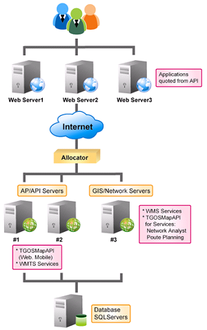
the basic framework of SuperGIS Server in TGOS Cloud System
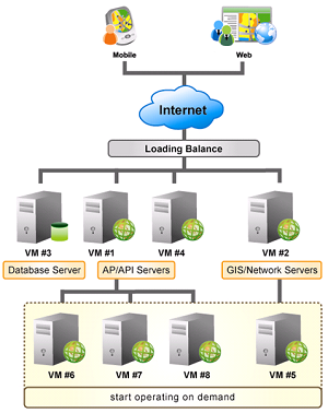
the clusters and virtual machine of SuperGIS Server in the framework of TGOS Cloud
Centers for Disease Control (CDC) in Taiwan R.O.C applied the TGOS MAP API for querying the sources of vector mosquitoes
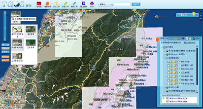
TGOS Map Platform displays the mineral storages and natural resources in Taiwan, based on TGOS MAP API.
System Benefit:
The establishment TGOS Cloud is capable of integrating and publishing spatial data as diverse services. In addition, the organizations that require map data can apply Map API provided by TGOS Cloud to conduct various analyses like route analysis, buffer, etc., and meet the requirements of map website effectively without spending cost of saving and publishing maps.