Trimble Floodlight satellite shadow reduction technology enables St. Charles Parish Waterworks crews to maintain productivity in all mapping environments
n an effort to improve the accuracy of its GIS maps, St. Charles Parish, La., purchased its own GNSS equipment. The parish Waterworks Department experienced outstanding results when mapping water infrastructure features-except when working beneath the parish’s towering oak trees, which deflected or blocked GNSS satellite signals. The parish upgraded to the Trimbler GeoExplorerr 6000 series of mapping GNSS handhelds with Trimble FloodlightT technology and saw an immediate improvement in productivity and accuracy.
PROJECT DATE: Deployed in 2011 – The last straw for St. Charles Parish, La., came when an underground water pipeline burst beneath a busy street. Traffic had to be diverted as the water continued to spill out onto the pavement. A half hour passed, and then another, before personnel from the Waterworks Department found the shutoff valve and stopped the deluge. The delay was caused by a faulty map that incorrectly showed the valve’s location on the other side of the street.
As is true for many local government departments, the St. Charles Waterworks relied on as-built drawings and sketches supplied by developers and engineering firms to keep the network of underground water pipes updated in its GIS. At the time, the parish had no other option because it lacked internal mapping capabilities.
In 2008, St. Charles created a GIS Office to support mapping needs of all other parish departments and hired Luis Martinez to manage it. Fortunately, Martinez had been trained to use GNSS technology for GIS data collection in his previous position. He convinced the parish it would be cost-effective to invest in mapping- and survey-grade GNSS equipment and train personnel to use it as part of their daily operations.
 "The first personnel we trained were the Waterworks and Public Works crews," said Martinez.
He explained that Waterworks is responsible for maintaining, repairing and upgrading the parish’s network of above- and below-ground water pipelines. Public Works manages the storm protection and drainage infrastructure, such as catch basins, ditches, and levees. Trimble Floodlight Boosts Productivity The GIS Office maintains a parish-wide, Internet-accessible GIS comprised of layers for nearly all departments. Aside from Public Works, the Waterworks Department has the most rapidly evolving geospatial data layers in the parish. With new water pipes being installed or old ones being replaced, the Waterworks infrastructure map is constantly in flux. Handheld GNSS-based GIS data collection units were seen as the ideal solution keeping layers accurate and up to date.
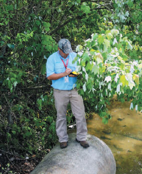
Waterworks crews experienced problems with accuracy when working beneath the stately oak trees that line many parish residential streets. The oak canopies deflect and partially block GNSS signals from reaching the receivers, impairing productivity through a phenomenon called satellite shadow. This same signal deflection problem often faces mapping crews working among tall buildings in many cities. Martinez quickly identified the satellite shadow problem and upgraded the parish GNSS equipment to the Trimble GeoExplorer 6000 series. These handheld GIS mapping devices come equipped with the unique Trimble Floodlight capability that overcomes the productivity-reducing effects of satellite shadow without sacrificing accuracy. The technology accomplishes this through a combination of multi-constellation (GPS and GLONASS) positioning, advanced tracking algorithms, and altitude-constrained positioning.
Waterworks personnel onsite at every excavation project began using Trimble GeoExplorer 6000 GeoXHT handhelds running Esri ArcPad data collection software. As new pipe is laid in the ground, the handheld devices are used to map the location and depth with submeter accuracy before it is buried. Crews use pull-down Esri ArcPad menus on the touch screen to collect key descriptive data relating to each asset, such as the size and composition of the conduit. Additionally, locations of other important items such as shut-off valves are mapped onto the GIS layer with the same precision.
"Before Floodlight, we could only get a strong signal from about six satellites, depending on the canopy," said Martinez. "[Even with differential correction,] only 60 percent of our points achieved the desired 15 cm / 6 inch accuracy, while the majority of the rest were off by as much as three feet or more." Today, Waterworks crews routinely lock onto 12-13 satellites and achieve 15 cm / 6 inch accuracy for 85 to 90 percent of all points in feature mapping projects with the Trimble GeoExplorer 6000 handheld. In the field, they use a Bluetoothr connection and cell phone to access differential correction points published on the Internet by a local continuously operating reference station (CORS). Points are corrected in real time with Trimble GPScorrectT extension for Esri ArcPad software running on the handheld.
"Floodlight allows us to maintain mapping accuracy," explained Martinez, "and it pays for itself by saving time for field crews. Without the technology, crews had to measure offset positions to get out from under the trees." This wasn’t necessary once they obtained the Trimble GeoExplorer 6000 handhelds. Martinez said that measuring an offset could take two to five extra minutes to collect a single position, compared to just 15 seconds when occupying the feature itself. In addition, Floodlight technology allows the receiver to maintain satellite lock when it is put back in the vehicle for the drive to the next collection point. This also shaves several more minutes off each point collection.
"Waterworks is so pleased with the GeoExplorer 6000s that they plan to buy two just for their department," said Martinez. "They will integrate the mapping units with electromagnetic line-locating devices to map the pipes already buried underground." The St. Charles GIS has never been more up-to-date and information rich than it is now. But Martinez sees room to grow and is considering expanding the use of Trimble GIS mapping equipment to other departments, including Planning and Zoning. Inspectors from this department will soon carry integrated GIS mapping devices that enable them to document code violations in writing with timeand location-stamped photographs
EQUIPMENT USED ON THESE PROJECTs INCLUDES:
PROJECT HIGHLIGHTS
|