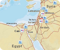
A new social media mapping service from Esri for the Middle east enables users to track social media activity from the region.
The Esri Middle East Protests Map can be used to investigate content in areas of unrest being shared via YouTube, Twitter, and Flickr. Hover over each social site name to open a keyword search to filter for topics. Use the dynamic map display tools to zoom in, zoom out, or click and drag on the map to pan left or right. Choice of backgrounds include street map, satellite imagery, or a topographic map.
The map is based on the ArcGIS API for JavaScript. Jump to the map service HERE or read more information from Esri HERE
Esri Middle East Protest Map
Originally uploaded by @gletham GIS, Social, Mobile Tech Images
