 A GISuser.com feature contribution from the Editor of The American Surveyor Magazine – Marc Cheves recently interviewed EarthData chairman and CEO Bryan Logan at EarthData’s new office complex in Frederick, Maryland, and thought that readers might enjoy a bit of information about the man behind the company.
“The aeroplane has unveiled for us the true face of the earth, wrote French aviator Antoine de Saint-Exupéry in his book Wind, Sand, and Stars, published in 1939. Decades later, the combination of “aeroplane” and photogrammetry created an exciting new method with which to map large areas of that “face” both rapidly and cost-effectively. Taking this technology ny that has implemented a myriad of new technologies to better view and map the earth. With today’s added challenges presented by homeland security, EarthData is poised to make this information available faster than ever before.
 This piece was originally published in The American Surveyor Magazine. Click Here to view the high-res, PDF version of this article.
 The 55-year-old Logan hails from Coleraine, Northern Ireland. He studied engineering at Coleraine Technical College in the late 1960s. Around this time, BKS Surveys—a surveying and aerial mapping company based outside of London, England— opened an office in Coleraine to take advantage of the money being poured into the UK’s motorway equivalent of our interstate highway system. BKS found a well-educated workforce in Coleraine and eventually moved its entire operation there, where it remains to this day. Logan began an apprenticeship at BKS in 1968.
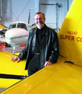
Bryan Logan standing by EarthData’s Helio Super Courier. In the background is one of EarthData’s three Piper Navaho Chieftains. The Courier will fly as slow as 55mph, and it can fly very low, so it is used for ultrahigh detail aerial photogrammetry. The Pipers are used for lidar and more traditional aerial imaging projects. The contrast between the two aircraft illustrates EarthData’s adventurous nature: it is willing to try something new if it can add more deliverables to its product palette.
In the early 1970s, Logan transferred to the company’s London office and then to the BKS office in the United States. In 1976, he traveled to the Middle East, and opened four offices in four years to support large oil and infrastructure projects. These projects involved ground surveys and photogrammetric mapping at scales sometimes as large as 1″= 20′. He reminisced about the vast, untamed nature of the region. Surveyors had to start from scratch by pouring large concrete monuments (2 meters high and 1 meter square at the base) in the desert. He chuckled as he recalled surveyors naming the monuments—one was called “Pepsi Can Hill” because they found a Pepsi can nearby. They did a lot of geodetic surveying, using T-3s and Geodimeters.
In 1980, following numerous projects in the Middle East and Africa, Logan was named managing director of BKS. Over the next four years BKS implemented the first digital mapping techniques. With new, smaller computers, technicians moved away from pantographs and scribing, to onscreen collection, review, and editing. He laughed when he recalled that a 25Mb hard drive was considered enormous capacity. BKS was a leader in digital mapping, and “did it all,” from flying to final field editing of the maps. The company more than tripled its exports and won the 1983 Queen’s Award to Industry for Export Achievement, the most prestigious honor a British company can receive.
In 1984 at an industry conference in the U.S., Logan ran into Richard Crouse, a colleague he first met in the early 1970s. Crouse had founded a small photo lab and mapping company in 1955—Photo Science—in Maryland. Crouse wanted to retire and turn his company over to someone who would take his successful business into the digital era. And so, at age 35, Logan became the owner of Photo Science. He began a 20-year transformation of the company, made possible by the concurrent revolutions in digital and remote sensing technologies. As a reflection of the impact of these revolutions on the company’s products and services, in 1997, Logan changed the company name to EarthData.
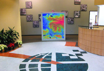
(Foyer of EarthData’s new office complex in Frederick, Maryland.) Logan’s purchase of Photo Science fortuitously coincided with the boom in computing power, which effectively moved the center of innovation in mapping from Europe to North America and fueled the expansion of the GIS profession. Logan called attention to three developments that converged to create the vast changes that have taken place in photogrammetry and aerial sensing. First, the sensors themselves. He first worked with airborne lidar in 1985, and chuckled as he recalled that they could easily do profiles, but didn’t know where the profiles were because they did not know the position or orientation of the sensor. These problems were overcome by the second innova- tion—GPS. Those were the early days of “GPS in the plane” as the early adopters mounted GPS antennas all over the plane. A third innovation— modern inertial measurement units (IMUs)—streamlined the operation. With inertial capability, a plane only needed one GPS antenna combined with an IMU to record all six elements of positioning: x, y, and z, and roll, pitch and yaw (the six degrees of freedom). Logan emphasized, however, that surveying is still needed to provide ground control. To this day, ground control is a crucial element in all the work EarthData does because it provides critical quality assurance.
EarthData was one of the first commercial firms to put GPS in the plane, and Logan credits Steve DeLoach—who had researched GPS at the Army Corps of Engineers Topographic Engineering Center in Virginia—with the company’s rapid mastery of this new technology. eginning in the early 1990s, Logan felt that Bthe company needed to expand from being solely a photography-based mapping company to offer more kinds of solutions to its clients. The company began focusing on the collection of aerial data of all kinds. Because no one sensor does it all, whether working in highly urbanized areas or in triple-canopy wilderness, EarthData’s approach is to employ a “rainbow” of sensors, and also to exploit the overlap between the various sensors. The company’s radar, for example, is excellent for foliage penetration and mapping large areas quickly, but lidar is preferable in urban areas because of its more precise beam. Logan enthusiastically described one of the latest innovations, Digital Surface Models (DSMs) developed directly from digital aerial camera images. He said the DSM hard surface product is comparable to that derived from lidar, but it gives the further advantage of its ability to see into most corners of very dense urban landscapes.
Early on, Logan positioned the company to capitalize on government outsourcing, winning contracts from the U.S. Geological Survey and the U.S. Army Corps of Engineers. To expand capacity and the company’s presence in regional markets, the company purchased Piedmont Aerial Surveys (now EarthData of North Carolina), directing its growth and expansion in the Southeast while expanding Aero Contractors (now EarthData Aviation) into one of the industry’s most technologically advanced data collection organizations with six aircraft and multiple aerial sensors. EarthData also has an office in Florida, as well as affiliations with Horizons, Inc., based in Rapid City, South Dakota, and Towill, Inc., a San Francisco-based firm. Both companies provide full-service photogrammetric and GIS products.
Ironically, the company’s greatest competitive challenge came from the organization’s largest client, the federal government. In the late 1980s many government agencies realized that by outsourcing mapping work to the private sector, they could benefit from the rapid technological innovation occurring in the industry. Logan noted that mapping professionals transitioning 
The new office in Frederick has massive data processing capability. This was necessary, since the new sensors can yield terrabytes of data in just a few days. These capabilities make it possible for EarthData to put the deliverables in the clients’ hands within days (when necessary) instead of the traditional weeks or months. Because digitally processed data is not labor-intensive as it once was, consumers no longer have to settle for data that is sometimes two years old, or data that meets 80 percent of the need. Instead they get data that is two weeks old that often meets 100 percent of the need. Upper left: Silicon Graphics racks. Lower left: Racks of Ampex tape backups.
EarthData International from government to the private sector have become an important part in this trend. He believes that government agencies could benefit further by contracting out even more work to the private sector, but stated that it will take another few years for all agencies to see the advantages. Logan served as President of The Management Association for Private Photogrammetric Surveyors (MAPPS) from 1993 to 1995. MAPPS long has advocated government outsourcing of mapping and surveying. Logan also serves on the board of directors of the Spatial Technologies Industry Association. Recognizing that technology development in the midst of day-to-day production operations is disruptive, Logan created EarthData Technologies. This separate business unit focuses on the innovation or improvement of remote sensing or data processing technologies, and introduces them in a rapid but orderly manner into production operations. Logan considers this a crucial activity given the acceleration of technological change in remote sensing and mapping, and notes that today, a company needs to be prepared to incorporate new technological methods into its processing operations on an ongoing basis rather than every five years or so.

Interior shots of EarthData’s new office complex in Frederick, Maryland.
EarthData clients reap the benefits of rapid technological enhancements as they receive a greater variety of data more quickly. As an example Logan cites EarthData’s work at the World Trade Center after 9/11. The government agencies involved in the recovery effort initially requested a turnaround time of 24 hours between data collection and delivery, but by the time EarthData had finished its 50 flights over the site, the company had shaved the delivery time to 8-10 hours. Following Hurricane Isabel, EarthData supported the USGS/ FEMA effort by mapping 27 counties in North Carolina in four weeks at 1″= 200′. Even so, the agencies want more data, and faster. ogan spoke proudly of EarthData’s involvement in Lthe new Airborne Rapid Imaging for Emergency Support (ARIES) program. This program, which is being managed by the Office of Domestic Preparedness of the Department of Homeland Security, will include mobile self-contained 10-seat command centers to rapidly respond to emergencies. The airborne platform will include lidar, imaging, and thermal sensors, and will downlink directly from the plane to the command center. The first demonstration of this program will take place in the third quarter of 2004. In April of 2003, EarthData purchased ISTAR Americas, Inc., a subsidiary of ISTAR SA, a French company whose technology improves orthophoto mapping by, simply put, eliminating building lean. We also discussed GeoSAR, a dualband interferometric radar mapping system mounted on a Gulfstream jet that is capable of mapping hundreds of square kilometers in a very short time. (Note: These impressive technologies will be the subject of a future article in The American Surveyor).
Logan has a keen business sense and has surrounded himself with knowledgeable people on both the technical and financial sides. He has the spirit of adventure, and has consistently invested in technology—both off-the-shelf and home- grown—ahead of his competitors. He was early into both digital imagery and lidar, yet he retains an extremely well operated set of film cameras. The vision that Bryan Logan mapped out in the 1980s has come into focus. In 18 years, he has grown the organization from a $1 million, 19-person regional mapping company to a $40 million, 180-person international leader in geospatial technologies. And Logan is still dreaming. He envisions a time when final data map products will stream from the plane while it’s still in the air. He laughs and says, “When this real-time capability is an actuality, then I can retire.”
Marc Cheves is Editor of The American Surveyor Magazine (www.TheAmericanSurveyor.com). Displayed with permission, The American Surveyor Charter Issue – Copyright 2004 Cheves Media.
Suggested Weblinks:
