GIS user technology news

News, Business, AI, Technology, IOS, Android, Google, Mobile, GIS, Crypto Currency, Economics

  • Advertising & Sponsored Posts
    • Advertising & Sponsored Posts
    • Submit Press
  • PRESS
    • Submit PR
    • Top Press
    • Business
    • Software
    • Hardware
    • UAV News
    • Mobile Technology
  • FEATURES
    • Around the Web
    • Social Media Features
    • EXPERTS & Guests
    • Tips
    • Infographics
  • Blog
  • Events
  • Shop
  • Tradepubs
  • CAREERS
You are here: Home / *BLOG / Around the Web / Cool Tech! TerraPattern, open-source tool for discovering “patterns of interest”

Cool Tech! TerraPattern, open-source tool for discovering “patterns of interest”

May 31, 2016 By GISuser

Here’s some pretty nifty imaging technology that rolls in some slick image recognition and a ton of data! Enter TerraPattern.

Terrapattern

Our tool is ideal for locating specialized ‘nonbuilding structures’ and other forms of soft infrastructure that aren’t usually indicated on maps.

From TerraPattern they answer the question, “What is TerraPattern”?

It’s an open-source tool for discovering “patterns of interest” in unlabeled satellite imagery—a prototype for exploring the unmapped, and the unmappable.

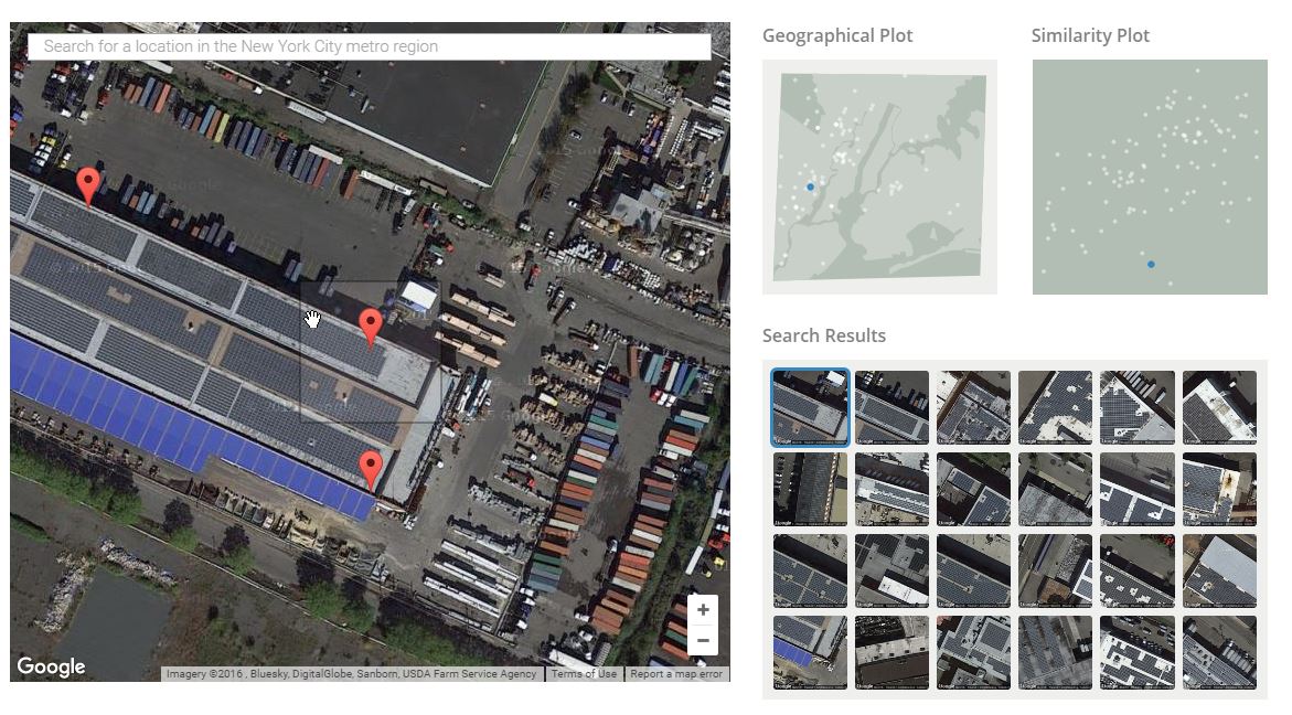
Currently in an early “Alpha” stage, TerraPattern provides the technology for users to locate an area of interest on an image, for example over a building with solar panel rooftop. The service then seeks out areas with a similar image footprint. The search results are displayed in a pleasant result box along with a map that shows where the similar places are found geographically compared to the selected point/place on the map.

The service provides image recognition for several cities including: New York, San Francisco, Pittsburgh, and Detroit. Give it a go at http://www.terrapattern.com

Thanks to Paul B for the cool Tip!


Filed Under: Around the Web, Earth Imaging - Remote Sensing, Software, SPOTLIGHTS, Tips, Top Press Tagged With: imaging, Open Source, TerraPattern

Editor’s Picks

Botswana Geoscience Portal goes live

HP Inc. Wraps Up Another Power-packed NAB Show

Mapping Water Use: Landsat and America’s Water Resources

Social Media is an Increasingly Important Part of Webmaps, Data Analysis, Analytics and Visualizations

See More Editor's Picks...

Recent Industry News

Top Benefits of AI Video Surveillance for Businesses and Public Spaces

June 5, 2026 By GISuser

How to Choose the Best Office Interior Designers in Delhi for End-to-End Projects

June 3, 2026 By GISuser

Why Bathroom Renovation Services Often Change More Than Just the Bathroom

May 20, 2026 By GISuser

The Drift Between Early Notes and Final Case Files in Abuse-Related Legal Support

April 29, 2026 By GISuser

Hot News

State of Data Science Report – AI and Open Source at Work

HERE and AWS Collaborate on New HERE AI Mapping Solutions

Virtual Surveyor Adds Productivity Tools to Mid-Level Smart Drone Surveying Software Plan

Categories

Copyright gletham Communications 2015 - 2026

Go to mobile version