GIS user technology news

News, Business, AI, Technology, IOS, Android, Google, Mobile, GIS, Crypto Currency, Economics

  • Advertising & Sponsored Posts
    • Advertising & Sponsored Posts
    • Submit Press
  • PRESS
    • Submit PR
    • Top Press
    • Business
    • Software
    • Hardware
    • UAV News
    • Mobile Technology
  • FEATURES
    • Around the Web
    • Social Media Features
    • EXPERTS & Guests
    • Tips
    • Infographics
  • Blog
  • Events
  • Shop
  • Tradepubs
  • CAREERS
You are here: Home / * PRESS / DATA / NGA provides unclassified geospatial intelligence for the Arctic

NGA provides unclassified geospatial intelligence for the Arctic

September 3, 2015 By GISuser

The National Geospatial-Intelligence Agency launched a public website Sept. 2 to provide unclassified information about the Arctic.

NGA provides unclassified geospatial intelligence for the Arctic

The public website supports efforts to strengthen international cooperation, better understand and manage resources responsibly, enhance quality of life in the Arctic and maintain valuable and vulnerable ecosystems.

The public site, accessible through www.nga.mil and located at nga.maps.arcgis.com, includes Digital Elevation Models that provide 3D representations of the Arctic’s surface. The models, derived from NGA-sponsored DigitalGlobe commercial imagery sources, support land management, sustainable development, safe recreation, scientific studies, and domain-specific challenges inherent to aviation, transportation and defense. The DEM is the standard against which landscape changes such as erosion will be measured.

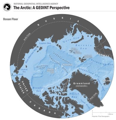
NGA’s Arctic website also includes NGA nautical charts, sailing directions, shape files and infographics. A large, downloadable Pan-Arctic map includes multiple layers that allow users to focus on specific issues and information. Layers include search and rescue zones, ice extents, economic exclusion zones, bathymetric data, navigational and meteorological warnings, and potential energy sources.

NGA is working with the National Science Foundation and the White House Office of Science and Technology Policy to support the Arctic initiative by producing and contributing publicly-available products and data layers as they become available. NGA’s work also supports the Department of Defense Arctic Strategy and the safety of navigation in the air and on the seas.

NGA’s Arctic website shares the publicly-available online platform with its Nepal and Ebola relief sites, using Esri ArcGIS platform, hosted by Amazon Web Services.

For further information and media inquiries, contact Don Kerr, NGA chief media relations; Donald.B.Kerr@nga.mil, 703-600-9248 (mobile).

Filed Under: DATA, Environment, Government & OpenGov, Top Press

Editor’s Picks

10 Question GeoGeek Rapidfire – Ted Florence @Avenza

HERE Beta Will Challenge Your Google Maps Loyalty

Trimble Unity – Next Generation Suite of Software Applications for Water, Wastewater and Stormwater Utilities

DigitalGlobe Satellite Captures Dramatic Images of Alberta, Canada Oil Sands wildfire #fmmfire

See More Editor's Picks...

Recent Industry News

The Future of Competitive Gaming: Why DMA Technology is the Ultimate Performance Edge

June 24, 2026 By GISuser

Milwaukee M18FHZ-0 Hackzall Reciprocating Saw – For hardcore cutting in a compact size

June 19, 2026 By GISuser

How Enterprises Are Using AI to Automate 80% of Customer Interactions With Voice Agents

June 16, 2026 By GISuser

Why On Cloud Shoes Are Worth the Price in Mexico

June 16, 2026 By GISuser

Hot News

State of Data Science Report – AI and Open Source at Work

HERE and AWS Collaborate on New HERE AI Mapping Solutions

Virtual Surveyor Adds Productivity Tools to Mid-Level Smart Drone Surveying Software Plan

Categories

Copyright gletham Communications 2015 - 2026

Go to mobile version