
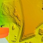
Montreal, Canada, August 6th, 2019 – SimActive Inc., a world-leading developer of photogrammetry software, announces that Correlator3D™ is being used in Japan for mapping projects acquired by the DJI Phantom 4 RTK. A full-scale validation was done in the mountains near Hiroshima with a unit flown by SimActive Japanese partner Mirukuru and customer Ace-1.
Training from SimActive – how to implement an optimal workflow with Correlator3D

The processing of large projects (e.g. 20,000 images @ 250 megapixels) presents huge challenges to the mapping industry. SimActive’s training session ‘Streamlining large photogrammetric projects with Correlator3D’ will discuss how to implement an optimal workflow with Correlator3D, using the proper level of automation and hardware resources.
SimActive Launches New Drone Processing Service

Montreal, Canada, June 25th, 2019 – SimActive Inc., a world-leading developer of photogrammetry software, announces a new drone data processing service based on Correlator3D™. Clients can now upload full projects and have SimActive experts generate optimal results from their imagery, including DSMs, DTMs, 3D models and orthomosaics.
SimActive Software Enables Processing of Wingtra Drone Data
Montreal, Canada, May 14th, 2019 – SimActive Inc., a world-leading developer of photogrammetry software, announces that Correlator3D™ is being used for mapping projects acquired by Wingtra and its high-end vertical take-off and landing drone WingtraOne.
SimActive Software Used with eBee X for Shoreline Mapping

Montreal, Canada, April 9th, 2019 – SimActive Inc., a world-leading developer of photogrammetry software, announces that Correlator3D™ is being used for mapping projects in Brittany, France by Altimedias. An eBee X equipped with senseFly S.O.D.A. 3D camera is flown along the shoreline to produce high-resolution true orthomosaics and 3D models.
SimActive Releases Version 8.1 with Advanced Editing Tools
Montreal, Canada, March 12th, 2019 – SimActive Inc., a world-leading developer of photogrammetry software, announces the release of Correlator3D™ version 8.1 specifically addressing advanced needs from expert users. Added features include, among many improvements, new DEM editing capabilities.
SimActive Expands its Partner Network for Medium Format Camera Solutions

Montreal, Canada, February 12th, 2019 – SimActive Inc., a world-leading developer of photogrammetry software, announces the expansion of its network of resellers for medium format licenses. The new strategic alliances allow to address the growing market need for processing imagery from medium format sensors. Partners include firms such as LiDARUSA, who offers SimActive’s Correlator3D™ to […]
SimActive Releases Version 8.0 with 3D Modeling

Montreal, Canada, October 9th, 2018 – SimActive Inc., a world-leading developer of photogrammetry software, is proud to announce the release of version 8.0 with a new 3D modeling module for Correlator3DTM.
SimActive for Mining: Drones & Volume Calculation

Montreal, Canada, August 28th, 2018 – SimActive Inc., a world-leading developer of photogrammetry software, is proud to announce new features to improve volumetric calculation. Correlator3D™ now has integrated tools for users to generate precise statistics on mining activities.
SimActive Automates Drone Data Processing
Montreal, Canada, April 17th, 2018 – SimActive Inc., a world-leading developer of photogrammetry software, is proud to announce increased drone data automation in Correlator3D™.