
AgIntegrated’s customers will now have access to satellite imagery ranging from 15m to 45cm resolution, thanks to a new integration with SkyWatch EarthCache
India: researchers to predict flood damage using satellite data
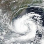
June 2020, Ref: PR 20-41 – As India recovers from the devastating effects of cyclones Amphan and Nisarga, world-renowned water researchers, HR Wallingford, will develop a method to predict damage from future flooding.