GIS user technology news

News, Business, AI, Technology, IOS, Android, Google, Mobile, GIS, Crypto Currency, Economics

  • Advertising & Sponsored Posts
    • Advertising & Sponsored Posts
    • Submit Press
  • PRESS
    • Submit PR
    • Top Press
    • Business
    • Software
    • Hardware
    • UAV News
    • Mobile Technology
  • FEATURES
    • Around the Web
    • Social Media Features
    • EXPERTS & Guests
    • Tips
    • Infographics
  • Blog
  • Events
  • Shop
  • Tradepubs
  • CAREERS
You are here: Home / Archives for RTK

Juniper® Systems Adds RTK Precision to Archer™ 4 GNSS Expansion Pod

May 14, 2025 By GISuser

An all-in-one RTK mapping solution  Logan, Utah, USA – May 14, 2025 – Juniper® Systems is pleased to announce that the GNSS Expansion Pod for the Archer™ 4 Rugged Handheld is now RTK capable. Juniper Systems is also launching a new application for the Archer 4 called Archer Connect. The Archer 4 with GNSS Expansion Pod […]

Filed Under: * PRESS Tagged With: adds, archer, expansion, GNSS, juniper, POD, precision, press, RTK, systems

Emlid upgrades its Reach RX RTK rover for seamless integration with GIS apps on iOS

August 9, 2024 By GISuser

Budapest, July 8th, 2024 Emlid, the European manufacturer of Reach GNSS receivers, announces an upgrade to its ultralight Reach RX Network RTK rover. The new generation of devices is updated with MFi (Made for iPhone/iPad) certification and is fully compatible with ArcGIS, QGIS, and other GIS apps for both iOS and Android. Flawless Reach RX […]

Filed Under: * PRESS Tagged With: (gis), apps, emlid, for, integration, ios, it’s, press, reach, rover, RTK, seamless, upgrades, with

Elevating Inspection Accuracy: The Impact of RTK

May 13, 2024 By GISuser

With the constant evolution of technology, the field of inspections has witnessed remarkable advancements in recent years. One such technology that has revolutionized inspection accuracy is Real-Time Kinematic Global Navigation Satellite System (RTK GNSS). This article delves into the advantages, implementation, challenges, future trends, and the importance of choosing the right RTK GNSS provider in […]

Filed Under: Around the Web Tagged With: accuracy, around, elevating, impact, inspection, RTK, the, web

Propeller Aero and DJI Expand Partnership with PPK Support for M300 RTK Drone to Provide Unparalleled Survey Data Accuracy

September 7, 2021 By GISuser

DJI’s M300 drone and Zenmuse P1 sensor will now be supported by Propeller’s powerful drone data collection processing software, allowing hundreds of acres to be surveyed in a fraction of the time, accurate within a fraction of an inch

Filed Under: Business, UAV/UAS Tagged With: RTK, UAV

SBG Systems renews its popular line of miniature inertial sensors

June 22, 2020 By GISuser

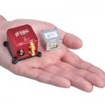
Ellipse Series 3rd Generation: SBG Systems renews its popular line of miniature inertial sensors with high-end functionalities and dual frequency RTK

Filed Under: Hardware Tagged With: GNSS, RTK

Emlid Reach RS2 – Multi-band RTK GNSS receiver

March 26, 2019 By GISuser

Emlid Reach RS2 - Multi-band RTK GNSS receiver

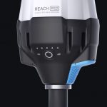
Emlid Reach RS2 – Multi-band RTK GNSS receiver for $1899 – Emlid, the creators of Reach, centimeter-accurate RTK GNSS receiver, launched pre-orders for their multi-band GNSS receiver Reach RS2. The new receiver features built-in LoRa radio, 3.5G modem and a survey app for iOS and Android.

Filed Under: Hardware, Infographics Tagged With: GNSS Receiver, RTK

Hemisphere GNSS Releases New Innovative, World-Class GNSS RTK Engine

May 7, 2015 By GISuser

Athena™ Engine to Provide Future-Proof Foundation for Current and Future Product Lines

Filed Under: Business, GPS Tagged With: Hemisphere GNSS, RTK

Recent Industry News

The Drift Between Early Notes and Final Case Files in Abuse-Related Legal Support

April 29, 2026 By GISuser

Aerial Surveys Int’l and Global Marketing Insights to Present GEOINT 2026 Workshop on Multi-Domain Geospatial Fusion for Automated Infrastructure Monitoring

April 24, 2026 By GISuser

Why Timing Matters More Than You Think With Spray Seal (And Why People Often Get It Slightly Wrong)

April 22, 2026 By GISuser

The Quiet Planning Stage Most People Don’t See When Building a Pool in Brisbane

April 22, 2026 By GISuser

Hot News

State of Data Science Report – AI and Open Source at Work

HERE and AWS Collaborate on New HERE AI Mapping Solutions

Virtual Surveyor Adds Productivity Tools to Mid-Level Smart Drone Surveying Software Plan

Categories

Copyright gletham Communications 2015 - 2026

Go to mobile version