
The Texas Department of Transportation (TxDOT) has selected Fugro to provide site characterisation services in support of a USD 250 million highway improvement project near Dallas. Fugro is delivering their services under a 5-year (2019-2024) indefinite delivery indefinite quantity contract (IDIQ) for TxDOT and this is the first work authorisation issued under the IDIQ. Fugro’s final deliverables for this important infrastructure project are scheduled for March 2021.
Fugro’s new 5-year geotechnical engineering services contract for Louisiana DOTD supports roadway and bridge design

Fugro has been awarded a 5-year indefinite delivery indefinite quantity (IDIQ) contract by the Louisiana Department of Transportation and Development (DOTD) to provide statewide geotechnical engineering services. The contract, which runs from July 2020 to July 2025, was issued by DOTD’s Engineering Division to support roadway and bridge design projects in Louisiana.
Fugro’s ROV survey and monitoring services help install world’s longest subsea interconnector
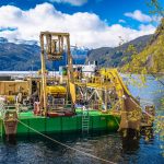
Fugro has completed a contract for Nexans to provide remotely operated vehicle (ROV) survey and monitoring support services to lay the North Sea Link cable through a mountain and along a lakebed in Norway.
Fugro ramps up site characterisation programme for Atlantic Shores Offshore Wind in US
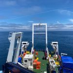
Fugro has mobilised two additional vessels off the coast of New Jersey to support their ongoing site characterisation work for Atlantic Shores Offshore Wind, a joint venture between Shell New Energies US LLC (Shell) and EDF Renewables North America. Operating in the Atlantic Shores lease area since May, Fugro now has three vessels on site with a fourth to be added later this month.
Fugro combines UXO and geotechnical surveys for Wismar port biomass power plant

Fugro has successfully completed a combined 2-month unexploded ordnance (UXO) and geotechnical survey for a new biomass power plant at the port of Wismar in northern Germany.
Fugro partners with Australian Space Agency on new robotics control complex

The Australian government’s newly formed Australian Space Agency (ASA) has partnered with Fugro to design, build and operate the Australian Space Automation, Artificial Intelligence and Robotics Control Complex (SpAARC) in Western Australia (WA).
Fugro wins Innovate UK ‘First of a Kind’ funding to support rail industry innovation

Fugro is one of the successful companies to win innovation funding from Innovate UK’s ‘First of a Kind’ (FOAK2020) competition under the theme of optimised and cost-effective rail maintenance. The FOAK2020 award will fund 9 months of development of Fugro’s Innotamp project in collaboration with Network Rail. A world-first for track maintenance, the funded project will demonstrate how track alignments generated using Geo-data from Fugro’s Raildata Solution can be directly uploaded to a tamper’s computer to optimise tamping of […]
FUGRO ANNOUNCES PARTNERSHIP WITH SHELL OCEAN DISCOVERY XPRIZE
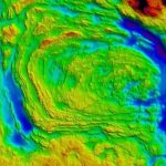
Fugro today announced a partnership with the Shell Ocean Discovery XPRIZE to support first round testing of the global, three-year competition, which incentivises development of rapid, unmanned and high resolution ocean mappingtechnologies.
FUGRO’S G4 SATELLITE CORRECTION SERVICE OPTIMISES LATEST GALILEO LAUNCH
As a result of a significant Fugro technology achievement, users of its G4 satellite correction service will be among the first in the world to benefit from Galileo’s much anticipated ‘initial services’ launch.
SURVEYING AND MAPPING CONTRACT EXTENDS FUGRO’S 30-YEAR PARTNERSHIP WITH ST. LOUIS CORPS OF ENGINEERS
Fugro has been awarded a photogrammetric and LIDAR surveying and mapping contract by the US Army Corps of Engineers, St. Louis District, Missouri. This five-year, indefinite delivery indefinite quantity (IDIQ) contract has a ceiling value of US$12.5 million and marks Fugro’s third consecutive mapping contract with the Corps, making this a partnership that has spanned […]