
Rhode Island Signs Participating Addendum with DroneUp Providing Public Sector Agencies Access to Drone Services
MEASURE Announces New Product Features to Support Autonomous Drone Operations for Enterprise Customers
WASHINGTON and AUSTIN, Texas, March 31, 2021 — MEASURE, a leading aerial intelligence company, announced today its latest product release on the industry-leading Ground Control platform, including support for the DJI Matrice 300 (M300), the addition of Pix4D Fields to its cloud data processing, Coordinate Reference System optionality, and expansion of flight planning tools to include CSV import and coverage […]
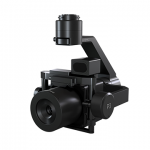
Phase One Announces P3 Drone Payload for Asset Inspection
Productive and Versatile
Hepta Airborne’s self-service platform speeds up drone image analysis

Following years of internal use and improved performance in analyzing electricity grids across the EU, the Estonian-founded tech company, Hepta Airborne is releasing a freemium version of its AI-driven software, uBird, to the drone operator community.
Esri’s Site Scan for ArcGIS Introduces New Capabilities for US Drone Pilots

Integration with Airspace Link Provides UAS Pilots with Automated Approval to Fly in Controlled Airspace
Estonian Railways conducts a pilot project with Hepta Airborne to digitize physical railway assets using drones and AI-driven analysis

Estonian Railways and technology company Hepta Airborne conducted a successful pilot project, which applied innovative inspection methodologies to map railway infrastructure faster and without the need to stop railway traffic, while also increasing the safety of railway employees. Conducting railway utility inspections with traditional methods is hazardous and time-consuming work that must be streamlined in […]
Commercial UAV Expo Americas Advisory Board Announced
Advisory Board Set for Commercial UAV Expo Americas September 7-9, 2021 in Las Vegas 23 experts have been tapped to help craft critical programming for commercial UAS end-users
Global Commercial Drone Market Expected to Exceed $8.5 Billion By 2027
PALM BEACH, Fla., Feb. 24, 2021 — 2021 will be a breakout year for the drone industry. For years, the drone market was in a nascent phase and had yet to break into the mainstream.
Down to Earth – Drone Lidar Surveying Reality Series Returns

Down to Earth – Drone Lidar Surveying Reality Series Returns – “Down to Earth” is a reality series that shows how real surveyors collect data and turn it into real deliverables, despite challenging conditions, rugged terrain and lurking danger.
Florida Signs Participating Addendum with DroneUp Providing Public Sector Agencies Access to Drone Services
VIRGINIA BEACH, Va., Feb. 9, 2021 /PRNewswire/ — DroneUp, LLC and the State of Florida have signed a Participating Addendum for the NASPO ValuePoint contract for Unmanned Aerial Vehicle services established as the Contract Source Code 25132100-NAPSO-ACS. This begins the offering for the purchase of complete drone solutions to all state agencies, commissions, political subdivisions, institutions, and local public bodies […]