
Most of your image analysis tasks that required ENVI or Erdas Imagine software are now available online thanks to EOS Platform. This new game-changing cloud service launched by EOS Data Analytics provides GIS professionals with a one-stop solution for search, analysis, storing, and visualization of large amounts of geospatial data.
Imagery, earth imaging and remote sensing
CubeWerx releases ClearSkies online haze removal tool for aerial and satellite imagery
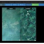
Gatineau, Canada, May 21, 2018 – CubeWerx today announced the general availability of its ClearSkies platform, a pay-as-you-go service for automatically removing light to medium haze from high-resolution remote sensing imagery.
Galileo (GNSS) the precise Global Satellite Navigation System – a Launchpad for New Applications
Approximately 75 million Galileo-ready smart phones were sold in 2017. Currently, 95 percent of chipsets on the market are compatible with Galileo, the European Global Satellite Navigation System (GNSS).
Copernicus App Lab’s Earth Observation Data Tools Ready for Developers
Unprecedented linked open data tools are now ready for testing in the Copernicus App Lab online beta phase. Participants can use the tools for free to get easy access to Earth observation (EO) data from the European Copernicus programme and link it with other data sources. The Copernicus App Lab’s overall objective is to support […]
SpaceDataHighway starts full Copernicus service
Munich, 19 March 2018 – The Airbus-operated SpaceDataHighway has begun regularly relaying data from the Sentinel-2A satellite, after the successful end of the commissioning period. This marks the start of the SpaceDataHighway service using all four Copernicus Sentinel satellites and the beginning of a new era for space-based imagery users.
High-Resolution Satellite Images of the March for Our Lives
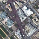
Maxar News Bureau released high-resolution satellite images of the March for Our Lives rally in Washington, D.C. The images were captured by DigitalGlobe’s WorldView-2 satellite at 11:59 a.m. EDT
exactEarth High Performance AIS Payload Launched on Paz Radar Satellite
Completes exactEarth’s First Generation Satellite AIS Constellation
Maxar Technologies’ DigitalGlobe Expands Agreements with Two Major Commercial Technology Customers
Maxar Technologies’ DigitalGlobe Expands Agreements with Two Major Commercial Technology Customers, Extending Its Leadership Position in High-Resolution Satellite Imagery
Summit on Earth Observation Business
Summit on Earth Observation Business (part of the World Satellite Business Week)
DigitalGlobe Imagery: Philadelphia Eagles Super Bowl Parade

Today DigitalGlobe’s WorldView-3 satellite caught some great shots of the Super Bowl parade in Philadelphia. Taken at 11:13 a.m. EST this morning, the images show the main crowd gathered at the Philadelphia Museum of Art, and the motorcade players and coaching staff can be seen turning onto Broad Street.