

Each year, we witness new trends in technology. Cell phones were used for only communication purposes now help us through navigation, entertain us, and help us explore the internet. How amazing is that? Continue reading “Why is TheWiSpy The Best Android Spy App? Let’s Discuss”
Category: Mobile GIS, GPS and Location Services (LBS)
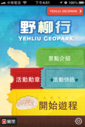
GIS Applications Feature – Yehliu Tour System (Android & iOS)
|
||||
| Goals | ||||
|
Yehliu Geopark is planning to offer tourists with the new version of Yehliu Tour System for Android and iOS. Moreover, to increase the interaction and amusement on using this system, Augmented Reality (AR) has been added up, allowing tourists intuitively get the scenic spot positions. Also, there are games in the tour system, having the system more interesting. As to park information, Hot News is added to the system for tourists to review the periodical park event information. |
||||
| Solutions | ||||
|
With SuperGIS Mobile Tour, SuperGIS Mobile Engine for Android and SuperGIS Mobile Engine for iOS as the developing core, GIS and GPS integrated, Yehliu Tour System is developed to be a tour system that has GPS function, scenic spot guidance, Augmented Reality (AR) and basic GIS functions. Tourists are able to download the tour system from Google Play or App Store to install on their smart devices. After entering the park, the tourists can start the multi-media tour system after selecting the built-in tour routes or create their own tour route by adding scenic spots to visit. |
||||
|
||||
| Results | ||||
|
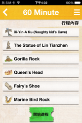
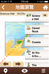
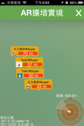
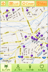
Yehliu Tour System includes five major functions:Start , Scenery Introduction, Event Stamp, Hot News, and System Settings. As the system turns on, users can select and browse. I. Start On the scenery list where you are able to arrange the route, tapping a scenery name can show the scenery info, including text description, pictures, audio service and AR. As the route is selected, users can start the tour by tapping Start and enter the map to start the tour service. The main functions include map browse, audio service and the scenery introduction in AR.
|
||||
| 1. Map Browsing ‧Browse Map: manipulating with fingers and gestures can zoom in/zoom out or pan the map; tapping the scenery icon can review the detailed introduction; by tapping the buttons, users can set the previous/next scenery as the target destination. ‧Pan to GPS Position: Pan the map to the current GPS position, showing a man-shaped icon as GPS position and fan-shaped icon as the heading direction on the map. ‧Routes: all sceneries on the route will be listed and the next target scenery will be marked with an arrow. |
||||
|
2. Audio Service 3. Augmented Reality Additionally, the radar chart of Mission Scenery is shown below the reality view. The mission sceneries can be found by the labeled locations and directions. Matching the park’s seasonal events, the new function “Mission Scenery” offers some small games. Users can tap “Mission Scenery” icon, enter the simulated screen and shake the smart device up and down just like the gesture of catching something to have the device sensed and get the metals as rewards. |
||||
|
||||
|
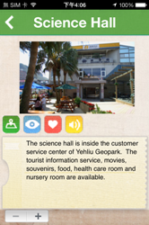
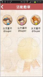
II. Scenery Introduction Tap the scenery name to show the detail information, including scenery description, picture, audio service, map browse and AR. III. Event Stamp IV. Hot News |
||||
|
||||
|
Effects: Users can download Yehliu Tour System straightly and install on Android and iOS smart devices. This is a new way to recognize and perceive the natural sceneries and features of Yehliu. In this way the Yehliu Geopark can save the cost on printing paper flyers and provide another way to interact with tourists and bring them more fun. |


What businesses can learn from the booming wearable technology industry
In 2012, 30 million wearable, wireless monitoring devices were sold in the U.S. That figure spiked 37% from the number sold in 2011. In the “2013 Internet Trends” report released by KPCB a few months ago, Mary Meeker and Liang Wu noted an unusual pattern in computing cycles: the first cycle was Smartphones, followed 10 years later by Tablets as the second cycle. However, Wearables /Drivable devices, or the third cycle, represent an industry that is growing faster than the typical 10-year cycle.
Wearable technology includes devices that measure your physical activity, your blood oxygen levels and even your sleep, and this rapidly growing industry is showing no signs of slowing down. Research predicts that sales will rise to 160 million devices by 2017, and IMS Research puts the wearables market at $6B by 2016.
So what next?
With wearable technology providing us with insights that can be used to change our behavior for the better, this has contributed to a major shift in the healthcare industry. We are already seeing insurers start to encourage consumers to use these devices not only to boost fitness, but also to reduce their health-care costs.
According to a Forrester Research report we can expect the wearable device market to be an important battleground for the big platform makers, including Apple, Google, Microsoft, Amazon and Facebook.
Mobile Feature – Using An iOS Mobile GIS App to Provide Reliable Tour Guide: Yilan Travel Guide App
| Scenario | ||||||||
|
||||||||
| Goals | ||||||||
|
In consideration of ubiquity of smart phone, this project plans to develop an application which is applicable on iOS system. Besides, this application is designed to equip with the functions including tourist destination introduction, map display and itinerary plan. People who want to have a trip in Yilan can download this application and apply it on smart phones. Thus, this application is required to equip with simple manipulation interface, plentiful introduction of tourist destinations, tourism map display function and itinerary plan function. Tourists are able to view the map and query special tourism with famous tourist destinations, food, accommodation, natural experiences and so on in Yilan by downloading and applying this App. For this reason, through this App, the local culture and natural feature of Yilan can also be promoted. |
||||||||
| Solutions | ||||||||
|
In order to promote the features of local tourist attraction and important local customs, Department of Applied Economics & Management of National Yilan University and Yilan Leisure Farming Development Association cooperate to develop “Yilan Travel Guide App” which is applicable on iOS operation system. Integrating with Google Map, Yilan Travel Guide App can display location of the tourist attractions and enables users to plan itinerary routes. Tourists who would like to have a trip to Yilan can apply this application on their smart phones or tablet PC to search tourism information of Yilan over the Internet. Additionally, tourists can spend their holidays in Yilan easily by obtaining the information of nearby tourist attractions and planning the routes with this application. |
||||||||
| Results | ||||||||
|
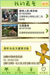
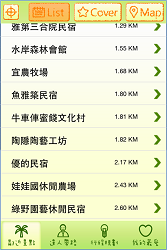
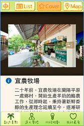
Yilan Travel Guide App is the application applicable on iOS system. The four main themes of this application include “Nearby Tourist Attractions”, “Specialists Lead the Way”, “Itinerary Plan” and “My Favorite.” 1. Nearby Tourist Attractions: By utilizing this function, users are able to query the nearby tourist attractions by locating manually or automatically. The query result shows in a list or with a picture. In addition, users can choose to mark the tourist attractions on the map. |
||||||||
|
||||||||
|
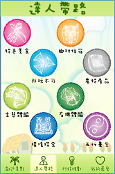
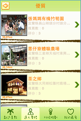
2. Specialists Lead the Way: In this theme, you can tap on the topic that you are interested in, including “Typical Food”, “Accommodation in the Countryside”, “Must Play”, “Specialty Agricultural Products”, “Natural Experience”, “Organic Experience”, “Nature Exploration” and “Five Elements and Health.” Under these topics, the contents are divided into three classes including superior class, recommendation class and popular class. Users can refer to different contents according to the classes which show stores in a list and display the reference distance between the tourist attraction and users’ location. |
||||||||
|
||||||||
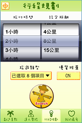
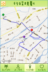
| 3. Itinerary Plan: This theme enables users to set “Travel Time” and “Specify Distance” as condition to search and plan itinerary instantly and flexibly according to trip types and superior recommendation. Please refer to the following pictures: | ||||||||
 |
 |
 |
||||||
| 4. My Favorite: With “My Favorite”, users are able to save information of tourist attractions and the stores they are interested in for search or viewing next time. | ||||||||
|
Effects: Integrating with information of local tourist attractions and map display, “Yilan Travel Guide App” allows users to use various functions like querying tourist attractions around, searching recommended stores and etc directly and the app does promote features of local customs effectively. Now, this App displays tourist attractions by overlaying base map on Google Map. In days to come, the project plans to adopt SuperGIS Server to integrate map, tourist attractions and information of store location of Yilan, and to publish the relevant information as map services. Therefore, users can query tourism information instantly through browsers, and system administrators are able to update and edit information of tourist attractions and stores on browsers, too. |
||||||||


Juniper Systems Webinar Recap – Collect Professional Grade GIS Data, fast, easy, and cost effective!
Want to Collect Professional Grade GIS Data without Complicated Mapping Software? Well if so, Juniper Systems answered that question recently via a live webcast. The Topic, Juniper Aspect
Lakeport, Calif., replaces manual weed control with fully automated Trimble WeedSeeker system
Cut Weed Control Cost by 80% California City Saves $24,000 and 600 Hours in Staff Time Annually with Automated Weed Control
Mobile GIS Tip – Integrity GIS on iOS from Midland GIS Solutions @Midlandgis
Here’s a fine introductory video to a cool app, Integrity GIS for iOS (iPhone or iPad). What I really like about what the team has done here is they’ve provided users with a free, trial download app in the iTunes store so you can test drive it for yourself… nice! Please note, the app requires iOS 6.
Features
- GPS Location Services
- GPS Buffer Identify – Easily view nearby features and their attributes.
- Measure by Length or Area and adjust units on the fly.
- Area Identify Features – Select an area on the map and see all the features located within.
- Full Search Engine – Select which map layers you want to include in your results.
- Smart Search Results
- Media Viewing and Streaming – Great for viewing pictures or streaming video linked to specific features.
- Map Layers – Adjust the visibility of map layers and the app remembers your settings every time you come back.
- Map Legend – Visual reference to learn the symbols of map features.
For more information about the app head over to the Midland GIS Solutions webpage and see here
Follow Midland GIS Solutions on Twitter @midlandgis

10 Must Have Documents For Getting Started With iOS 6 Location Aware Apps and Mapping Apps
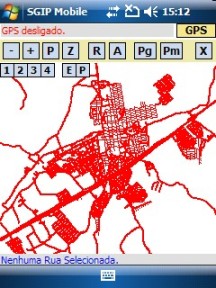
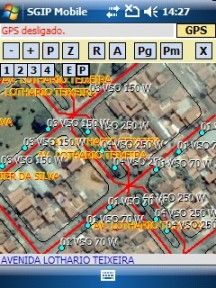
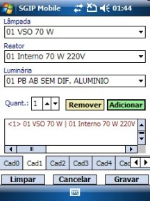
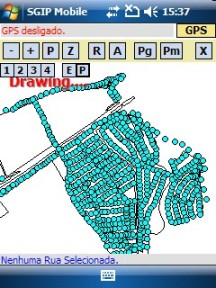
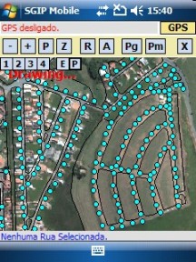
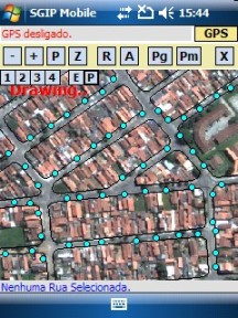
GIS Application Story – Engeluz SGIP-Mobile
|
||||||||||||||||||||||||||
| Goals | ||||||||||||||||||||||||||
|
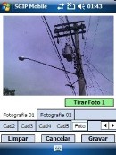
In the Public Lighting Management Plan, Engeluz would need to offer the methods to monitor, maintain, supervise, and plan the Public Lighting System. Thus, a mobile GIS system would be required to help the local government to know the locations of the public lights, the energy consumption, and plan maintaining, and optimize the use of materials and resources. Therefore, the mobile GIS system should not only contain the basic GIS manipulation functions but include camera function that would be quite helpful for surveyors to record the relevant data. |
 |
|||||||||||||||||||||||||
| Solutions | ||||||||||||||||||||||||||
|
To establish a mobile GIS system to meet the requirements, Engeluz adopts SuperGIS Mobile Engine 3 to develop Engeluz SGIP-Mobile that enables government staff to collect the field data through the mobile devices, like PDA. SuperGIS Mobile Engine 3 is a mobile GIS SDK. The high flexible development structure, nearly 100 out-of-the-box toolbar buttons, and development sample instruction assist developers in developing intuitive mobile GIS applications. In addition, SuperGIS Mobile Engine 3 allows developers to deploy applications on a large scale; thus, it is useful and economical for developers to deploy the applications to a large number of mobile devices.
|
||||||||||||||||||||||||||
|
||||||||||||||||||||||||||
| Results | ||||||||||||||||||||||||||
|
||||||||||||||||||||||||||


Mobile Marine Debris Tracker App – Help NOAA Track Marine Debris from the Japanese Tsunami
Recall we recently featured an update from NOAA about the Japan Tsunamis debris field that is headed towards the shoreline of North America. NOAA has made available many resources, however, there really isn’t much effort (yet) to deploy a popular mobile app to help in monitoring debris that has been found. There is, however, one app available for the Android mobile OS – "Marine Debris Tracker" – see Android Market
Some details of the app:
The first time you use Marine Debris Tracker, you will need to choose a username and password. This will allow you to view and download your data from the website.
The public data available for viewing and download on the website is anonymous, and you need your username and password to see and download your data as a separate file
Once you have registered once, your username and password is all you need to submit all your tracked data each tracking session
For more information about the app See the homepage at http://www.marinedebris.engr.uga.edu/ . Here you can get complete details on how to load the app, how to use it, see recent debris finds, browse top users, see press updates and more.
For help on getting started with the app see HERE


Source: sea-mdi.engr.uga.edu via Glenn on Pinterest
About the app
The Mobile App Marine Debris Tracker is a joint partnership of the NOAA Marine Debris Division and the Southeast Atlantic Marine Debris Initiative (SEA-MDI), located within the Faculty of Engineering at the University of Georgia. A primary goal of SEA-MDI is to use innovative technologies and unique expertise to add culturally relevant outreach tools and information to the current NOAA Marine Debris Division. Marine Debris Tracker is the first product of this initiative. It is our hope that it will spread awareness of marine debris, as well as serve as an easy to use and simple tool for marine debris data collection.
See Also:
NOAA Tracking Marine Debris from the Japanese Tsunami – Debris from the tsunami that devastated Japan in March could reach the United States as early as this winter, according to predictions by NOAA scientists. However, they warn there is still a large amount of uncertainty over exactly what is still floating, where it’s located, where it will go, and when it will arrive.
Mapping the Pacific Garbage Patch and Ocean Currents Moving Plastics and Debris