GIS user technology news

News, Business, AI, Technology, IOS, Android, Google, Mobile, GIS, Crypto Currency, Economics

  • Advertising & Sponsored Posts
    • Advertising & Sponsored Posts
    • Submit Press
  • PRESS
    • Submit PR
    • Top Press
    • Business
    • Software
    • Hardware
    • UAV News
    • Mobile Technology
  • FEATURES
    • Around the Web
    • Social Media Features
    • EXPERTS & Guests
    • Tips
    • Infographics
  • Blog
  • Events
  • Shop
  • Tradepubs
  • CAREERS
You are here: Home / environment / How people use social media in emergencies

How people use social media in emergencies

September 1, 2011 By Editor

David Murphy of PC Magazine recently published an article that looked at the role of social media in emergency response – this article came out post hurricane Irene.  The piece looks at information based on a report out of the Red Cross that looks at how people view social media networks and the role they play in emergency response and crisis situations.  According to the Red cross, the org has been told by the public that they want communications by facebook and they seek comfort in updates that come via Twitter.

This from the article… “The Red Cross surveyed around 2,050 individuals in a nearly equal mix of phone and online surveys, finding that people consider the Internet to be the third most popular method for gathering emergency information beyond television and radio announcements. And people also want their own requests for information and assistance processed in a timely manner: 39 percent of online respondents and 35 percent of telephone respondents would expect help within an hour’s time if they asked for it via a social media platform.”

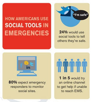
The author has put together an interesting infographic (a portion seen below)  about how people use social media in emergencies

See details here on PCMag

Filed Under: environment, hurricane, Social Media

Editor’s Picks

jack dangermond

First Look – Los Angeles Opens the GeoHub – #OpenData for Citizens and Developers

A Decade of Change in America’s Arctic: New Land Cover Data Released for Alaska

Maps attributed to the 13th-century traveler sketch what looks like the coast of Alaska

47th Annual Magnet States Report — Where Did America Move in 2014?

See More Editor's Picks...

About Editor

Glenn is a geographer and a GIS professional with over 20 years experience in the industry. He's the co-founder of GISuser and several other technology web publications.

Recent Industry News

Why Adults Are Trimming Their Routines for Travel and Busy Weeks

June 10, 2026 By GISuser

Top Benefits of AI Video Surveillance for Businesses and Public Spaces

June 5, 2026 By GISuser

How to Choose the Best Office Interior Designers in Delhi for End-to-End Projects

June 3, 2026 By GISuser

Why Bathroom Renovation Services Often Change More Than Just the Bathroom

May 20, 2026 By GISuser

Hot News

State of Data Science Report – AI and Open Source at Work

HERE and AWS Collaborate on New HERE AI Mapping Solutions

Virtual Surveyor Adds Productivity Tools to Mid-Level Smart Drone Surveying Software Plan

Categories

Copyright gletham Communications 2015 - 2026

Go to mobile version