GIS user technology news

News, Business, AI, Technology, IOS, Android, Google, Mobile, GIS, Crypto Currency, Economics

  • Advertising & Sponsored Posts
    • Advertising & Sponsored Posts
    • Submit Press
  • PRESS
    • Submit PR
    • Top Press
    • Business
    • Software
    • Hardware
    • UAV News
    • Mobile Technology
  • FEATURES
    • Around the Web
    • Social Media Features
    • EXPERTS & Guests
    • Tips
    • Infographics
  • Blog
  • Events
  • Shop
  • Tradepubs
  • CAREERS
You are here: Home / * PRESS / Earth Imaging - Remote Sensing / @Maxar Satellite Imagery: Falcon 9 Rocket with Cargo Dragon Capsule, Kennedy Space Center

@Maxar Satellite Imagery: Falcon 9 Rocket with Cargo Dragon Capsule, Kennedy Space Center

June 3, 2021 By Editor

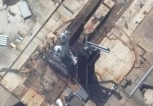
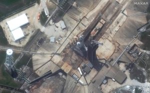
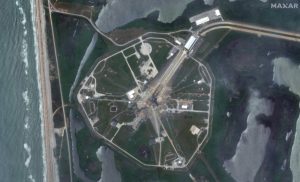
Maxar collected new satellite images yesterday and today of the SpaceX Falcon 9 rocket with its Cargo Dragon capsule at SLC 39A in the Kennedy Space Center. Today’s WorldView-3 high resolution view shows the rocket at the launch pad approximately 70 minutes before its successful launch today (3 June).

Maxar Satellite Imagery: Falcon 9 Rocket

Satellite image ©2021 Maxar Technologies

Filed Under: Earth Imaging - Remote Sensing, Top Press Tagged With: maxar

Editor’s Picks

Unique Hand Drawn Map of London – Ten Years in the Making

Reading – Reduce Your Open Source Security Risk

Infographic – What’s New in iOS 8?

Blue Marble Announces Advanced LiDAR Option for the Global Mapper SDK

See More Editor's Picks...

About Editor

Glenn is a geographer and a GIS professional with over 20 years experience in the industry. He's the co-founder of GISuser and several other technology web publications.

Recent Industry News

Aerial Surveys Int’l and Global Marketing Insights to Present GEOINT 2026 Workshop on Multi-Domain Geospatial Fusion for Automated Infrastructure Monitoring

April 24, 2026 By GISuser

Why Timing Matters More Than You Think With Spray Seal (And Why People Often Get It Slightly Wrong)

April 22, 2026 By GISuser

The Quiet Planning Stage Most People Don’t See When Building a Pool in Brisbane

April 22, 2026 By GISuser

Best Equipment Labels for Industrial Use: Ranked Systems That Survive Real-World Conditions

April 17, 2026 By GISuser

Hot News

State of Data Science Report – AI and Open Source at Work

HERE and AWS Collaborate on New HERE AI Mapping Solutions

Virtual Surveyor Adds Productivity Tools to Mid-Level Smart Drone Surveying Software Plan

Categories

Copyright gletham Communications 2015 - 2026

Go to mobile version