GIS user technology news

News, Business, AI, Technology, IOS, Android, Google, Mobile, GIS, Crypto Currency, Economics

  • Advertising & Sponsored Posts
    • Advertising & Sponsored Posts
    • Submit Press
  • PRESS
    • Submit PR
    • Top Press
    • Business
    • Software
    • Hardware
    • UAV News
    • Mobile Technology
  • FEATURES
    • Around the Web
    • Social Media Features
    • EXPERTS & Guests
    • Tips
    • Infographics
  • Blog
  • Events
  • Shop
  • Tradepubs
  • CAREERS
You are here: Home / * PRESS / Business / Satellite Imagery: Before/After Imagery of Hurricane Laura Landfall in Louisiana

Satellite Imagery: Before/After Imagery of Hurricane Laura Landfall in Louisiana

August 31, 2020 By GISuser

Maxar collected a set of new imagery today (August 27th) of the aftermath of Hurricane Laura as it rapidly moved through Cameron and Lake Charles, Louisiana. Significant damage to homes, buildings and infrastructure can be seen across the region.


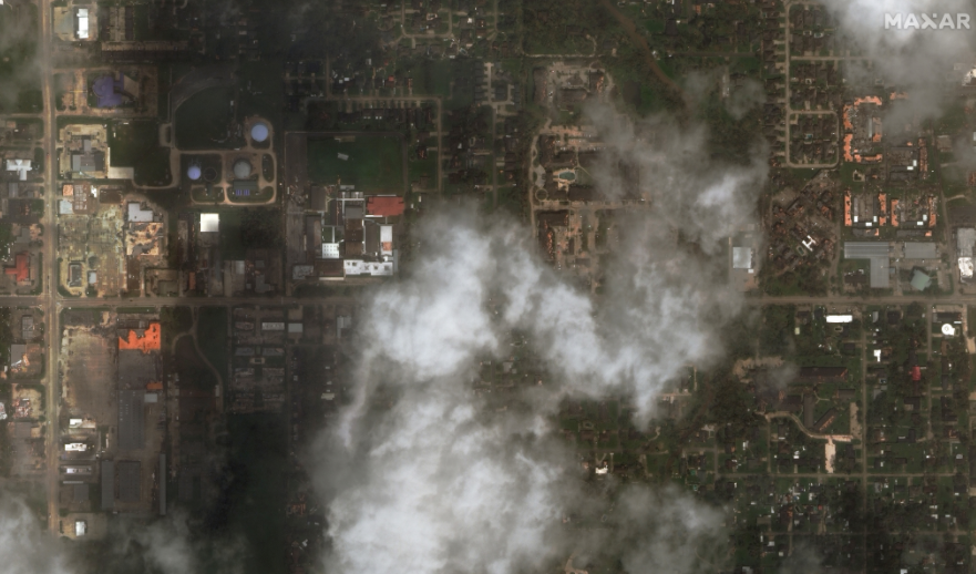
Satellite image ©2020 Maxar Technologies.

Filed Under: Business, Earth Imaging - Remote Sensing Tagged With: maxar

Editor’s Picks

Top 10 Online Local Search and Map Services Where your Business HAS to be listed!

Trimble Unity – Next Generation Suite of Software Applications for Water, Wastewater and Stormwater Utilities

Salary Guide, Tips for Fastest Growing Industries & Top Technology Positions in Demand

Esri Launches New Site to Find Open Data

See More Editor's Picks...

Recent Industry News

The Future of Competitive Gaming: Why DMA Technology is the Ultimate Performance Edge

June 24, 2026 By GISuser

Milwaukee M18FHZ-0 Hackzall Reciprocating Saw – For hardcore cutting in a compact size

June 19, 2026 By GISuser

How Enterprises Are Using AI to Automate 80% of Customer Interactions With Voice Agents

June 16, 2026 By GISuser

Why On Cloud Shoes Are Worth the Price in Mexico

June 16, 2026 By GISuser

Hot News

State of Data Science Report – AI and Open Source at Work

HERE and AWS Collaborate on New HERE AI Mapping Solutions

Virtual Surveyor Adds Productivity Tools to Mid-Level Smart Drone Surveying Software Plan

Categories

Copyright gletham Communications 2015 - 2026

Go to mobile version