GIS user technology news

News, Business, AI, Technology, IOS, Android, Google, Mobile, GIS, Crypto Currency, Economics

  • Advertising & Sponsored Posts
    • Advertising & Sponsored Posts
    • Submit Press
  • PRESS
    • Submit PR
    • Top Press
    • Business
    • Software
    • Hardware
    • UAV News
    • Mobile Technology
  • FEATURES
    • Around the Web
    • Social Media Features
    • EXPERTS & Guests
    • Tips
    • Infographics
  • Blog
  • Events
  • Shop
  • Tradepubs
  • CAREERS
You are here: Home / * PRESS / Business / OceanWise adds new software extension which drastically reduces segmentation time for marine images

OceanWise adds new software extension which drastically reduces segmentation time for marine images

July 3, 2018 By GISuser

OceanWise has added a dynamic software Extension to Maritime Toolbar for Esri ArcMap, which powerfully and easily helps the user to manipulate maritime data.

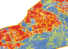
This latest extension ‘Object Based Image Analysis’ or ‘RSOBIA’ takes raster imagery and segments the data into geographic areas with similar statistical properties. It interprets the areas and boundaries seen in imagery (such as side scan sonar or multi-beam backscatter) and makes a polygonised map of the results.

This tool works with all types of imagery data and is quick and easy to use, drastically reducing the amount of time it takes to segment images and provides straight-forward, objective polygons which are statistically calculated.

With the emergence of GIS systems, data integration and fusion has allowed numerical and statistical interpretation techniques to be developed. This tool provides a quick and simple aid for classification within a GIS environment, thus supporting workflows.

RSOBIA is brought to market as a collaboration between OceanWise and their Licenced Partner Tim Le Bas, Senior Marine Habitat Scientist for the NOC.

To find out more about Tim Le Bas, the Object Based Image Analysis Extension ‘RSOBIA’ and Maritime Toolbar Extensions (Environmental Samples Management, Hydrographic Survey Management Extensions etc) please click here.
Filed Under: Business Tagged With: OceanWise

Editor’s Picks

How Safe is Google Wallet?

How Safe is Google Wallet?

US Army Corps of Engineers Selects SimActive for Drones

Boulder County Launches New Geospatial Open Data Platform

Real Earth™ Wins Microsoft Competition for 3D Mapping and Localization

See More Editor's Picks...

Recent Industry News

Bird Netting Installation in Dubai for Property Care 

July 11, 2026 By GISuser

How AI Helps Identify Crystals From Photos

July 10, 2026 By GISuser

The Future of Competitive Gaming: Why DMA Technology is the Ultimate Performance Edge

June 24, 2026 By GISuser

Milwaukee M18FHZ-0 Hackzall Reciprocating Saw – For hardcore cutting in a compact size

June 19, 2026 By GISuser

Hot News

State of Data Science Report – AI and Open Source at Work

HERE and AWS Collaborate on New HERE AI Mapping Solutions

Virtual Surveyor Adds Productivity Tools to Mid-Level Smart Drone Surveying Software Plan

Categories

Copyright gletham Communications 2015 - 2026

Go to mobile version
