GIS user technology news

News, Business, AI, Technology, IOS, Android, Google, Mobile, GIS, Crypto Currency, Economics

  • Advertising & Sponsored Posts
    • Advertising & Sponsored Posts
    • Submit Press
  • PRESS
    • Submit PR
    • Top Press
    • Business
    • Software
    • Hardware
    • UAV News
    • Mobile Technology
  • FEATURES
    • Around the Web
    • Social Media Features
    • EXPERTS & Guests
    • Tips
    • Infographics
  • Blog
  • Events
  • Shop
  • Tradepubs
  • CAREERS
You are here: Home / * PRESS / acquisitions and funding / Saildrone, Inc. raises $60 million in Series B funding

Saildrone, Inc. raises $60 million in Series B funding

May 16, 2018 By Editor

Saildrone, Inc. raises $60 million in Series B funding to scale its global fleet of wind-powered ocean sailing drones and accelerate its international expansion

ALAMEDA, Calif., May 15, 2018  — Saildrone, Inc., a provider of high-resolution ocean data collected via a fleet of unmanned surface vehicles, announced today that it has closed a $60 million round of Series B funding to scale up its global fleet of ocean drones to help monitor the state of the planet in real time. This round of funding was led by Horizons Ventures, with participation from existing investors which include Capricorn’s Technology Impact Fund, Lux Capital, Social Capital, and The Schmidt Family Foundation. This brings the total amount raised by the company since its commercial debut in 2016 to almost $90 million.
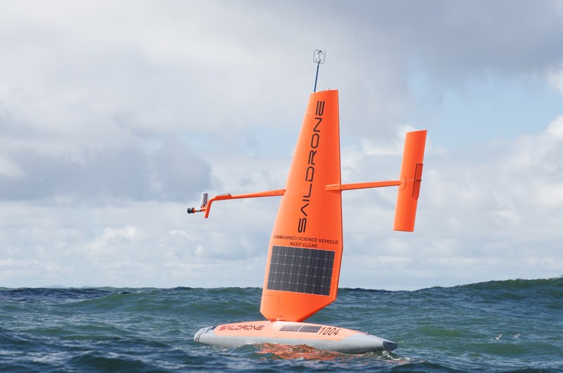
Saildrone Unmanned Surface Vehicle (USV) collecting ocean data in the Pacific (PRNewsfoto/Saildrone Inc.)

Saildrone envisions “a quantified planet,” and is building the next generation of ocean infrastructure to provide critical data for understanding the weather, managing fish populations, and enabling in-situ ocean science at an unprecedented scale and with unparalleled cost-efficiency. Since its inception, Saildrone has successfully partnered with US agencies such as NOAA and NASA to provide high-quality ocean observations. Now, as part of its expansion, the company recently announced a multi-year collaboration with Australia-based CSIRO and the opening of operations in the Southern Ocean from Hobart, Tasmania. Saildrone has also opened a 200,000 square foot advanced manufacturing facility in Alameda, CA. This expanded facility will enable Saildrone to accelerate its manufacturing and deployment of the 1,000 autonomous vehicles required to achieve global coverage of the world’s oceans at a six by six degree resolution.

“This is a major milestone for Saildrone, as deploying this new global infrastructure is a key enabler for our vision of ‘a quantified planet,'” says CEO Richard Jenkins. “The fleet we’re building will provide unprecedented high resolution in-situ data that will increase our understanding of the planet by orders of magnitude and thus benefit the vast majority of the world’s population.”

“Big data can help us understand changes in the state of the planet for generations to come,” said Bart Swanson, Advisor at Horizons Ventures. “Saildrone is on the frontier of quantifying those changes, and we are excited to help Saildrone turn the concept of a quantified planet into reality by achieving global coverage of the world’s oceans.”

“Saildrone aims to demystify the vast ocean for the mutual benefit of science and industry,” says Bilal Zuberi, Partner at Lux Capital. “Scientists could determine real-time and evolving ocean health; governments could track the impacts of off-shore drilling; fishing companies could determine when they’ve overfished an area and it’s time to move on; businesses could model weather patterns and changes better. The impact of collecting and interpreting all this new data will be as deep and impactful as the ocean, itself.”

“We had invested in a pioneering constellation of satellites for earth observation and are excited to embark on this new adventure to explore the earth’s oceans. Saildrone will bring to ocean and weather data what SpaceX and Planet brought to the space industry — cheap and reliable access combined with a constellation approach,” said Ion Yadigaroglu, Managing Partner of Capricorn’s Technology Impact Fund.

To learn more about Saildrone, visit www.saildrone.com

Filed Under: acquisitions and funding, UAV/UAS

About Editor

Glenn is a geographer and a GIS professional with over 20 years experience in the industry. He's the co-founder of GISuser and several other technology web publications.

Top Press

The Global Expansion of Aueshah: A New Era of High Jewelry

April 11, 2026 By GISuser

KARACHI, PAKISTAN. The international luxury market is experiencing a profound shift. Consumers are increasingly rejecting mass-produced goods in favor of rarity, authenticity, and emotional depth. … [Read More...]

State of Data Science Report – AI and Open Source at Work

September 10, 2025 By GISuser

AI and Open Source at Work … [Read More...]

Topcon Announces Landmark Expansion of Topnet Live Network Across USA

January 26, 2025 By GISuser

LIVERMORE, Calif.---Topcon Positioning Systems has announced a significant expansion of its Topnet Live reference station network, introducing 200 new geodetic stations strategically positioned across … [Read More...]

Space Flight Laboratory (SFL) Announces Launch and Deployment of NorSat-4 Maritime Monitoring Microsatellite

January 19, 2025 By GISuser

Seventh Satellite Developed by SFL for Norway … [Read More...]

HERE and BMW Group extend partnership on AI-powered mapping system

January 8, 2025 By GISuser

HERE and BMW Group extend partnership on AI-powered mapping system for automated driving and enhanced road safety … [Read More...]

Everest Base Camp Helicopter Tour, Helicopter Return Trek, and Manaslu Circuit Trek: Which Nepal Adventure Is Right for You?

November 6, 2026 By GISuser

Almost everyone planning a Nepal trip runs into the same wall. You want the big mountains, you have a fixed number of days, and every itinerary you read seems to promise something … [Read More...]

SFL Missions Inc. Confirms Successful Deployment of Six HawkEye 360 Radio Frequency Detection Satellites with Advanced Capabilities

October 27, 2026 By GISuser

MĀHIA, New Zealand, 26 October 2026 – SFL Missions Inc. today confirmed the successful deployment of six radio frequency (RF) detection and geolocation satellites for HawkEye 360 … [Read More...]

Canadian-Built RoadEng 12 Uses AI to Find the Best Location for New Resource and Rural Roads

October 17, 2026 By GISuser

Vancouver, BC, Canada, October 15, 2026 – North Vancouver-based Softree Technical Systems today released RoadEng Version 12, used in more than 75 countries to locate and design … [Read More...]

Beyond the Map: How AI Image and Video Generation Is Changing Geospatial Communication

October 14, 2026 By GISuser

Ask anyone who has shipped a GIS project what the hardest part was, and the answer is rarely the spatial analysis. It is almost always the communication. A site suitability … [Read More...]

From Maternity to Everyday Wear: Building a Wardrobe That Grows With You

October 14, 2026 By GISuser

When I think about maternity clothing, I feel the biggest mistake is buying too many things at once. During pregnancy, your body keeps changing, and something that fits well today … [Read More...]

Copyright gletham Communications 2015 - 2026

Go to mobile version