GIS user technology news

News, Business, AI, Technology, IOS, Android, Google, Mobile, GIS, Crypto Currency, Economics

  • Advertising & Sponsored Posts
    • Advertising & Sponsored Posts
    • Submit Press
  • PRESS
    • Submit PR
    • Top Press
    • Business
    • Software
    • Hardware
    • UAV News
    • Mobile Technology
  • FEATURES
    • Around the Web
    • Social Media Features
    • EXPERTS & Guests
    • Tips
    • Infographics
  • Blog
  • Events
  • Shop
  • Tradepubs
  • CAREERS
You are here: Home / * PRESS / Software / Nepali Infrastructure Firm Chooses SuperGIS Desktop Professional

Nepali Infrastructure Firm Chooses SuperGIS Desktop Professional

December 22, 2015 By GISuser

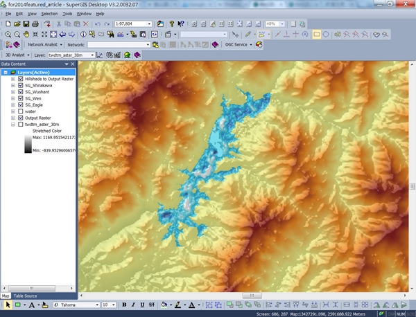
With the collaboration of Indian geospatial professional company, Satpalda Geospatial Services, the Nepali infrastructure firm in Kathmandu, Evernal Infrastructure Ltd., has selected SuperGIS Desktop 3.3 Professional and relevant extensions for analyzing topography.

SuperGIS Desktop Professional is outstanding GIS software with comprehensive tools and functions to meet specific demands of geospatial tasks with an affordable cost. For civil engineering professionals and infrastructure experts, such as the employees of Evernal Infrastructure, SuperGIS Desktop offers especially helpful and practical extensions that can simulate and analyze topographical features. Engineers can easily utilize the surface analysis tools from 3D Analyst extension to calculate aspect, slope and curvature of the surface and create contour and viewshed analyses, which are critical abilities for building infrastructure in a mountainous area like Nepal. To meet additional needs to process digital terrain data or other raster data, the Spatial Analyst extension supports diverse features such as hydrologic analysis and statistical analysis. In the latest Desktop GIS software from Supergeo— SuperGIS Desktop 10, civil engineers can take advantage of its built-in LiDAR tools, which allow users to display and manipulate LiDAR data in both 2D and 3D environments with ease.

Learn More About Spatial Analyst:
http://www.supergeotek.com/products_desktop_SA.aspx

Learn More About new LiDAR tools and SuperGIS Desktop 10:
http://www.supergeotek.com/LandingPage_SGD10.aspx
Filed Under: Software Tagged With: SuperGeo, SuperGIS Desktop

Editor’s Picks

Wider Selection of US Topo Maps From USGS Now Available in Avenza’s PDF Maps App

Mapping Reform: Where are Things Likely to Change?

Former Governor Geringer Leads Panel Calling on Congress and Governors to Make National Spatial Data Infrastructure a High Priority

47th Annual Magnet States Report — Where Did America Move in 2014?

See More Editor's Picks...

Recent Industry News

Increase Rev vs. Google AdSense: Unlocking 50%–200% Higher Earnings

August 17, 2026 By GISuser

From Simulator to Open Air: A Practical Start to FPV Flying Safely

August 14, 2026 By GISuser

Pop-Up Card Wallets vs Traditional Slim Wallets: Which Is Better?

August 11, 2026 By GISuser

Comment les PME et commerçants du Québec optimisent la livraison du dernier kilomètre pour fidéliser leurs clients

August 8, 2026 By GISuser

Hot News

State of Data Science Report – AI and Open Source at Work

HERE and AWS Collaborate on New HERE AI Mapping Solutions

Virtual Surveyor Adds Productivity Tools to Mid-Level Smart Drone Surveying Software Plan

Categories

Copyright gletham Communications 2015 - 2026

Go to mobile version