GIS user technology news

News, Business, AI, Technology, IOS, Android, Google, Mobile, GIS, Crypto Currency, Economics

  • Advertising & Sponsored Posts
    • Advertising & Sponsored Posts
    • Submit Press
  • PRESS
    • Submit PR
    • Top Press
    • Business
    • Software
    • Hardware
    • UAV News
    • Mobile Technology
  • FEATURES
    • Around the Web
    • Social Media Features
    • EXPERTS & Guests
    • Tips
    • Infographics
  • Blog
  • Events
  • Shop
  • Tradepubs
  • CAREERS
You are here: Home / **Front Page / GISuser Promotion / Unique Hand Drawn Map of London – Ten Years in the Making

Unique Hand Drawn Map of London – Ten Years in the Making

October 13, 2015 By GISuser

LONDON, October 13, 2015 – Fuller, aka Gareth Wood, a British artist, has drawn a meticulous map of London, which has taken an astonishing ten years to complete.
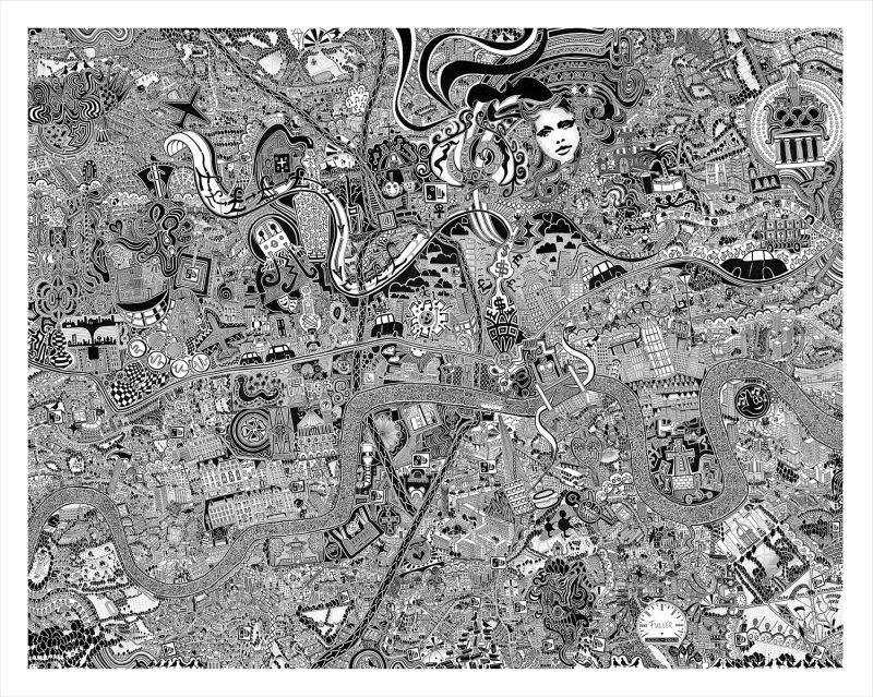
'London Town' by British Artist Fuller, aka Gareth Wood. The original art work is hand drawn using black ink on cotton archival board and measures 92cm x 116cm. The work is a mesmerising kaleidoscope to our association with youth, adolescence and progress into adulthood. Fuller lived, breathed and morphed into the capital to channel its character onto the map. (PRNewsFoto/British artist Fuller)

‘London Town’ by British Artist Fuller, aka Gareth Wood. The original art work is hand drawn using black ink on cotton archival board and measures 92cm x 116cm. The work is a mesmerising kaleidoscope to our association with youth, adolescence and progress into adulthood. Fuller lived, breathed and morphed into the capital to channel its character onto the map. (PRNewsFoto/British artist Fuller)

The work is peppered with comments on contemporary society, though personal thoughts and memories are given almost equal prominence. Unveiled in London earlier this month, it has already taken on an urban legend quality. The piece ‘London Town’, is instantly recognisable, not by the obvious landmarks, but by the hedonistic, enchanting character of the metropolis that Fuller communicates.

The artist lived, breathed and morphed into the capital city to channel its character onto the map. Delve into the cryptic drawings of London Town; the unstoppable skyscrapers, dingy underground clubs, its decadence, the infinite energy, creativity, the expansion, its systems and its future.  London Town is an emotional conversation that you can join, read, experience and create new. It is a result of Fuller’s project, Fuller Maps, which has seen him drawing a series of intricate maps that narrate and observe the identity of places. He has previously completed a map of Bristol, which took 4 years to create. Fuller describes his practice as ‘making a collection of cartographical love letters.’ His past work has been included in the Bristol Museums Historical Map Archive.

‘London Town’ can next be seen at the ‘Flux Exhibition’, Royal College of Art, London, December 11th – 14th For more information about Fuller’s art please visit http://www.fullermaps.com

Fuller created a short film whilst cycling around London on his explorations, which can be viewed here: https://www.youtube.com/watch?v=ey-Eh_uzRpY

The ten chimes from Big Ben featured in the film symbolise the ten year period in which it was drawn.

Background information

Fuller Maps is a series of works by British artist Fuller, aka Gareth Wood (b.1980). Fuller draws intricate maps that narrate and observe the identity of places. Using extensive research, local knowledge and lived experience, he immerses himself within a place to understand its complex personality. Taking on average five years to produce, Fuller meticulously creates pen drawings that exhibit pockets of narrative on contemporary society. They are entwined with stories, curiosities, factoids and personal memories. By mapping events Fuller provides a subjective account which is instantly relatable. In doing so, the artwork places prominence on shared knowledge and experience, a distinctive characteristic of Fuller’s work.

Contact email: hello@fullermaps.com

SOURCE British artist Fuller


Filed Under: GISuser Promotion, Maps and Cartography, Top Press, video Tagged With: Cartography, London, map

Top Press

The Global Expansion of Aueshah: A New Era of High Jewelry

April 11, 2026 By GISuser

KARACHI, PAKISTAN. The international luxury market is experiencing a profound shift. Consumers are increasingly rejecting mass-produced goods in favor of rarity, authenticity, and emotional depth. … [Read More...]

State of Data Science Report – AI and Open Source at Work

September 10, 2025 By GISuser

AI and Open Source at Work … [Read More...]

Topcon Announces Landmark Expansion of Topnet Live Network Across USA

January 26, 2025 By GISuser

LIVERMORE, Calif.---Topcon Positioning Systems has announced a significant expansion of its Topnet Live reference station network, introducing 200 new geodetic stations strategically positioned across … [Read More...]

Space Flight Laboratory (SFL) Announces Launch and Deployment of NorSat-4 Maritime Monitoring Microsatellite

January 19, 2025 By GISuser

Seventh Satellite Developed by SFL for Norway … [Read More...]

HERE and BMW Group extend partnership on AI-powered mapping system

January 8, 2025 By GISuser

HERE and BMW Group extend partnership on AI-powered mapping system for automated driving and enhanced road safety … [Read More...]

Everest Base Camp Helicopter Tour, Helicopter Return Trek, and Manaslu Circuit Trek: Which Nepal Adventure Is Right for You?

November 6, 2026 By GISuser

Almost everyone planning a Nepal trip runs into the same wall. You want the big mountains, you have a fixed number of days, and every itinerary you read seems to promise something … [Read More...]

SFL Missions Inc. Confirms Successful Deployment of Six HawkEye 360 Radio Frequency Detection Satellites with Advanced Capabilities

October 27, 2026 By GISuser

MĀHIA, New Zealand, 26 October 2026 – SFL Missions Inc. today confirmed the successful deployment of six radio frequency (RF) detection and geolocation satellites for HawkEye 360 … [Read More...]

Canadian-Built RoadEng 12 Uses AI to Find the Best Location for New Resource and Rural Roads

October 17, 2026 By GISuser

Vancouver, BC, Canada, October 15, 2026 – North Vancouver-based Softree Technical Systems today released RoadEng Version 12, used in more than 75 countries to locate and design … [Read More...]

Beyond the Map: How AI Image and Video Generation Is Changing Geospatial Communication

October 14, 2026 By GISuser

Ask anyone who has shipped a GIS project what the hardest part was, and the answer is rarely the spatial analysis. It is almost always the communication. A site suitability … [Read More...]

From Maternity to Everyday Wear: Building a Wardrobe That Grows With You

October 14, 2026 By GISuser

When I think about maternity clothing, I feel the biggest mistake is buying too many things at once. During pregnancy, your body keeps changing, and something that fits well today … [Read More...]

Copyright gletham Communications 2015 - 2026

Go to mobile version