There is a lot of talk about Big Data and what it means. Geographic Information Systems is a perfect platform for taking advantage of this data. A great deal of mapping data is public information, and can be accessed freely. So what are some of the ways we are using this data, and what opportunities does it create?
“Geography is destiny in medicine.” – Jack Lord, MD Dartmouth Atlas of Healthcare
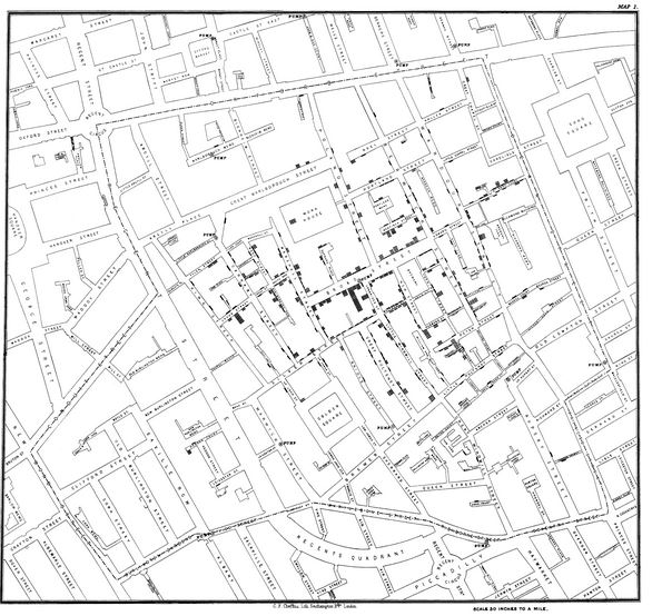
Photo Credit: Wikipedia
Mapping Health Issues
In 1854, John Snow used mapping to analyze a cholera outbreak in London, so this application is not new, but we have much more advanced tools. More recently, GIS was used to help stem the Ebola outbreak..
At a 2013 conference in Cambridge, Massachusetts organized by ESRI, a provider of GIS products and services, the Louisiana Department of Health presented a fine-grained mapping program where they allowed the ESRI software to find clusters of events near each other, and create a map using that data.
Because fine grained mapping requires addresses, which are part of personally Identifiable information (PII), the data cannot be released to the public, but provides significant information. The instances of specific diseases or health issues were often clustered around a housing development or neighborhood. The mapping also showed a pattern over a particular waterway, which was then deduced was contaminated.
 Photo Credit: Stanford
Mapping Potential Causes for Disease
Using correlations between data sets, researchers can determine if certain environmental or other factors might potentially be causes of disease. One study, conducted by Carrie Tayour, MPH , Toxics Epidemiology Program, Los Angeles County Department of Public Health and Myles Cockburn, PhD , Department of Preventive Medicine, University of Southern California used GIS to map historical pesticide use to determine if it was a potential cause for cancer.
Mapping Patient Environmental History
As valuable as residential data is, physicians and other health care providers often do not gather it, even when it is available. Bill Davenhall, a health and human services expert, gave a TED talk in 2009 about your health depending on your location. but the practice of gathering residential history has yet to be adopted by most physicians.
 Photo Credit: CDC
Although diagnosis is related to genetics, lifestyle, and environment, the last item is often neglected, Davenhall states. The forms you fill out at your doctor seldom ask for environmental history. Tools like the the EPA’s Toxic Release Inventory would make this very easy to add to charting, and could be quite valuable in diagnosis and recommending lifestyle changes. My Place History is an ESRI based app that correlates public health information with your environmental history, but is so far only available on iOS.
While Geomedicine is a growing field, the amount of data that needs to be gathered and stored for a truly accurate picture is enormous. As more methods emerge for handling big data, it is hoped that medical records will include geocoded data on a regular basis.
Mapping for Child Welfare
Kathyrn Kulbicki, a GIS analyst at Westat, a research company in Rockville, Maryland, said “social work and mapping hasn’t really been happening.” She has been working with the National Resource Center for Child Welfare and Technology to help it figure out how to use GIS tools. For instance, can child welfare organizations map foster children in relation to schools and welfare offices, or how far families live from the homes where their children have been placed?
Mapping the Homeless
Homelessness is a large public health and social issue, and efforts from mapping the density of homelessness by state to more focused mapping efforts in large cities like Los Angeles and Baltimore are being done to better allocate resources and focus on solutions.
One of the best examples is the Homeless Information Management System being used in Baltimore, which allows for tracking of the chronically homeless, and contains data not stored anywhere else. This informs shelter workers and resource managers so they can better assist the members of their community.
Author:
Troy Lambert is a freelance writer, editor, and non-profit consultant by day, and a suspense thriller author by night. He learned about the power of GIS while working as a researcher at a museum, and is always looking for ways to apply this technology and big data in new and innovative ways. Troy is an avid cyclist, skier, and hiker. He lives, works, and plays in Boise, Idaho. His work can be found at troylambertwrites.com, and you can connect with him on Twitter @tlambertwrites.