GIS user technology news

News, Business, AI, Technology, IOS, Android, Google, Mobile, GIS, Crypto Currency, Economics

  • Advertising & Sponsored Posts
    • Advertising & Sponsored Posts
    • Submit Press
  • PRESS
    • Submit PR
    • Top Press
    • Business
    • Software
    • Hardware
    • UAV News
    • Mobile Technology
  • FEATURES
    • Around the Web
    • Social Media Features
    • EXPERTS & Guests
    • Tips
    • Infographics
  • Blog
  • Events
  • Shop
  • Tradepubs
  • CAREERS
You are here: Home / * PRESS / Software / Web Mapper, Mapping Straight

Web Mapper, Mapping Straight

September 2, 2015 By GISuser

Today, when spatial data is highly utilized and conveys essential day-to-day information to the public, it is very important that people can access spatial information anytime and anywhere. Smart phones offer a convenient way to connect to Information Clouds. Therefore, Supergeo believes that only when maps are available through smart phones can map information be truly and broadly shared. Although SuperGIS Server 3.2 provide users with easy configurations to build up web applications based on JaveScript, Flex, and Silverlight, these applications are designed for Windows and Mac platforms rather than mobiles. People who browse these map applications with smart phones will often find the experience disappointing.

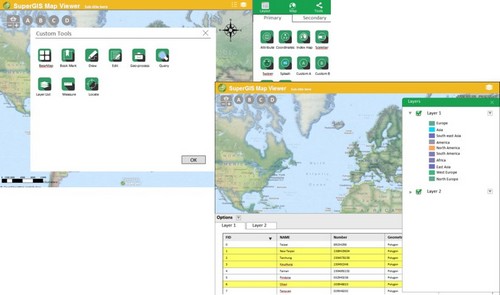
Now, Supergeo is designing a new tool, Web Mapper, for all SuperGIS Server users to effortlessly build up web applications for all Windows, Mac, Android, and iOS users. Web Mapper provides developers with a friendly user interface that gives them high flexibility in customizing a web application with no need to write code on their own. Once the tools are completed, the applications will be capable of providing smart phone users with better user experiences while using the map information to find points of interest, perform geographical analyses, or even make presentations to share geographic spatial information with more people.

Web Mapper will come with the release of SuperGIS Server 10 series, and will be one of the new features in SuperGIS Online. Stay tuned, and we will bring more details about this exciting new tool. 

Contact us and try out SuperGIS Server: staff@supergeotek.com
More info

Filed Under: Software, Web Services Tagged With: Web Mapper

Editor’s Picks

Using Lidar to Classify Landslides

2014 Open Data for Development Research Grants – Call for Proposals

Infographic – The History of the iPhone

A Possible Date Conflict with 2016 ESRIUC and the MLB All Star Game

See More Editor's Picks...

Recent Industry News

Why Bathroom Renovation Services Often Change More Than Just the Bathroom

May 20, 2026 By GISuser

The Drift Between Early Notes and Final Case Files in Abuse-Related Legal Support

April 29, 2026 By GISuser

Aerial Surveys Int’l and Global Marketing Insights to Present GEOINT 2026 Workshop on Multi-Domain Geospatial Fusion for Automated Infrastructure Monitoring

April 24, 2026 By GISuser

Why Timing Matters More Than You Think With Spray Seal (And Why People Often Get It Slightly Wrong)

April 22, 2026 By GISuser

Hot News

State of Data Science Report – AI and Open Source at Work

HERE and AWS Collaborate on New HERE AI Mapping Solutions

Virtual Surveyor Adds Productivity Tools to Mid-Level Smart Drone Surveying Software Plan

Categories

Copyright gletham Communications 2015 - 2026

Go to mobile version