New program gives Leica Geosystems customers easy and free access through the cloud to intelligent imagery with the newest generation of robotic total stations and GNSS/GPS handhelds.
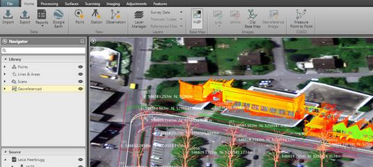
Leica Geosystems today announced that it is taking the first step toward bringing live-streamed intelligent cloud-based imagery into all field applications, beginning with the launch of the Leica Nova MS60 MultiStation, Leica Nova TS60 Total Station, Leica Viva TS16 Total Station and Leica Zeno 20 handheld. Geospatial professionals in the U.S. and Canada who invest in these new solutions can become part of this pioneering effort and add even more intelligence to their dataset with up to one year of introductory free access to georeferenced imagery from the Hexagon Imagery Program (HxIP).
A high-quality, accurate and professional dataset, HxIP imagery is 30 cm (1 foot) resolution, with set specification and accuracy standards and a regular refresh schedule. The natural color RGB backdrop imagery (tile cache) is fast and easy to access and gives context to survey and construction maps and overlays. All content is captured using Leica Geosystems airborne sensors for the highest reliability.
Access to HxIP imagery adds spatial and contextual awareness to surveys, enables better planning and decision-making for more efficient and productive time onsite, and eliminates the need to georeference data to the basemap during post-processing. Through Leica Infinity software, users can access HxIP imagery to view field measured data and imported design data in the office. Users can also prepare job data with the HxIP imagery and then clip and store georeferenced images that can be exported to the new Leica Captivate field software for use as background imagery and basemaps on the newest robotic total stations. The imagery can also be live-streamed to the Leica Zeno 20 handheld.
The georeferenced HxIP airborne imagery is available to everyone on a subscription basis through the cloud via multiple content service providers, including Esri’s ArcGIS Marketplace, Hexagon Geospatial’s Power Portfolio and Valtus Imagery Services. Complimentary access to live-streamed HxIP image tiles is being offered through June 2016 to customers in the U.S. and Canada that have an active Leica Infinity Customer Care Package (CCP) or that purchase a Leica Zeno 20 handheld.
“We’re quickly moving toward a world in which every geospatial sensor will have cloud-based access to real-time, high-quality imagery for invaluable survey intelligence,” said Ken Mooyman, president of Hexagon Geosystems NAFTA. “The integration of HxIP with Leica Infinity, Captivate and the Leica Zeno 20 in North America is the first step in bringing that rich, detailed imagery to users where and when it is available so they can be part of leading the way into the future.”
For more information about HxIP, visit www.leica-geosystems.com. To learn how you can take advantage of the free one-year access to HxIP, contact your Leica Geosystems sales rep or dealer.
Leica Geosystems – when it has to be right
With close to 200 years of experience pioneering solutions to measure the world, Leica Geosystems products and services are trusted by professionals worldwide to help them capture, analyze, and present spatial information. Leica Geosystems is best known for its broad array of products that capture accurately, model quickly, analyze easily, and visualize and present spatial information.
Those who use Leica Geosystems products every day trust them for their dependability, the value they deliver, and the superior customer support. Based in Heerbrugg, Switzerland, Leica Geosystems is a global company with tens of thousands of customers supported by more than 3,800 employees in 33 countries and hundreds of partners located in more than 120 countries around the world.