GIS user technology news

News, Business, AI, Technology, IOS, Android, Google, Mobile, GIS, Crypto Currency, Economics

  • Advertising & Sponsored Posts
    • Advertising & Sponsored Posts
    • Submit Press
  • PRESS
    • Submit PR
    • Top Press
    • Business
    • Software
    • Hardware
    • UAV News
    • Mobile Technology
  • FEATURES
    • Around the Web
    • Social Media Features
    • EXPERTS & Guests
    • Tips
    • Infographics
  • Blog
  • Events
  • Shop
  • Tradepubs
  • CAREERS
You are here: Home / * PRESS / Government & OpenGov / First Lady Michelle Obama Launches Let’s Move! Interactive Map

First Lady Michelle Obama Launches Let’s Move! Interactive Map

April 15, 2015 By GISuser

To celebrate the fifth anniversary of Let’s Move!, First Lady Michelle Obama and The Partnership for a Healthier America, launched the Let’s Move! interactive map to encourage healthier lifestyles for kids. Available to the public online, the map showcases the impact of these programs across the nation and makes it easier to get involved in local efforts.

First Lady Michelle Obama Launches Let’s Move! Interactive Map

First Lady Michelle Obama Launches Let’s Move! Interactive Map

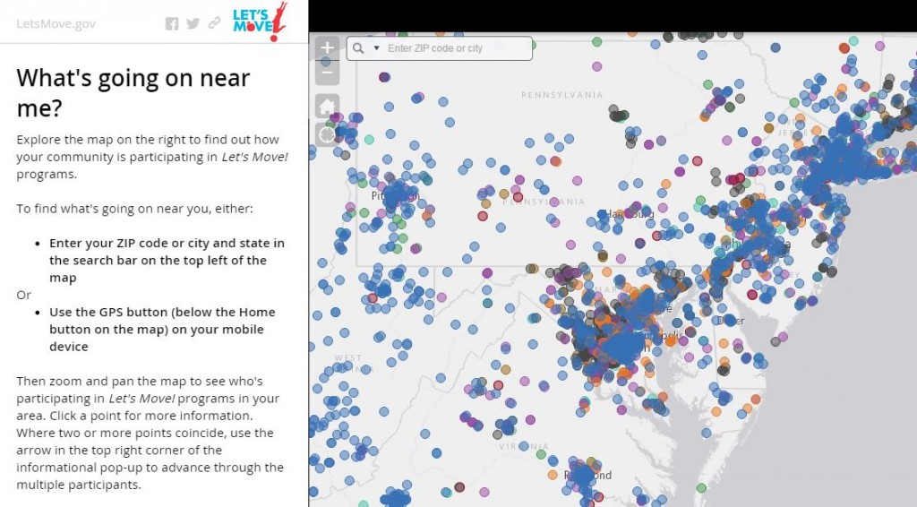
Built on Esri’s ArcGIS Online platform, the map allows users to search for their location (city or ZIP) to see what schools, localities, or organizations near them are participating in a Let’s Move! program. You can also view a full-screen app to explore each program individually.

As part of the fifth anniversary of Let’s Move!, Mrs. Obama will announce a new interactive map that will be available to the public online.  The map will showcase the impact of these Let’s Move! programs across the nation and make it easier to get involved in local efforts. In addition, the First Lady will share a special #GimmeFivegarden challenge as part of her Let’s Move! fifth anniversary challenge encouraging Americans to #GimmeFive things they are doing to lead healthier lives.

The First Lady’s remarks will be livestreamed at www.whitehouse.gov/live.

Full Map Tour: http://www.arcgis.com/apps/MapJournal/?appid=7e0ab72747c94b5c89c9ede3798375a4

White House Press Release

Filed Under: Government & OpenGov, Maps and Cartography, Top Press Tagged With: Interactive Map, Michelle Obama

Editor’s Picks

Data Tip – The US Interagency Elevation Inventory

Maps attributed to the 13th-century traveler sketch what looks like the coast of Alaska

A New, Official Arkansas GIS Web Portal

Former Governor Geringer Leads Panel Calling on Congress and Governors to Make National Spatial Data Infrastructure a High Priority

See More Editor's Picks...

Recent Industry News

The Drift Between Early Notes and Final Case Files in Abuse-Related Legal Support

April 29, 2026 By GISuser

Aerial Surveys Int’l and Global Marketing Insights to Present GEOINT 2026 Workshop on Multi-Domain Geospatial Fusion for Automated Infrastructure Monitoring

April 24, 2026 By GISuser

Why Timing Matters More Than You Think With Spray Seal (And Why People Often Get It Slightly Wrong)

April 22, 2026 By GISuser

The Quiet Planning Stage Most People Don’t See When Building a Pool in Brisbane

April 22, 2026 By GISuser

Hot News

State of Data Science Report – AI and Open Source at Work

HERE and AWS Collaborate on New HERE AI Mapping Solutions

Virtual Surveyor Adds Productivity Tools to Mid-Level Smart Drone Surveying Software Plan

Categories

Copyright gletham Communications 2015 - 2026

Go to mobile version