GIS user technology news

News, Business, AI, Technology, IOS, Android, Google, Mobile, GIS, Crypto Currency, Economics

  • Advertising & Sponsored Posts
    • Advertising & Sponsored Posts
    • Submit Press
  • PRESS
    • Submit PR
    • Top Press
    • Business
    • Software
    • Hardware
    • UAV News
    • Mobile Technology
  • FEATURES
    • Around the Web
    • Social Media Features
    • EXPERTS & Guests
    • Tips
    • Infographics
  • Blog
  • Events
  • Shop
  • Tradepubs
  • CAREERS
You are here: Home / * PRESS / Environment / Data Tip – California Drought Visualization website

Data Tip – California Drought Visualization website

March 4, 2015 By GISuser

An eye-catching example of OWDI success is the USGS interactive California Drought Visualization website, released in December 2014.

California Drought Visualization website

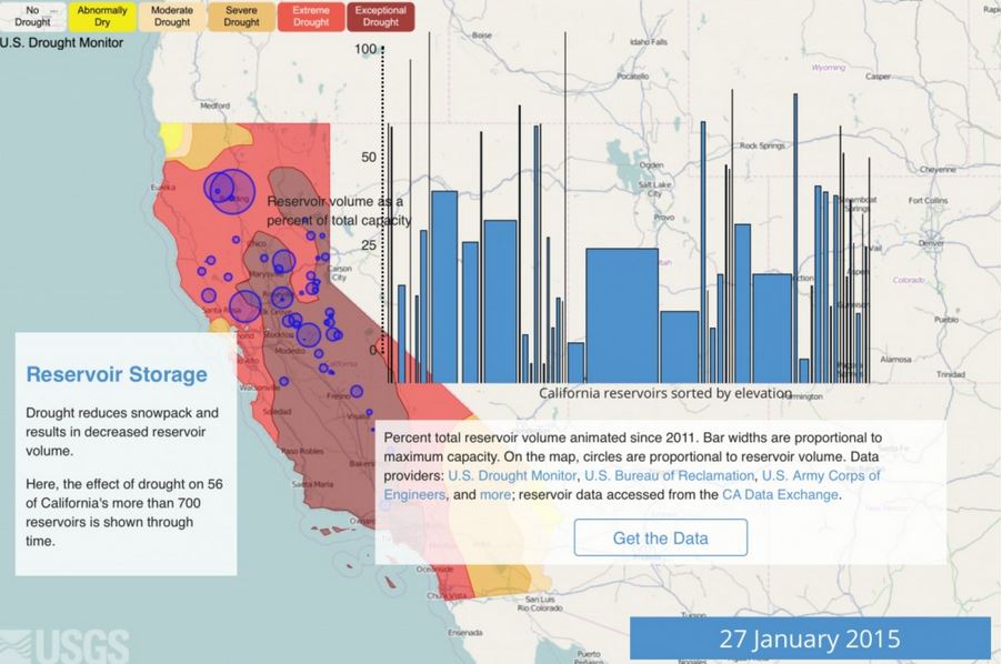
A sample screen from the California Drought Visualization website. Click on the image to go to the website and track both historical and current conditions

This visualization tool is designed to provide the public with atlas-like, statewide coverage of the drought and a timeline of its impacts on water resources. In partnership with the Bureau of Reclamation, options are being explored to expand the visualization to describe conditions across the lower Colorado River region.

The application accesses data from a variety of sources to create a useful “toolbox” for key stakeholders to use when making tough choices about water use, presenting them with valuable water data arranged in a storyline that conveys the complexity of Western water management in a more understandable and interactive format.

Two additional OWDI examples that are transitioning from concept to action are the National Flood Interoperability Experiment and a water quality incident response tool to address situations such as the 2014 Elk River chemical spill near Charleston, West Virginia.

While these examples illustrate how the data can be applied, the focus of the OWDI is not so much on specific applications but on the data behind them. The goal of the initiative is to make all water data from a wide variety of sources discoverable and readily accessible via web interfaces.

The anticipated outcome of the improved availability of real-time data is the distributed development of more complex automated data processing — for instance, models that automatically ingest updated data streams to produce modeled results in real time. A public “marketplace” is also envisioned where innovators inside and outside government can feature open source tools that are based on data liberated through the initiative.

Learn more  

Open Water Data Initiative
USGS Water Data Discovery
White House: Data to Boost Ecosystem and Water Resilience

Filed Under: Environment, Maps and Cartography, SPOTLIGHTS, Tips, Top Press Tagged With: California Drought Visualization

Editor’s Picks

Unlocking your Location Data History on Social Media

Maps attributed to the 13th-century traveler sketch what looks like the coast of Alaska

Visual Intelligence Wins Grand Award and Technology Innovation Award

Arkansas.gov Ranks Among Top 3 Government Websites

See More Editor's Picks...

Recent Industry News

The Future of Competitive Gaming: Why DMA Technology is the Ultimate Performance Edge

June 24, 2026 By GISuser

Milwaukee M18FHZ-0 Hackzall Reciprocating Saw – For hardcore cutting in a compact size

June 19, 2026 By GISuser

How Enterprises Are Using AI to Automate 80% of Customer Interactions With Voice Agents

June 16, 2026 By GISuser

Why On Cloud Shoes Are Worth the Price in Mexico

June 16, 2026 By GISuser

Hot News

State of Data Science Report – AI and Open Source at Work

HERE and AWS Collaborate on New HERE AI Mapping Solutions

Virtual Surveyor Adds Productivity Tools to Mid-Level Smart Drone Surveying Software Plan

Categories

Copyright gletham Communications 2015 - 2026

Go to mobile version